
Seattle Fault Bigger Quake Threat Than Thought
A new word of caution for Seattleites: The big quake you've been waiting for could be even bigger than expected.
The Seattle Fault, a zone of east-west thrust faults under the Puget Sound and Seattle, last ruptured in a magnitude-7.0 to -7.5 earthquake about 1,100 years ago. It's due for another one, but scientists don't know when that might happen.
Whenever it does, the quake — and ensuing hazards like landslides or a tsunami — could be larger and affect a wider area than scientists had calculated, according to recent research from the University of Washington.
"Before, it looked like the Seattle Fault had a very narrow zone that was deformed during the last major earthquake, but this evidence shows that the zone of deformation was actually several kilometers wider," said Maria Martin Arcos, a geologist with the engineering firm AMEC, who completed the research while she was a doctoral student at the University of Washington.
"This also shows that when you think about an earthquake, you also have to think about and plan for these other things, like landslides and tsunamis, that can come along with it," Arcos told OurAmazingPlanet.
Triple threat
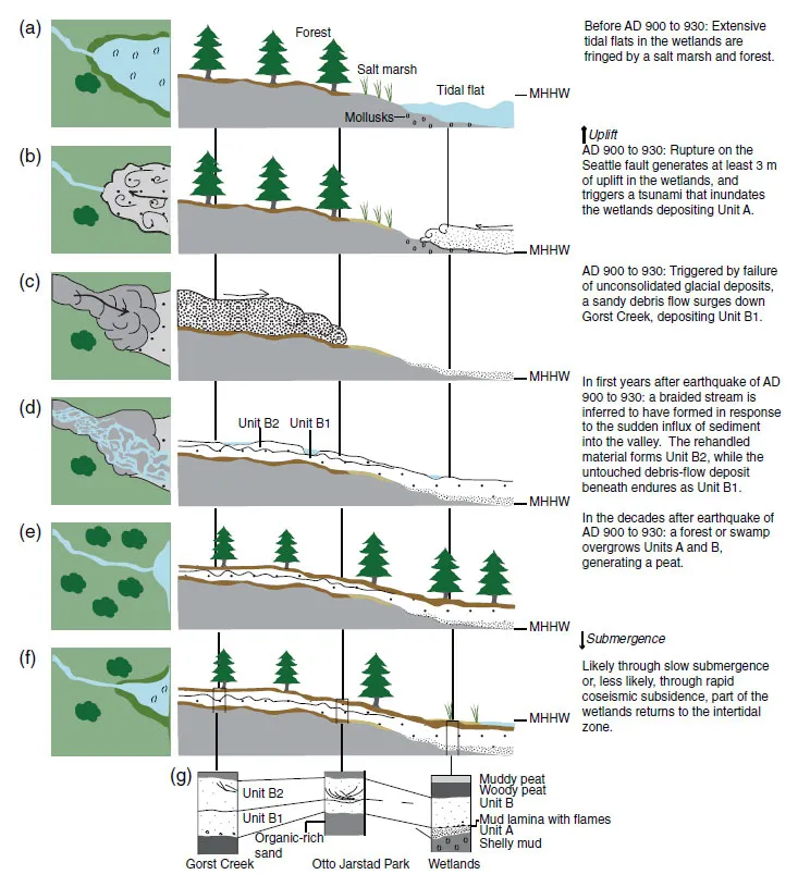
Native American oral legends recount a major earthquake near Seattle around A.D. 900-930, but those are the only human records of the event. To learn more about the prehistoric quake — and what the Seattle Fault might have in store for future ruptures — researchers have had to dig into the geologic record.
Arcos looked for evidence in a coastal marsh near Gorst, Wash. Geophysical models of the fault predicted that the prehistoric quake didn't deform this area, but Arcos discovered that parts of the marsh had been lifted about 10 feet (3 meters) during the quake.
She found a layer of big cedar trunks, forest peat and seeds and leaves from land plants directly on top of a layer full of clams, mussels and mud. Together, the two layers are evidence that the quake suddenly lifted land in an intertidal zone, turning it into a forested zone.
Also, a sandy layer deposited by a tsunami and a layer of forest turf torn up during a landslide showed that at least two violent events accompanied the major earthquake, Arcos said.
Bigger danger zone
A better understanding of the Seattle Fault's structure will help researchers forecast which areas might experience intense ground shaking in future quakes, Arcos said.
Her research indicates that a zone 6 to 7 miles (10 to 12 kilometers) wide could be deformed in a future quake with a magnitude up to 7.5. Previous estimates showed the danger zone was only about 4 to 5 miles (7 to 8 km) wide. [Video: What Earthquake 'Magnitude' Means]
"We know where most of the big plate boundary faults are, and we have some ideas as to how they behave. But for these smaller faults, we don't really know where all of them are or how all of them behave," Arcos said. "This fault runs right under the city of Seattle, and we're still finding new things almost every year."
Arcos' research is detailed in the June 2012 issue of the journal Bulletin of the Seismological Society of America.
This story was provided by OurAmazingPlanet, a sister site to LiveScience. Follow OurAmazingPlanet for the latest in Earth science and exploration news on Twitter @OAPlanet. We're also on Facebook and Google+.
