'Monsoon on steroids' has flooded vast swaths of Pakistan, disturbing satellite images show
More than 1,000 people have died in the floods.

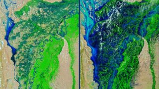
New satellite images show the extent of the catastrophic floods now inundating Pakistan, leaving approximately one-third of the country underwater. The worst of the floods occurred along a stretch of the Indus River that overflowed, forming a massive lake.
The flooding, driven by unusually heavy monsoon rains, has affected more than 33 million people in Pakistan and killed more than 1,100 since mid-June, including hundreds of children, NPR reported. Millions of acres of cropland, thousands of miles of roads and more than a million homes have been damaged by the floodwaters. In a video posted to Twitter, Sherry Rehman, a Pakistani senator and the country's top climate official, called the historic floods "serious climate catastrophe, one of the hardest in the decade."
Satellite images, shared by the NASA Earth Observatory on Aug. 28, revealed how the floodwaters transformed the country's landscape between early and late August. For example, on Aug. 4, about 30 miles (48 kilometers) of land stood between the Indus River and Hamal Lake, located west of the river in the Qambar Shahdadkot District of Pakistan. But by Aug. 28, the two bodies of water had merged with one another.
The European Space Agency shared similar images of the flooding on Aug. 30, with submerged land marked in blue and black. These images, captured by the Copernicus Sentinel-1 satellite, highlighted the region between the cities of Dera Murad Jamali and Larkana, which respectively lie northeast and due east of Hamal Lake. Again, the snapshots show where the once-winding Indus River has now been replaced by a vast lake.
Related: Has the Earth ever been this hot before?

NASA Earth Observatory also shared images of the cities of Qambar and Shikarpur in Sindh province that revealed how dramatically the floodwaters advanced between early and late August. Both cities have seen about 500% higher-than-average rainfall between July 1 and Aug. 31.
Overall, the recent rainfall in Pakistan has been about three times heavier than the 30-year nationwide average, The New York Times reported. This increase in rainfall can likely be attributed to climate change, as Pakistan's chief climate official indicated.
Sign up for the Live Science daily newsletter now
Get the world’s most fascinating discoveries delivered straight to your inbox.
Experimental data and climate models suggest that, as average global temperatures rise, historically wet regions will face more extreme precipitation events, like monsoons, while historically dry regions will grow drier as the rising heat drives water to evaporate more efficiently, Live Science previously reported. So climate change essentially intensifies the water cycle, leading to more extreme and more frequent weather events.
In addition to devastating monsoons, Pakistan had been contending with glacial-outburst floods, or the sudden release of water from glacial lakes, according to NASA Earth Observatory. Pakistan, with its roughly 7,000 glaciers, contains the most glacial ice of any country beyond the polar regions. Particularly in northern regions of the country, the meltwater from these glaciers sometimes compounds the damage caused by rainwater.
Originally published on Live Science.

Nicoletta Lanese is the health channel editor at Live Science and was previously a news editor and staff writer at the site. She holds a graduate certificate in science communication from UC Santa Cruz and degrees in neuroscience and dance from the University of Florida. Her work has appeared in The Scientist, Science News, the Mercury News, Mongabay and Stanford Medicine Magazine, among other outlets. Based in NYC, she also remains heavily involved in dance and performs in local choreographers' work.
