Live
Iceland volcano LIVE: Likelihood of further eruptions diminished, lava flows appear to have ceased
Latest updates on the volcano on Iceland's Reykjanes peninsula, which began erupting on Monday (Dec. 18) north of the small fishing village of Grindavík following weeks of localised earthquakes and sinkholes.
This live blog has now ended
A volcano in Iceland is now erupting after weeks of earthquakes rocking the region, according to a statement released by the Iceland Met Office on Monday (Dec. 18).
The country has been bracing itself for an imminent volcanic eruption on the Reykjanes Peninsula for weeks. Grindavík, a small fishing town in the southwest corner of the island with a population of around 2,800 people, had previously been evacuated in November after a sinkhole measuring 3.2 feet (1 meter) deep appeared in the town.
Seismic activity began increasing in the area around the Fagradalsfjall volcano on Oct. 25, when more than 1,000 earthquakes north of Grindavík occurred in the space of just hours. Two strong earthquakes, measuring magnitudes 3.9 and 4.5, hit at a depth of around 3 miles (5 kilometers). Over the following two weeks, seismic activity continued, with hundreds of earthquakes and uplift recorded each day, indicating that magma was accumulating beneath the ground.
Timeline of events:
- Dec. 18 — Volcano erupts just north of Grindavík at 22.17 [5:17 p.m. EST Eastern Time].
- Nov. 20 — IMO releases new map showing extended "danger zone" around the magma dike. Hagafell currently considered the most likely spot for a fissure to appear.
- Nov. 15 — IMO reports seismic activity has remained consistent since Nov. 11, with monitoring centered around Grindavík.
- Nov. 14 — Icelandic authorities create makeshift defenses to protect the Svartsengi geothermal power plant from lava flows.
- Nov. 10 — Grindavík evacuated due to the increase in seismic activity gravitating towards the fishing village. Icelandic authorities declare a state of emergency.
- Nov. 9 — The largest recorded earthquake since the swarm began reaches a magnitude of M4.8. Blue Lagoon geothermal resort, one of the country's most famous tourist attractions, is temporarily closed.
- Nov. 4 — Seismic activity decreases considerably, but Icelandic Meteorological Office continues to monitor the situation.
- Oct. 25 — Seismic activity in the Reykjanes Peninsula increases with more than 1,000 earthquakes registered in the area, the largest with a magnitude of M4.5.
LIVE: Latest Updates
'Time's finally up': Impending Iceland eruption is part of centuries-long volcanic pulse

Cracks and sinkholes have formed in the Icelandic town of Grindavík
Iceland's potentially imminent eruption in the Reykjanes Peninsula is part of a 1,000-year cycle of volcanic activity that will likely cause eruptions for centuries, scientists say.
"Time's finally up," Edward W. Marshall, a researcher at the University of Iceland's Nordic Volcanological Center, told Live Science in an email. "We can get ready for another few hundred years of eruptions on the Reykjanes."
Seismic activity began increasing in the south of the peninsula in October, with hundreds of earthquakes recorded there each day. On Nov. 10, authorities evacuated the town of Grindavík, with experts warning an volcanic eruption could take place in just days.
'Time's finally up': Impending Iceland eruption is part of centuries-long volcanic pulse
800 earthquakes recorded since midnight
Around 800 earthquakes have been recorded since midnight, Nov. 15. Most hit at the center of the magma dike, according to a translated statement from the IMO.
The continuing ground deformation is likely being caused by magma flowing into the dike, experts say
"Part of the magma dike seems to be solidifying, especially at the edges, but not at the magma inflow area, which is believed to be near Sundhnúk," according to the statement. "The probability of an eruption is still considered high. In the event of an eruption, the most likely location is at the magma dike."
Officials scramble to protect vital power plant from imminent lava flows

The Svartsengi geothermal power plant is located very near to where the eruption may occur.
On Tuesday (Nov. 14), Icelandic authorities started creating makeshift defenses to protect the Svartsengi geothermal power plant from lava flows that may emerge if the magma dike erupts over the next few days, Reuters news agency reported.
The Svartsengi plant uses heat from the underground magma in the region to heat water and turn turbines. It is located around 4 miles (6 km) from Grindavík, which has been evacuated over fears of the imminent eruption, and supplies power across the country, as well as hot water to the local area.
Workers have begun digging out channels to divert the lava away from the plant if molten rock heads in that direction.
Why is Iceland so volcanically active? A geologist explains.

Iceland’s volcanic activity is generally tame compared with explosive eruptions along the Pacific’s Ring of Fire. Jaime Toro, Professor of Geology at West Virginia University, explains what the main causes for volcanic activity in the region are, and what effect this has on eruptions.
"The answer has two parts — one has to do with what geologists unimaginatively call a hotspot, and the other involves giant tectonic plates that are pulling apart right beneath the island."
What will the imminent volcanic eruption in Iceland really look like?

Experts have warned that an underground magma tunnel between a pair of Icelandic towns could erupt at any moment. But what will this eruption look like? And how far-reaching will its effects be?
Could scientists artificially trigger the eruption safely?
There have been no new reports from the IMO since yesterday (Nov. 15) of any further earthquakes or the likelihood of an eruption, and as such the situation remains unchanged.
But would it be possible to prematurely trigger the upcoming eruption by drilling into the magma dike beneath the surface, potentially helping to control where the lava flows out of the ground? We asked an expert, who told us that it probably couldn't work.
"I am not sure that it is technically possible," Benjamin Andrews, a geologist at the Smithsonian Institute's National Museum of Natural History and director of the institute's Global Volcanism Program, told Live Science.
The magma in the dike is very viscous and would not be able to flow through a narrow opening, Andrews said. So "a very large hole would need to be bored for the magma to flow through." With magma reaching temperatures between 2,000 and 2,200 Fahrenheit (1,100 to 1,200 degrees Celsius), any drilling equipment would also likely be destroyed by the molten rock, he added.
Even if an eruption could be artificially triggered, this type of geoengineering solution is also "fraught from a legal and ethical standpoint," Andrews said.
Eruption still likely in next few days, experts say

If an eruption takes place, it is most likely to be north of Grindavík, near Hagafell, IMO representatives wrote in a statement.
An eruption is still likely to take place over the coming days, experts have said. Kristín Jónsdóttir, program director for earthquake monitoring at the Icelandic Meteorological Office, told Iceland's national broadcasting service RÚV that the probability of an eruption is not decreasing and seismic activity is being monitored closely.
She said the only experience they have is the 2021 eruption of Fagradalsfjall. In this event, tens of thousands of earthquakes were recorded in the weeks leading up to the eruption.
According to an updated statement from the IMO, 2,000 earthquakes have been recorded in the region in the last 24 hours. Ground deformation is ongoing, although its rate is slowing. If an eruption does take place, it is most likely to be north of Grindavík, near Hagafell.
"There is still a high probability of a volcanic eruption," representatives wrote.
Lava could reach the Blue Lagoon and Svartsengi power plant in days
If the magma dike beneath Iceland's Reykjanes Peninsula erupts, lava flows could quickly reach the Blue Lagoon resort and the Svartsengi geothermal power plant.
Magma is currently estimated to be 2,600 to 1,640 feet (800 to 500 m) below the surface and the rate of inflow to the dike appears to be constant, meaning the risk of eruption is still very high.
"If magma inflow continues at a constant rate for an extended period, I imagine the dike will grow and reach the surface in the coming days or weeks," Alberto Caracciolo, a researcher at the University of Iceland's Institute of Earth Sciences, told Live Science in an email.
"The extent of lava flows will vary depending on the specific location where the fissure opens, on the magma output rate and on the duration of the eruption," he said. "However, in most of the scenarios, lava could reach the power plant and the Blue Lagoon very quickly, in less than [a] few days. A similar fate is likely expected for Grindavík, especially if the fissure opens up in the southernmost part of Hagafell."
Iceland volcano could burst like a ‘fizzy drink’, with lava reaching Blue Lagoon resort in days
Land at Svartsengi power plant rising at a faster rate

Map showing the magma dike and the areas that could be impacted if a volcanic eruption takes place, including the Svartsengi power plant, the Blue Lagoon and the town of Grindavík.
Thorvaldur Thordarson, a volcanologist at the University of Iceland, has said the rate of uplift around the Svartsengi power plant, which feeds the nearby Blue Lagoon spa resort, is now faster than it was before Nov. 10, when a magma dike formed beneath the ground in the south of Reykjanes Peninsula.
"This goes hand in hand as the magma is creating space and lifting the surface of the earth up," he told the Iceland Monitor, according to a translation.
Thordason told Iceland's national broadcaster RUV that the land around Svartsengi initially fell around 15 inches (40 centimeters), but it is now almost back to its previous level. "When it reaches a similar level as it reached before November 10, you can expect something to happen," he said, according to a translation.
Freysteinn Sigmundsson, a geophysicist at the University of Iceland, said the most likely explanation for the uplift was magma flowing into the region. He told the Iceland Monitor that what happens next depends on how much the magma moves and how fast, adding that the sequence of events taking place is similar to what happened before the eruption of Fagradalsfjall in 2021 — except in this event the magma was much deeper.
"Then I think an eruption over the current magma tunnel is the most likely scenario."
According to RUV, 460 earthquakes have been recorded at the magma dike since midnight.
Danger zone from impending eruption has expanded

Map showing the zones at risk from a volcanic eruption in Iceland.
A new map showing the areas experts believe are at greatest risk from the impending volcanic eruption has been released by representatives with the IMO.
In a translated statement, they wrote that new satellite images showing Svartsengi and the magma dike mean the "danger zone has been expanded."
The zones at greatest risk include Hagafell, which is about halfway along the 9.3 mile (15 kilometer) magma dike, to the northwest of Grindavík. This region is considered to be the most likely place for an eruption to occur. Grindavík is placed in the red zone, which means there is a risk of a fissure opening at short notice and releasing lava, but the risk is smaller than in the purple zone.
Svartsengi in the north is at risk of experiencing earthquakes.
Weather to impact monitoring
Earthquake activity along the magma dike appears to have dropped slightly compared with recent days. However, this may be the result of strong winds impacting the sensitivity of seismic instruments, making it difficult to detect the smallest earthquakes according to the IMO.
"The effectiveness of this monitoring depends on the good sensitivity of seismic and real-time GPS measurements, but the sensitivity is highly dependent on weather conditions," IMO representatives wrote in a translated statement. Strong winds and rain are expected for the next two days, meaning real-time monitoring will be reduced.
Experts "will continue to monitor the area as well as possible and constantly reevaluate and interpret the data that is received."
What are the signs an eruption is just about to happen?
What will happen just before a fissure appears at the surface is currently unclear — although the presence of gases like sulfur dioxide and carbon dioxide would indicate magma is close to the surface. Increased seismic activity could also suggest heightened activity beneath the ground.
"Another sudden increase in magnitude and number of earthquakes would be a bad sign," Jaime Toro, professor of geology at the West Virginia University, told Live Science in an email. "Also, continuing ground deformation, increase of surface heat flow, gas emissions. In other words, the things that are happening."
Ármann Höskuldsson, a volcanologist with the University of Iceland's Nordic Volcanological Center, told Live Science in an email that low-frequency earthquakes would be a telltale sign, as it would suggest CO2 has started to escape the magma.
Earthquake activity is also associated with the movement of magma. However, before the eruptions at the nearby Fagradalsfjall volcano, seismic activity appeared to drop off before a fissure appeared. "There was a silent spot before magma reached the surface and erupted," Dave McGarvie, a volcanologist at Lancaster University in the U.K., who studies Iceland's volcanoes, told Live Science in an email.
Whether this would happen again is unknown, however.
McGarvie also said the presence of gases would likely be a precursor to an eruption. "If there was an extensive gas monitoring network then one sign would be a noticeable leak of magmatic sulfur dioxide from a specific area, as this would indicate magma rising to the surface and so this could be a site for a potential eruption," he said.
Live stream shows earthquake activity at center of danger zone
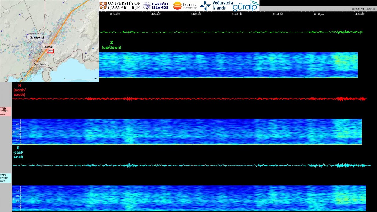
Live data from a seismic monitoring station near Hagafell — the spot experts think the volcanic eruption is most likely to take place — is showing current earthquake activity, which may indicate if magma is moving closer to the surface for an eruption to take place.
It is just a small sample of the tens of thousands of earthquakes that have occurred along a stretch of the Reykjanes Peninsula in recent weeks.
The feed, from the University of Cambridge Volcano Seismology Group, shows earthquakes being recorded at the Melhóll seismic station, which sits almost directly above the magma dike. Waves show the three axes of the seismograph: up/down, north/south and east/west motions.
While an eruption could take place anywhere along the dike, the most likely spot for an eruption appears to be around Hagafell, about 1.2 miles (2 km) north west of Grindavík, according to the IMO.
'It may take more time': Risk of eruption from Iceland volcano still high, with ground 'continuing to swell'

A sinkhole in the town of Grindavík that appeared on Nov. 18, 10 days after the town was evacuated.
The risk of a volcanic eruption on Iceland's Reykjanes Peninsula is still very high, with ground deformation and earthquakes continuing along the magma dike — a near-vertical underground tunnel running from a magma chamber towards Earth's surface.
In an interview with mbl.is the same day, Benedikt Gunnar Ófeigsson, head of deformation measurements at the IMO, said the risk of eruption may slowly be decreasing. "If we look at the conditions in the magma tunnel, maybe the probability of eruption is slowly decreasing," he said. "But it is far too early to rule out that possibility."
Activity at the magma system would need to cease for the eruption risk to be lowered. And this is not the case.
"I don't think that the risk of an eruption is starting to fall," Bill McGuire, emeritus professor of Earth sciences at University College London in the U.K, told Live Science in an email. "In fact, GPS data show that the ground surface in the vicinity of the fracture is continuing to swell, which is likely caused by the continued emplacement of magma at shallow depths. In addition, hundreds of earth tremors are still happening every day."
Edward W. Marshall, a researcher at the University of Iceland's Nordic Volcanological Center, also said the risk of eruption is still high. "In Grindavík now, it is less than two weeks since dike injection," Marshall told Live Science in an email. "So it may take more time. The point is that the soonest possible scenario that an eruption would be designated 'unlikely' is in a week or two. But I think this episode will more likely go on longer."
Editor's note: A previous version of this post attributed McGuire's quotes to another scientist.
Icelandic authorities consider pumping water to control lava flow in case of eruption
Icelandic authorities have announced they are considering plans to pump water onto the lava in the event of a volcanic eruption on the country's southern Reykjanes Peninsula. This could help cool down the lava flow and control its forecasted spread towards the town of Grindavík, which was evacuated on Nov. 10. The method could also aid in protecting important infrastructure at risk from the imminent eruption, representatives told Agence France-Presse (AFP).
"An assessment technical team will arrive in Iceland tonight or tomorrow morning and they will assist us in assessing the possibilities," Víðir Reynisson, Iceland's head of civil protection and emergency management, told AFP on Wednesday (Nov. 22).
A high volume water pump was successfully used in 1973 to manage the spread of lava that erupted from a fissure on the island of Heimaey, off the southern coast of Iceland.
"This dike has been slowly expanding in the last week but has not reached the surface yet," Pȧll Einarsson, an emeritus professor of geophysics at the University of Iceland, told Live Science in an email. "It is by no means certain that it will result in an eruption, but the possibility must be considered, in particular because the dike lies underneath the town of Grindavík."
Fewer earthquakes have been recorded in recent days compared to when the risk of an eruption was first announced, according to the Icelandic Meteorological Office (IMO). But "weather and waves continue to affect the sensitivity of the system to detect the smallest earthquakes," IMO representatives wrote in the translated statement on Wednesday. "As deformation, seismic activity, and inflow into the magma tunnel continue to decrease, the likelihood of an eruption decreases over time."
The likelihood of a sudden eruption within the town limits of Grindavík is now considered low, they added. It is unclear when residents will be allowed to return.
Risk of eruption appears to be decreasing
The risk of a volcanic eruption on Iceland's Reykjanes Peninsula now appears to be decreasing, according to the IMO. In a translated statement, representatives wrote that seismic activity in the region has continued to decrease since Nov. 20. And while ground deformation is still being recorded around the Svartsengi power plant, it is slowing. The inflow of magma to the dike is also decreasing.
Since midnight on Friday (Nov. 24), around 300 earthquakes have been recorded near the magma dike, with most smaller than magnitude 1.
The fall in seismic activity, magma inflow and ground deformation means the likelihood of an eruption is decreasing, representatives wrote.
"If magma inflow into the dike stops or reduces significantly, the dike will slowly cool down, crystallize and solidify at depth," Alberto Caracciolo, a researcher at the University of Iceland's Institute of Earth Sciences, told Live Science in an email. "A dike with no inflow of fresh magma would solidify in a few days. It is possible that the dike is currently slowly solidifying, hence the [smaller] number of earthquakes."
Iceland volcano erupts as thousands of people evacuate
The Iceland volcano is now erupting after weeks of earthquakes rocking the region, according to a statement released by the Iceland Met Office on Monday (Dec. 18).
The eruption is happening on the country's southwestern Reykjanes peninsula. About 4,000 people were evacuated from Grindavik, a fishing town village on the peninsula, and authorities also closed the town's Blue Lagoon geothermal spa, according to Reuters.
"An eruption has started north of Grindavík," according to the Met Office's statement. "It can be seen on webcams and seems to be located close to Hagafell, about 3 km [1.8 miles] north of Grindavík. The eruption began at 22.17 [5:17 p.m. EST Eastern Time] following the earthquake swarm that started around 21."

Local residents were able to watch smoke billow out from the eruption just north of Grindavík as lava colored the night sky orange.
Volcano opens up fissure that stretches 2.5 miles

An Icelandic hazard assessment map posted on Dec. 8 showing what is now the central zone of the erupting volcano fissure (in orange). (Image credit: IMO)
The volcano erupting on the Reykjanes peninsula in Iceland has opened a 2.5-mile-long (4 kilometers) fissure, officials say.
The northern end of the fissure is located just east of Stóra-Skógfell and its southern tip extends to a point just east of Sundhnúk, which sits less than 2 miles away from Grindavík, the Icelandic Met Office (IMO) said in a translated statement on Tuesday (Dec. 19).
"The power of the eruption that started about four hours ago seems to be decreasing," IMO representatives wrote in the statement. "The fact that the activity is already reducing is not an indication of how long the eruption will last, but rather that the eruption is reaching equilibrium. This trend has been seen at the beginning of all the eruptions on the Reykjanes Peninsula in recent years."
Volcanic fissure has now stabilized
The earthquakes have now died down, suggesting the fissure has stabilized with a "curtain" of magma erupting from it.
"The eruption rate is likely to be in the region of a few hundred cubic metres of lava per second — enough to fill an Olympic swimming pool in about 20 seconds," David Pyle, a professor of Earth sciences at the University of Oxford in the U.K., told Live Science in an email. "The length of the fissure may be an indication of how much magma had been able to accumulate in the crust over the past few weeks."
It's likely the eruption will continue for some days, Pyle said.
Eruption diminishes as fissure contracts

A satellite image acquired in the early hours of Tuesday (Dec. 19) shows the new eruptive fissure (yellow line) and lava flow (colored area).
The size of the eruption on Iceland's Reykjanes peninsula continues to diminish, with little activity recorded at the southern end of the newly opened fissure.
"The lava flow is estimated to be about one-quarter of what it was at the beginning of the eruption on 18 December, and a third of the original fissure is active," IMO representatives said in a statement. A curtain of lava erupting from the 2.5-mile-long fissure has also decreased in size compared to its peak height of 100 feet (30 meters) at the start of the eruption, the statement said.
Less than 24 hours have gone by since the start of the eruption, but the fissure may already be contracting to form individual vents. Five such vents have been identified, representatives said, with lava mainly flowing east toward Fagradalsfjall. The direction of the lava flow is shown in the map above, which is based on satellite images taken in the early hours of Tuesday.
Breathtaking photos show wall of lava
The seismic activity on Iceland’s Reykjanes Peninsula finally erupted in spectacular fashion on Monday (Dec. 18), when a fissure stretching 2.5 miles (4 kilometers) appeared at the surface and spewed a wall of lava up to 100 feet (30 meters) high in some places.
The initial eruption saw huge quantities of molten rock released into the surrounding landscape, with shades of orange and red filling the skies while glowing lava crept across the rocky landscape. These have been captured in incredible photos taken since the volcano erupted, a selection of which can be seen below.
For more, check out our gallery featuring even more pictures of the Iceland volcano.

The eruption in Iceland began on Dec. 18 after weeks of unrest.

People view the volcano in south west Iceland, which has erupted after weeks of intense earthquake activity.

The town of Grindavík, pictured here, is around 1.8 miles from the erupting volcano.
"Tongue of lava" is flowing to the west

Current hazard map showing the areas at risk from the Iceland volcano (in Icelandic)
The eruption at Sundhnúkagígar is ongoing, with lava spewing from two of the original five craters that emerged Monday, according to a translated statement from the IMO on Wednesday. The most active of these two is the southernmost crater.
As well as flowing to the east, a "tongue of lava" is also flowing to the west. In total, the lava bed that has formed covers an area of 1.4 square miles (3.7 square kilometers). Over the last 24 hours, 80 small earthquakes have been recorded — a significant decline compared to the days and weeks leading up to the eruption.
A new hazard map released by the IMO on Tuesday (Dec. 19) shows the regions at risk from the lava flowing from a volcanic fissure that appeared Monday (Dec. 18). The eruption, which began at Sundhnúksgígar at 10:17 p.m. local time, followed an intense earthquake swarm that shook the ground just over an hour earlier.
While IMO representatives said the eruption is weakening, the risk posed by the lava continues. The latest hazard map added two new areas to the danger zone. The areas in purple show the area where the fissure appeared. To the left, the area around the Svartsengi power plant and Blue Lagoon resort are at risk of cracks appearing and lava flows, while Grindavík, in the red zone to the south, is also at risk from hazardous gas, earthquakes and lava.
"Hazards are only assessed within these areas, but hazards may lurk outside them," representatives wrote in a translated statement. "Conditions inside and outside the areas are subject to change at short notice."
According to the IMO, there is a continued risk of further eruptions at the original fissure, and to the north and south.
Risk of sudden eruption near Grindavík diminished
The likelihood that a volcanic fissure on Iceland's Reykjanes Peninsula will give rise to a new eruption near the small fishing town of Grindavík has decreased, along with the risk of new lava flows, according to the Icelandic Meteorological Office (IMO).
"In the last 24 hours, the highest activity in the eruption has remained around the middle of the fissure that opened on 18 December," IMO representatives said in a statement on Wednesday. Seismic activity has been relatively steady since the eruption began on Monday, they said, and ground deformation around the fissure has remained minimal.
A hazard assessment map released on Wednesday drew a red zone around Grindavík, meaning the town was at risk from hazardous gas, earthquakes and lava. But the risk of new eruptions has decreased and lava flows from the fissure's craters now seem to have ceased.
"The activity appears to have diminished late last night or very early this morning," representatives said on Thursday. "However, it is still possible that lava is flowing in closed channels, so it is premature to declare the eruption over."