A new series of before-and-after images shows the ongoing flooding in Nebraska in jaw-dropping detail.
The images, created by the European Union's Earth-observation program, Copernicus, show rivers turned to lakes and farms and towns underwater. The record flooding is the result of a "bomb cyclone" that struck the central U.S. last week. The term refers to a storm that forms outside of the tropics in which atmospheric pressure drops very rapidly.
In Nebraska, snowmelt and rains associated with the storms have swollen rivers and creeks. According to the National Weather Service office in Hastings, Nebraska, at least six river gauges have recorded their highest levels ever. North of St. Paul, Nebraska, for example, a gauge on the North Loup River recorded a level of 12.6 feet (3.8 meters), breaking a record of 9.6 feet (2.9 m) set in 1947. National Weather Service personnel in the town of Valley, near Omaha, had to abandon their offices on Friday (March 15) due to flooding. [Earth from Above: 101 Stunning Images from Orbit]
Satellite imagery shows the extent of the damage. The European Space Agency's Sentinel-2 satellite collects imagery from across all of Earth's land and coastal regions every five days. Scientists with Copernicus EU compared photos taken March 16 with photos taken Feb. 4, before the rivers rose.
The satellites had a clear view of the confluence of the Elkhorn and Platte Rivers, which meet just west of Omaha. Valley, the site of the National Weather Service offices, sits between the two rivers. In February, the Elkhorn appeared as a thin, snaking line, comfortably distant from the broader Platte. As of March 16, the two rivers had practically merged in places, inundating large areas of buildings and farmland.
Flooding is widespread throughout the state: States of emergency have been declared in 56 cities, 56 counties and four tribal areas.
Record-breaking waters
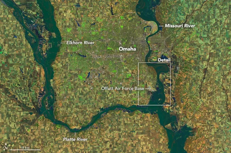
One-third of Offutt Air Force Base in Nebraska was flooded.
(Image credit: NASA Earth Observator)
While the flooding continues, most of the state has seen its highest waters. The Elkhorn River crested the day Sentinel-2 took these images, hitting a record-breaking 24.6 feet (7.5 m) at Waterloo, Nebraska. The previous record, set in 1962, was 19.1 feet (5.8 m). The Platte River crested at Louisville at 13.75 feet (4.2 m) over the weekend, according to the National Weather Service, breaking the 1960 record of 12.4 feet (3.8 m).
Sign up for the Live Science daily newsletter now
Get the world’s most fascinating discoveries delivered straight to your inbox.
Flooding continues along much of the Missouri River, which crested at 40.62 feet (12.4 m) at Plattsmouth over the weekend and remains at 38.48 feet (11.7 m) as of today (March 18). That puts the river at 12.48 feet (3.8 m) above flood stage.
A water gauge at the Spencer Dam on the Niobrara River just south of the South Dakota border went dark on Thursday (March 14) after the dam failed, sending an 11-foot-high (3.4 m) wave of water downriver, the Lincoln Journal-Star reported. The water washed away multiple buildings downstream, carried away bridges, severed pipelines and swamped wells, leaving many communities without clean drinking water.
Stephanie Pappas is a contributing writer for Live Science, covering topics ranging from geoscience to archaeology to the human brain and behavior. She was previously a senior writer for Live Science but is now a freelancer based in Denver, Colorado, and regularly contributes to Scientific American and The Monitor, the monthly magazine of the American Psychological Association. Stephanie received a bachelor's degree in psychology from the University of South Carolina and a graduate certificate in science communication from the University of California, Santa Cruz.