A new, unforgettable image is revealing how water flows through every river basin in the United States.
The stunning visualization follows the path of blue gold throughout the country. Surprisingly, no area is too far from the path of water. For instance, the arid Southwest may go months without significant rainfall, yet most of the region is threaded by hundreds of rivers fanning out from the Upper and Lower Colorado Rivers.
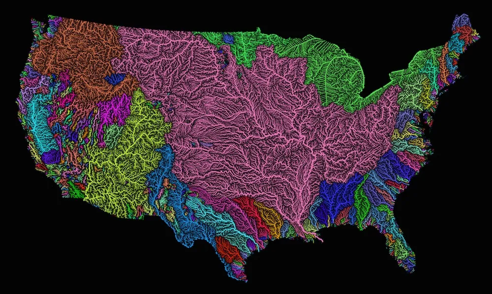
The new map was created by geographer Robert Szucs, who goes by the username Fejetlenfej on the image curation site Imgur. Szucs created the map using open-source mapping software and publicly available data.
Latest Videos From
The new image shows the flow of different river systems in different colors. For instance, the Mississippi and Missouri rivers, which meet up near St. Louis, Missouri, are painted pink, while the Colorado River shows up in vibrant yellow. The Pacific Northwest river basin in the United States is fed by two major rivers — the Columbia and the Snake — both of which originate in Canada. Thicker arterials represent major rivers, while the thinner lines depict minor streams, rivers and tributaries.
The striking image also reveals that the vast majority of the Midwest and much of the Mountain West are threaded with streams, rivers and tributaries that fan out from the Missouri and the mighty Mississippi. The Missouri River is the longest river in North America, while the second-longest, the Mississippi holds the most water. The Mississippi meanders 2,350 miles (3,781 kilometers) from Lake Itasca in Minnesota before emptying into the Gulf of Mexico (The Missouri River is longer). At Lake Itasca, the river is less than 30 feet (9 m) wide, but it sprawls 11 miles (17 km) across near Lake Winnibigoshish in Minnesota, according to the National Park Service.
By contrast, the coastal regions look like a patchwork of smaller river networks. For instance, waterlogged Florida is threaded by dozens of smaller rivers, such as the Ocklawaha, the St. Lucie, the Kissimmee and the Miami.
Rivers play a key role in providing water to humans, both through above-ground reservoirs and groundwater reservoirs hidden deep underground.
Szucs is also selling the images on his Etsy site.
Original article on Live Science.

 Live Science Plus