 Live Science Plus


Ancient Roman ruins that lie hidden below the surface at the Apennine Mountains of Italy have largely escaped discovery because the rugged terrain makes them difficult to spot by foot and dangerous to find by airplane.
Now, using small airborne drones, archaeologists have found that an ancient settlement in the Apennines was much more dense and organized than previously thought, a new study reveals. The study offered evidence that dronescould help uncover more unknown sites in mountains worldwide.
Article continues below"The way this mountain society was organized remains poorly understood," said study author Tesse Stek, a Mediterranean archaeologist at Leiden University in the Netherlands.

Previously, construction accidentally unearthed two ancient temples in the area. However, "there was no good knowledge about other sites, such as villages, farms, villas, graveyards and so on, that could tell us more about the ancient inhabitants in the area that visited the cult sites," Stek told Live Science. "They seemed to be cathedrals in the desert, so to say." [5 Surprising Ways Drones Could Be Used in the Future]
One theory is that these temples served as road stations and places of commerce along routes where sheep, cattle, goods and information traveled. Another theory suggests that these temples marked the frontier of a large state, such as the territory of the ancient Samnites.
Looking for hidden ruins
Archaeologists might want to conduct aerial surveys to help discover any ruins hidden beneath the surface. These require slow, low-altitude flights where researchers can take pictures of sites from the right angles and with the right lighting reveal ancient complexes.
For instance, on farmland, ancient walls may present themselves "as stripes where the grain is lower," Stek said. "Sometimes this is hard to see from a distance, but it becomes especially visible when the sun is low, and shadow effects enhance the differences in corn height."
However, in rugged terrain, "flying low is very difficult, dangerous, and time-costly," Stek said. "In the mountainous, fragmented area where we work, previously normal aerial archaeology had not had success.
"Drones now change the picture completely," Stek said. "They offer a fast and entirely noninvasive method for discovering and mapping sites hidden in the ground." [Photos: Drones Explore Mysterious Plain of Jars Site]
In 2013, 2014 and 2015, the researchers investigated Le Pianelle using small commercial DJI Phantom quadcopter drones with cameras capable of taking photos both downward and from the side. The scientists remotely programmed the drones with flight plans to examine areas where researchers had discovered artifacts on foot.
The main advantage of using drones "is that you can choose very precisely which angle to take photos at the time you want," Stek said. "You can wait for the exact right moment in a specific field, make a flight of, say, 10 to 20 minutes' length, and take photos from all directions. With a normal airplane, you would need to be very lucky to catch the right moment, or you'll fly too high for good visibility or resolution, or the moment may not be right."
Revealing Le Pianelle
The elements made drone-flying difficult at times. "We actually lost one drone during a long, automated flight due to strong winds in a narrow valley," Stek said.
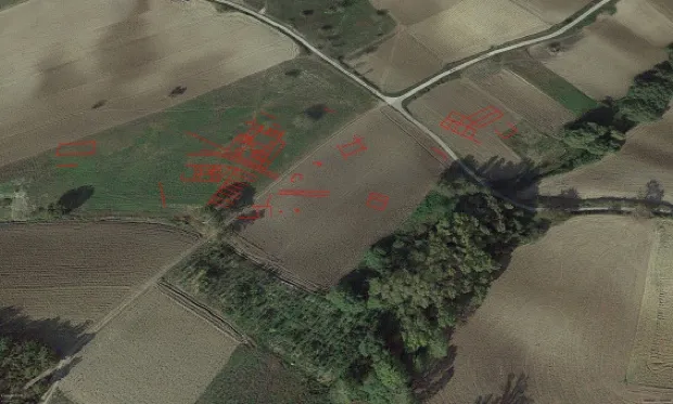
Despite such challenges, the drones helped reveal what appear to be the remains of several likely related archaeological complexes. "I could not believe it at first, but as they showed up on the computer screen at our base camp, the whole team started to yell, 'Wow!'" Stek said. [Incredible Drone Photos: Contest-Winning Images from Above]
Artifacts previously found in the area suggest these ruins date from the Classical to Late Roman period spanning from about the fifth century B.C. to the seventh century A.D. The researchers found that settlements at Le Pianelle were "much more dense, organized and articulated than previously thought," Stek said.
"We have a very complete overview of the internal organization of the settlement, including its disposition along the road, storage spaces, domestic areas and so on."
These new findings suggest the temples that were previously discovered in this area were not located away from civilization, but were rather "actually located at the center of dense, rural communities," Stek said.
Drones will not replace traditional archaeology, Stek emphasized. "If you do not see anything on drone footage, it does not mean that there is nothing underneath," he said. "There are many different factors influencing the detectability of sites by drones, so other types of research, such as field surveys, geophysics and excavations, remain fundamental, too."
The scientists are talking with local authorities to excavate these sites. "Protecting the site from damage from agricultural use and robbing is the first priority now," Stek said.
Stek added that in the spring, "I plan an aerial campaign in which we aim to investigate a large swath of territory in two weeks." In addition, the scientists are experimenting with near-infrared cameras to detect even more hidden details, "with very good results," Stek said.
Stekdetailed his findings online July 4 in the Journal of Cultural Heritage.
Original article on Live Science.

