It's quick and easy to access Live Science Plus, simply enter your email below. We'll send you a confirmation and sign you up for our daily newsletter, keeping you up to date with the latest science news.
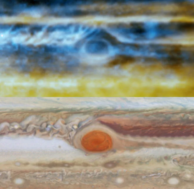
A new radio map of Jupiter, built with data from the Very Large Array in New Mexico, shows the movement of ammonia gas in the planet's atmosphere. Here, new radio measurements (above) are compared with a visible-light map from Hubble Space Telescope images, in approximate true color.
(Image credit: Michael H. Wong, Imke de Pater (UC Berkeley), Robert J. Sault (Univ. Melbourne). Optical: NASA, ESA, A.A. Simon (GSFC), M.H. Wong (UC Berkeley), and G.S. Orton (JPL-Caltech))
Just one month before the Juno spacecraft arrives at the gas giant Jupiter, the most detailed radio-wave maps ever of the planet's atmosphere dig beneath surface-level clouds to reveal the whirling ammonia flows that help form its distinctive features.
Researchers used the upgraded Very Large Array (VLA) radio telescope in New Mexico to probe 60 miles (100 kilometers) below the top of the gas giant's pervasive clouds — revealing a correlation between the colorful whirls and spots on the visible surface and the movement of gas below, which is driven by Jupiter's internal heat source.
"We in essence created a three-dimensional picture of ammonia gas in Jupiter's atmosphere, which reveals upward and downward motions within the turbulent atmosphere," Imke de Pater, an astronomer at the University of California, Berkeley, and lead author on the new work, said in a statement. [Amazing Photos of Jupiter and Its Many Moons]
Transition from optical image of Jupiter to new radio map; many of the same features are visible. In the radio view, rising ammonia-rich gases are dark and sinking, ammonia-poor gases are bright. Clouds of condensed ammonia are not visible by radio.
(Image credit: Radio: Robert J. Sault (Univ. Melbourne), Imke de Pater and Michael H. Wong (UC Berkeley). Optical: Marco Vedovato, Christopher Go, Manos Kardasis, Ian Sharp, Imke de Pater.)
Those maps reveal more detail than any previous radio map, spotting features just 800 miles (1,300 km) across, UC Berkeley officials said in the statement.
The researchers saw that ammonium-rich gases rose to form the upper cloud layers — ammonium hydrosulfide at about 200 Kelvin (minus 100 degrees Fahrenheit) and a cloud of ammonia-ice at 160 K (minus 170 degrees F), both of which can be seen with optical telescopes, officials said in the statement. The map also revealed gases with less ammonia sinking back down into the planet.
The areas with less ammonia, spread in a broad band around the planet, seem to correlate with "hot spots" on the planet's surface — areas that researchers have pinpointed as particularly bright in radio and infrared images. Those "hot spots" appear as holes in the planet's cloud cover, and look hazy in optical light.
"With radio, we can peer through the clouds and see that those hotspots are interleaved with plumes of ammonia rising from deep in the planet, tracing the vertical undulations of an equatorial wave system," Michael Wong, an astronomer who is also at UC Berkeley, said in the statement.
Sign up for the Live Science daily newsletter now
Get the world’s most fascinating discoveries delivered straight to your inbox.
A new radio view of Jupiter at three wavelengths: 2 cm in blue, 3 cm in gold and 6 cm in red. Researchers created this image from 10 hours of data, averaged, so instead of fine detail the features are smeared by the planet's rotation. The pink glow comes from radiation caused by electrons trapped in Jupiter's magnetic field.
(Image credit: Imke de Pater, Michael H. Wong (UC Berkeley), Robert J. Sault (Univ. Melbourne))
To build the new map, the researchers observed the many different wavelengths of radio waves emitted by the planet's atmosphere over time. While visible-light telescopes can get back images from the surface quickly, the VLA radio telescope has to observe for multiple hours. The telescope's upgraded sensitivity, combined with new data-processing algorithms, let the researchers unblur the smeared images that are made by the fast-moving planetary atmosphere. Those images can be combined with the Hubble Space Telescope's visible views of the planet and others to get a fuller view of the environment.
"We now see fine structure in the 12- to 18-gigahertz band, much like we see in the visible, especially near the Great Red Spot, where we see a lot of little, curly features," Wong said, referring to the massive storm on Jupiter's surface that's two times Earth's diameter. "Those trace really complex upwelling and downwelling images there."
On July 4, NASA's Juno spacecraft will reach Jupiter and begin studying its weather, composition and magnetic environment before diving down through the planet's deep atmosphere. These new Jupiter maps will help researchers fit those findings into the bigger picture of the planet.

 Live Science Plus