


Weather Fronts: Definition & Facts
A weather front is a term used in meteorology to describe the front end or advancing edge of an air mass that will soon replace the air mass that’s over a specific region. These air masses are designated P for “polar” (cold), T for tropical (warm), M for maritime (wet) and C for continental (dry).
The NOAA Central Library U.S. Daily Weather Maps Project is an interesting and potentially valuable weather resource for researchers. The website provides access to historical daily weather maps from 1871 thru 2003. Virtually every weather government map that was published during that 132 year time span — more than 48,000 of them — are available here. If you were to check out the maps that were published prior to Aug, 1, 1941, you might notice that something was missing. There were no weather fronts plotted!
In 1919, Jacob Bjerknes, son of a noted Norwegian meteorologist, Vilhelm Bjerknes, announced his discovery of air masses and fronts. Prior to that, it was thought that if today happened to be colder, it was simply yesterday’s air with some heat that was lost to space. Or if today turned out to be warmer, then it was assumed that it was yesterday’s air with some heat added in. But Bjerknes realized that there were masses of colder and warmer air that swept across the globe and bumped into each other and in the process produced zones of unsettled weather near and along their respective boundaries.

More than two decades would pass before frontal lines were incorporated into the daily weather map. But exactly what are they and what type of weather might they be expected to produce?
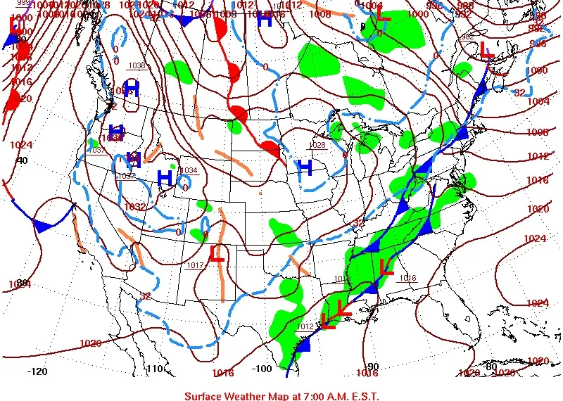
Cold fronts
Cold fronts are marked on weather maps with the symbol of a blue line of triangles/spikes (pips) pointing in the direction of travel, and are placed at the leading edge of the cooler air mass. That cold/dense air wedges its way under the warm air out ahead of it.
Cold fronts are very much like atmospheric plows, pushing away warm, moist air and replacing it with a cooler and drier air mass. Another good metaphor for a cold front is that it’s like a hand plane. When the cutter or sharpened metal plate is pushed forward over a wood surface it slices shavings of wood that curl upward in advance of the cutter. With the cold front, warm air is rapidly forced upward (like the shavings) in advance of the actual front (the “cutter”), creating towering cumulus clouds, some hard showers and quite possibly a few gusty thunderstorms followed by a push of cooler and drier air in its wake.
In some cases, there doesn’t seem to be much of a difference temperature-wise between the air ahead of a cold front and the air moving in behind it; so it’s not so much the difference in temperature as is the difference in terms of a moist and humid air mass being displaced by a significantly drier and less humid air flow. Then we might speak of the frontal boundary not so much as a “cold” front as opposed to representing a “dry” front.
Get the world’s most fascinating discoveries delivered straight to your inbox.
Cold fronts generally advance at average speeds of 20 to 25 mph. toward the east — faster in the winter than summer — and are usually oriented along a northeast to southwest line. Winds out ahead of a cold front tend to blow from the south and southwest, and then shift after the frontal passage (called a “fropa” by meteorologists) into the northwest.
But on occasion, a cool air mass might build up over eastern Canada and sink southward through northern New York and New England. The result is a cold front that advances toward the west and south. Such a scenario is called a “back door” cold front and usually occurs during the spring and summer months. In the spring, when many are yearning for milder temperatures to take hold, a back door front is looked upon as set-back, with temperatures falling from unseasonably balmy levels back to chilly or even cold levels. Conversely, in the summer, back door fronts can be a welcome change, as a sweltering heat wave can suddenly be brushed aside as front coming in from the north or northeast ushers in a cool, refreshing breeze.
Warm fronts
Warm fronts are marked on weather maps with a red line of half circles pointing in the direction of travel and mark the edge of an advancing warm air mass; a flow of warmer air that overtakes and replaces colder air. They are usually found on the east side of low-pressure storm systems. Since the cold air is denser than the warm air, the cold air hugs the ground. The lighter warm air slides up and over the cold air (called “overrunning”) and lacks any direct push on the cold air. Thus, the cold air is slow to retreat in the rapid advance of the warm air. This slowness of the cold air to retreat produces an atmospheric slope that is more gradual than the sharper slope that accompanies a cold front.
The sensible weather associated with a warm front can stretch for as much as a thousand miles out ahead of it and as much as 36 to 48 hours prior to its actual arrival. Increasing moisture ahead of the warm front first arrives in the high levels of the atmosphere in the form of thin, wispy cirrus (ice crystal) clouds. You might even catch sight of a halo around the sun or moon; sailors would interpret this as a sign that weather was likely to turn unsettled within the next 18 to 24 hours. And indeed, with the passage of time, these thin clouds gradually lower and thicken and eventually a steady light rain or drizzle will start to fall. Near the actual frontal boundary, precipitation tends to become steadier and heavier and there could also be areas of fog as well.
Warm fronts are seldom as well marked as cold fronts, and they usually move about half as fast, at about 10 to 15 mph, and sometimes even slower. This is why precipitation associated with warm fronts is, generally speaking, of a long duration.
And especially during the winter months, the cold air that a warm front is attempting to displace is often heavy and dense and is stubborn to dislodge. As a result, the shape of some warm fronts end up contorted, seemingly looping around the colder air mass.
Stationary fronts
Stationary fronts are depicted by alternating red half-circles and blue spikes (pips) pointing in opposite directions, indicating no significant movement. When neither air mass is replacing the other, the frontal boundary becomes more-or-less stationary; the opposing forces exerted by adjacent air masses of different densities are such that the frontal surface between them shows little or no movement (sometimes also referred to as a “quasi-stationary” front). In such cases, the surface winds tend to blow parallel to the frontal zone. The resultant weather is usually low cloud cover and long duration precipitation, and not much in the way of wind.
Should the front “buckle,” a wave of low pressure could develop on the front and then ripple along it to the east or northeast. Sometimes more than one wave of low pressure develops along the front, while on other occasions; a singular wave of low pressure will form and then strengthen as moves off to east or northeast, taking the trailing end of the front right along with it.
Occluded fronts
Cold fronts almost always travel faster than warm fronts and eventually they catch up to it. When this happens the warm air is forced up away from the ground, and their associated low pressure system is said to be occluded. The point of occlusion is also known as the “triple point” out of which extends a cold front to the south, a warm front extending to the east and the occluded front, which extends north back to the center of low pressure.
Storm systems usually reach their greatest intensity when they first become occluded; they then begin to weaken gradually over the next few days as the air in the storm ‘mixes up,” the differing air masses and the temperature contrasts are destroyed. This deprives the storm of its energy source, and so it ultimately dies. Occluded frontal passages are usually marked gusty winds and bouts of heavy rain, perhaps even thunderstorms. They are marked on the weather map by a purple line with alternating half-circles and triangles pointing in their direction of travel.
Troughs
Finally, a trough (pronounced “trof”) is an elongated region of relatively low atmospheric pressure, often associated with fronts that can occur either at the Earth's surface or at higher altitudes. Air pressure is lower along the axes of the trough than on its two sides. Sometimes, the isobars with a trough have a pronounced V-shape. Active weather fronts always lie within troughs, but not all troughs are frontal. The passage of an upper level trough might make its presence felt by producing a build-up of clouds, followed by a quick shot of precipitation, then clearing skies.
Unlike fronts, there is no universal symbol for a trough on a weather chart. In the United States, for instance, a trough is delineated by a black dashed line. In Great Britain, it is depicted by a bold line extending from a low pressure system, while in Australia it’s a dotted line.
For the Latest Information on Weather, Visit:
