













GPS Could Issue Tsunami Alert in Minutes

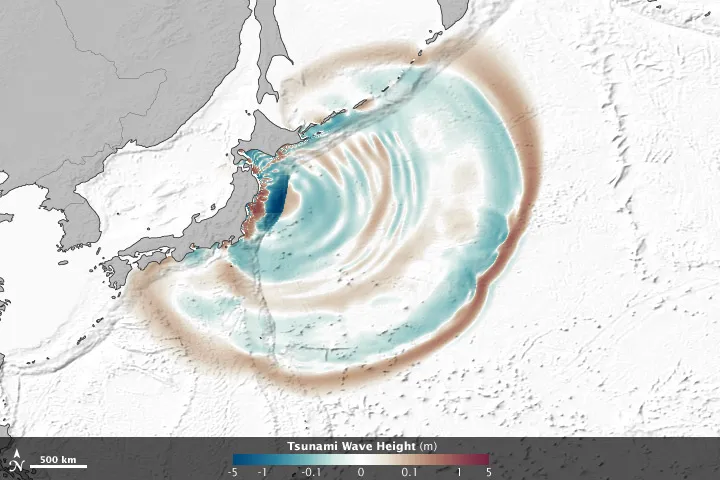
The global positioning system (GPS) — the same system that helps people navigate unfamiliar places — could also serve as an early-warning system for tsunamis, according to new research.
When a magnitude-9.0 earthquake struck Japan on March 11, 2011, coastal residents received an inaccurate estimate of the earthquake's magnitude before the waves hit and leveled thousands of buildings.
The area under alert was warned based on an estimated earthquake magnitude of 7.9 — 130 times less intense than the actual quake was — meaning fewer neighborhoods were evacuated in response to the perceived threat.
Researchers behind a new study have said that GPS systems along the coast could have given the residents a better warning. Sifting through the GPS data from stations along the coast and issuing a more accurate tsunami alert based on that data would only have taken three minutes, the study found. [7 Ways the Earth Changes in the Blink of an Eye]
Subduction zones and GPS
Most tsunamis occur when one tectonic plate slides underneath another and causes an earthquake. In the process, the top plate is forced upward, and this uplift of the seafloor pushes on the water above it, setting off the tsunami. How high the ground rose on the seafloor would influence wave heights up on the surface.
The coast also slightly rises or falls along with the ocean floor, making it possible to see these changes through coastal GPS stations. Therefore, areas near these so-called subduction zones can be mapped and measured using GPS to see how much the ground has shifted and in what way it has deformed.
Get the world’s most fascinating discoveries delivered straight to your inbox.
Whereas traditional seismological stations are located some distance away from the source, GPS transmitters can be placed much closer, on the coastline, to where the tsunami occurred, buying valuable time for those looking to escape.
"To really get absolute values of slip, you would need to have stations at the seafloor," said Andreas Hoechner, a postdoctoral researcher at the GFZ German Research Centre for Geosciences in Potsdam.
"However, [the coastal GPS readings are] good enough to get good tsunami wave estimates."
A subduction quake makes several ocean waves: crest waves on top of the seafloor that rise, and trough waves on the seafloor that drop down. Additionally, independent research has recently showed that a shoreline's features also influence the severity of a tsunami's impact on land.
Reconstructing an alert
To reconstruct what a GPS alert would have looked like during the 2011 temblor, the scientists took information from the Japanese GPS Earth Observation Network (GEONET) the day before, the day of, and the day after the 2011 earthquake. The station is typically used for long-term changes to the ground, such as "relaxation processes" between earthquakes, but has not been applied yet for tsunami warnings, Hoechner said.
While Japan has about 1,200 of these stations, the researchers only used 50 of them in order to take less time to issue an alert. The exact number of stations does not matter in this scenario, Hoechner noted, as long as there are enough to note a rapidly changing height difference between the ground on the coast and the ground further inland.
GPS stations provide more accurate information about ground shifts than seismological stations do, as seismological stations are better suited for looking at the amount of ground shaking — rather than shifting — associated with an earthquake. Both systems are useful in their own ways and should be used together, Hoechner said.
In the case of Japan’s Tōhoku earthquake, a tsunami warning issued just three minutes after the earthquake struck would have provided several minutes for people to scramble to safety. Tsunamis typically hit land about 20 to 30 minutes after they are generated, Hoechner said, depending on the distance between land and the earthquake's epicenter.
The challenge will be to actually use the GPS sensors for real events, not just for simulating past tsunamis. And the technique could be used not only in Japan, but also in Indonesia. After the devastating 2004 earthquake in that region, there were some GPS stations installed, but the researchers say more are needed to make accurate tsunami warnings.
The results appear in the latest edition of Natural Hazards and Earth System Sciences, an open-access journal of the European Geosciences Union.
Hoechner's team plans to extend its research to Chile, which was the site of a devastating tsunami in 2010.
Follow Elizabeth Howell @howellspace. Follow us @livescience, Facebook & Google+. Original article on LiveScience.com .

Elizabeth Howell was staff reporter at Space.com between 2022 and 2024 and a regular contributor to Live Science and Space.com between 2012 and 2022. Elizabeth's reporting includes multiple exclusives with the White House, speaking several times with the International Space Station, witnessing five human spaceflight launches on two continents, flying parabolic, working inside a spacesuit, and participating in a simulated Mars mission. Her latest book, "Why Am I Taller?" (ECW Press, 2022) is co-written with astronaut Dave Williams.