Ernesto Brings Tremendous Flooding Risk

Get the world’s most fascinating discoveries delivered straight to your inbox.
You are now subscribed
Your newsletter sign-up was successful
Want to add more newsletters?
Join the club
Get full access to premium articles, exclusive features and a growing list of member rewards.
This article was provided by AccuWeather.com.
As Ernesto continues to move westward, the weather will go downhill rapidly in Belize and the rest of the Yucatan Peninsula into Tuesday evening.
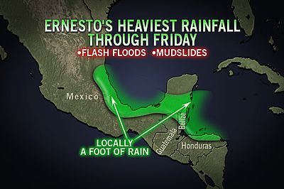
Ernesto has gathered a large field of moisture in the form of towering showers and thunderstorms, capable of unleashing a foot of rain in portions of Belize, Guatemala, northern Honduras and southeastern Mexico through much of the balance of this week.
Article continues belowRainfall rates of up to a couple of inches per hour can not only overwhelm streams and drainage systems, but lead to mudslides in hilly and mountainous areas inland of the coast including the Maya Mountains of Belize.
Coastal regions near and north of the storm center will also be significantly impacted by 10- to 18-foot waves in addition to a 1- to 3-foot storm surge. Coastal flooding will occur as a result.
RELATED LINKS:
The Worst is Yet to Come: Atlantic Hurricane Season
Get the world’s most fascinating discoveries delivered straight to your inbox.
Atlantic Hurricane Season: Record Start, Followed by a Lull
AccuWeather.com Hurricane Center
Strong wind gusts, generally in the vicinity of severe thunderstorms wrapping around the large circulation of the storm also bring the risk of damaging wind gusts at a more local level. The severe thunderstorms can occur hundreds of miles away from the center of Ernesto.
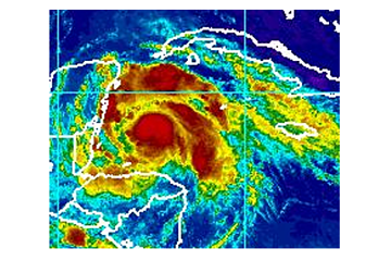
Less than 18 hours from landfall, Tropical Storm Ernesto has the potential to become a hurricane as it churns westward toward the Yucatan Peninsula.
The outer bands of the storm have been pounding Honduras since Monday with heavy rain and gusty winds.
Hurricane warnings have been issued for the entire coast of Belize and from Chetumal to Tulum on the east coast of the Yucatan Peninsula. Although Ernesto is still a tropical storm, favorable conditions could help it strengthen into a Category 1 (74 to 95 mph) prior to landfall.
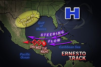
AccuWeather.com meteorologists expect the center of Ernesto to come onshore near the border of Belize and Mexico late Tuesday evening into early Wednesday morning. The storm will lash the area with at least tropical storm force winds and hurricane force wind gusts.
As Ernesto interacts with land and loses the fuel of the warm, Caribbean Sea it will weaken to over the Yucatan Peninsula. However, by late Wednesday, the storm is expected to emerge into the region of the Gulf of Mexico, known as the Bay of Campeche. Once this occurs, some restrengthening is possible.
A large dome of high pressure north of the storm should keep Ernesto on a westerly track toward Mexico and away from the U.S. A second landfall is likely near the city of Veracruz on Friday.
As far as the United States is concerned, Ernesto is expected to have little or no impact aside from some rough surf along the Texas coast.
Despite looking quite feeble over the weekend, Ernesto gained strength over the northwestern Caribbean. Warm water, lower wind shear and less interaction with the continent of South America, has allowed Ernesto to become a strong tropical storm.
Elsewhere in the Atlantic, there are no other active tropical systems. A few tropical waves are being monitored, but none show signs of immediate development.
Expert Senior Meteorologist Alex Sosnowski contributed to the content of this story.
© AccuWeather.com. All rights reserved. More from AccuWeather.com.
 Live Science Plus


