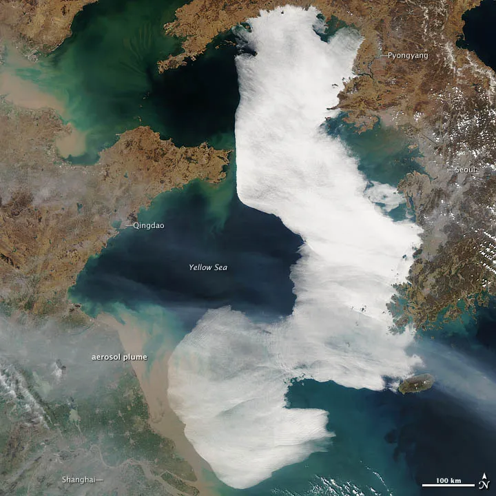
The large white patch covering the Yellow Sea in this satellite image on March 28 is a thick layer of fog, a not uncommon site in this area.
The low-lying cloud formation covered an area roughly the size of the Korean Peninsula, stretching nearly 400 miles (900 kilometers) from Korea Bay to the Chinese city of Shanghai.
The fog is generally thickest along the edges, where the cloud surface appears quite smooth in the satellite image, taken by the Moderate Resolution Imaging Spectroradiometer (MODIS) on NASA's Aqua satellite. Closer to the middle, the surface has a more textured appearance, indicating possible convection and the possible presence of stratocumulus clouds. These clouds form higher in the atmosphere than fog and do not affect visibility at the sea surface, according to a NASA statement.
Latest Videos From
An aerosol plume, likely haze emanating from industrial areas in China, is also visible and has caused the lower half of the cloud to appear slightly grayer than the upper half.
The shallow Yellow Sea usually sees 50 foggy days a year; some weather stations in the area have measured fog on up to 80 days.
Atmospheric scientists Peter Norris and Gary Partyka of NASA's Goddard Space Flight Center simulated the meteorological conditions that might create such a cloud formation and found that the fog was likely advection fog. This type of fog generally forms when warm, moist air is pushed by winds over a cooler surface. In this case, northeasterly winds pushed a tongue of warm air out over the cooler Yellow Sea.
According to research conducted by scientists at the Ocean University of China, the season for advection fog usually starts in early April and ends in August as a result of shifting regional wind patterns, NASA said. Generally the fog lasts about two days; but once in 1977, an exceptionally long-lasting fog event spanned 10 days.

 Live Science Plus