Seen from Space: Christmas Island
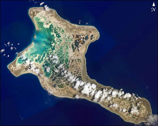
Get the world’s most fascinating discoveries delivered straight to your inbox.
You are now subscribed
Your newsletter sign-up was successful
Want to add more newsletters?
Delivered Daily
Daily Newsletter
Sign up for the latest discoveries, groundbreaking research and fascinating breakthroughs that impact you and the wider world direct to your inbox.
Once a week
Life's Little Mysteries
Feed your curiosity with an exclusive mystery every week, solved with science and delivered direct to your inbox before it's seen anywhere else.
Once a week
How It Works
Sign up to our free science & technology newsletter for your weekly fix of fascinating articles, quick quizzes, amazing images, and more
Delivered daily
Space.com Newsletter
Breaking space news, the latest updates on rocket launches, skywatching events and more!
Once a month
Watch This Space
Sign up to our monthly entertainment newsletter to keep up with all our coverage of the latest sci-fi and space movies, tv shows, games and books.
Once a week
Night Sky This Week
Discover this week's must-see night sky events, moon phases, and stunning astrophotos. Sign up for our skywatching newsletter and explore the universe with us!
Join the club
Get full access to premium articles, exclusive features and a growing list of member rewards.
From NASA's Earth Observatory:
Pronounced “Ki-ris-mas,” Kiritimati Island has a large infilled lagoon that gives it the largest land area (125 square miles, 321 square km) of any atoll in the world. Captain Cook named the atoll Christmas Island when he arrived on Christmas Eve in 1777. Used for nuclear testing in the 1950s and 1960s, the island is now valued for its marine and wildlife resources. It is particularly important as a seabird nesting site — with an estimated 6 million birds using or breeding on the island, including several million Sooty Terns. Rainfall on Kiritimati is linked to El Niño patterns, with long droughts experienced between the wetter El Niño years.
This image is based on a mosaic of four digital photographs taken on 16 January 2002 from the Space Station Alpha as part of the Crew Earth Observations Project. The underlying data have 10 meter spatial resolution. Coral reefs are one of the areas selected as a scientific theme for this project (see also the recent Earth Observatory article, Mapping the Decline of Coral Reefs.
Get the world’s most fascinating discoveries delivered straight to your inbox.

