


Ferocious Alaska Storm Spotted by Satellite
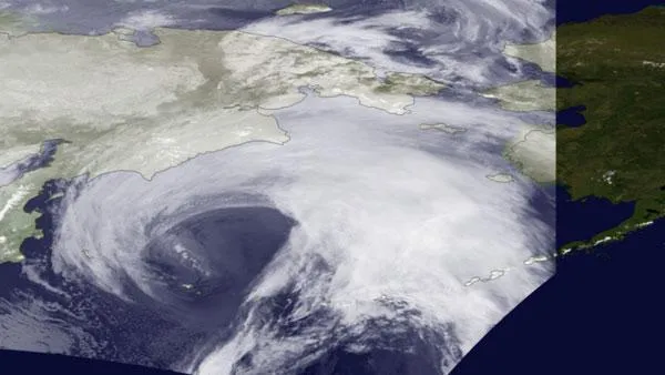
The monster storm bearing down on the west coast of Alaska was caught by the infrared sensors on board a National Oceanic and Atmospheric Administration (NOAA) satellite.
The storm is predicted to bring hurricane-force winds and high waves through the Bering Strait and along the Alaskan coast. Coastal flood warnings are in effect for much of western Alaska, and some coastal villages evacuated last night (Nov. 8), according to news reports.
"This will be extremely dangerous and life-threatening storm of an epic magnitude rarely experienced," read a statement from the NWS. "All people in the area should take precautions to safeguard their lives and property."
The storm could be one of the most severe Bering Sea storms in nearly 40 years. The storm could be similar to a 1974 storm that socked the state, but sea ice is lower in today's warmer world, providing no protection along the coast, according to the NWS.
Because of Alaska's high latitude, geostationary satellite do not provide adequate coverage. Polar-orbiting satellites like NOAA-19 are required to monitor severe weather in such areas. However, polar-orbiting satellites acquire imagery as swaths as the orbit around the planet. The area outside of the swath is visible in this image.
- Where Did the Dangerous Alaska Storm Come From?
- Hurricanes from Above: See Nature's Biggest Storms
- Weirdo Weather: 7 Rare Weather Events
Get the world’s most fascinating discoveries delivered straight to your inbox.
