


Jova's Eye 'Winked' at Satellites
Satellites have tracked now Tropical Storm Jova from its birth over the Pacific Ocean to its landfall last night over the west coast Mexican state of Jalisco as a Category 2 hurricane.
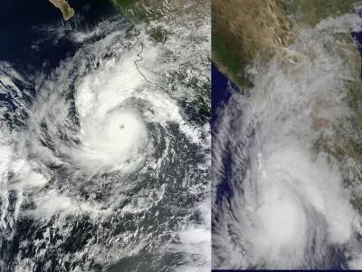
After Jova became a hurricane on Oct. 8 and before it made landfall, it fluctuated in strength, with its central eye -- an indicator of strength -- was alternately clear and cloud-covered, essentially "winking" at satellites.
In a visible image of Hurricane Jova from the Moderate Resolution Imaging Spectroradiometer (MODIS) instrument on NASA's Terra satellite on Oct. 10 at 1:40 p.m. EDT, the eye was clearly visible. A visible image from NOAA's GOES-11 satellite on Oct. 11 at 12:45 p.m. EDT showed Jova's eye "closed" (or cloud-filled).
In addition to Jova's wink, the infrared AIRS instrument on NASA's Aqua satellite got a cold stare from Jova's eye. Infrared data measures cloud top temperatures, and NASA AIRS instrument noticed they were as cold as minus 112 Fahrenheit (minus 80 Celsius) in the thunderstorms in Jova's eyewall. Those frigid cloud top temperatures indicate there's a tremendous amount of power in the storm. The colder the cloud tops, the higher and stronger they are, and Jova is very powerful. [Infographic: Storm Season! How, When & Where Hurricanes Form ]
Jova weakened into a tropical storm after making landfall, which is typical of such storms. Warm waters are one of their key fuel sources, which they are cut off from once over land.
Jova is sporting winds of 65 mph (100 kph) and is continuing its way inland; it will continue to weaken as it does so, dissipating by late Thursday or Friday. Heavy rain is a major concern with this storm, which could dump between 6 to 12 inches (15 to 30 centimeters) in some areas, with localized deluges of 20 inches (50 cm) possible.
- Hurricane Season is Past Its Peak (But Stay on Guard )
- Hurricanes from Above: See Nature's Biggest Storms
- The Costliest Hurricanes in History
Get the world’s most fascinating discoveries delivered straight to your inbox.
