It's quick and easy to access Live Science Plus, simply enter your email below. We'll send you a confirmation and sign you up for our daily newsletter, keeping you up to date with the latest science news.
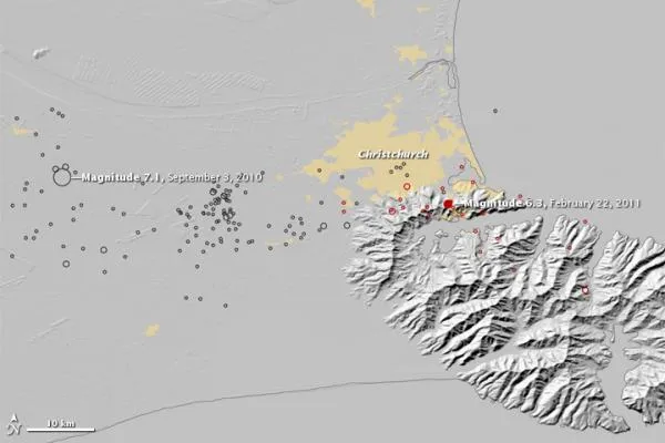
A new NASA map shows the earthquakes that have hit near Christchurch, New Zealand, since Sept. 3, 2010, when a magnitude 7.0 quake struck outside of the city.
Since then, the Christchurch region has felt many aftershocks, including yesterday's deadly temblor , a 6.3-magnitude earthquake that struck at 12:51 p.m. local time (6:51 p.m. EST Feb. 21), during the middle of a busy workday. The death toll is now at 75, according to news reports, and several hundred are reported missing. [Related: The Science Behind the New Zealand Quake .]
(Image credit: NASA Earth Observatory.)
In the above image, black circles represent earthquakes from Sept. 3, 2010, until Feb. 21, 2011. Red circles show the locations of the magnitude 6.3 quake and aftershocks on Feb. 22 and the morning of Feb. 23. Larger circles represent stronger earthquakes. Yellow shows urban areas, including Christchurch.
The U.S. Geological Survey characterized the 6.3-magnitude quake on Feb. 22 as an aftershock of the quake that struck in Darfield, New Zealand, on Sept. 3, 2010, about 25 miles (40 kilometers) to the west of Christchurch, which is New Zealand's second-largest city with nearly 400,000 residents.
Although no specific tectonic structure linked the two events, numerous aftershocks of the September quake occurred along a roughly east-west line, as this image indicates. The USGS said that the quakes were associated with regional tectonic plate boundary deformation. The Pacific Plate and the Indo-Australia Plate interact under the South Island of New Zealand (Tectonic plates are huge, moving slabs of the Earth's crust.)
The Darfield earthquake in September caused no casualties, even though it had a higher magnitude. Besides striking closer to a major population center, the 6.3-magnitude Christchurch earthquake had a depth of just 3 miles (5 km). The New Zealand Herald reported that, whereas the Darfield quake happened in the early morning hours, the Feb. 22 quake struck at the "worst possible time" of day at the lunch hour when city streets were crowded with shoppers, diners, office workers and school children. Moreover, some of the buildings that collapsed may have been weakened by the September 2010 quake.
Effects of the Christchurch earthquake were felt some 125 miles (200 km) away, along the South Island's west coast. A 33 million-ton chunk of ice broke off from the Tasman Glacier, and slid into Tasman Lake. In fact, officials had expected ice would break off the glacier, although they expected the event to result from heavy rainfall caused by La Niña.
Sign up for the Live Science daily newsletter now
Get the world’s most fascinating discoveries delivered straight to your inbox.
For the science geek in everyone, Live Science offers a fascinating window into the natural and technological world, delivering comprehensive and compelling news and analysis on everything from dinosaur discoveries, archaeological finds and amazing animals to health, innovation and wearable technology. We aim to empower and inspire our readers with the tools needed to understand the world and appreciate its everyday awe.

 Live Science Plus