Our amazing planet.

Season of Light: Urbanization in Montreal Captured

lights-montreal-110110-02
(Image credit: Expedition 26 Crew, NASA.)

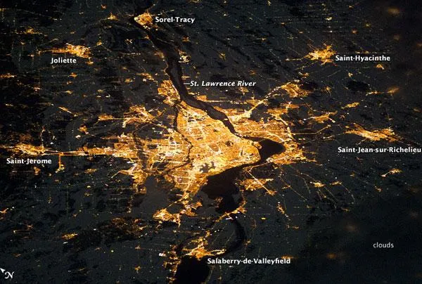
Montreal, the largest city in the mostly French-speaking Province of Quebec, is considered by some to be the cultural capital of Canada. The metropolitan area (image center) is the country's second-largest, having been surpassed by Toronto in 1976. While the city of Montreal is located on the Island of Montreal, at the confluence of the St. Lawrence (image center) and Ottawa rivers (not visible), the city takes its name from Mont Royal, located at the city's center.

Several smaller urban areas form a loose ring around the metropolitan area: Sorel-Tracy, Saint-Hyacinthe, Saint-Jean-sur-Richelieu, Salaberry-de-Valleyfield, Saint-Jerome, and Joliette are among those that can be readily identified.

This astronaut photograph of the city lights of Montreal illustrates the extent of urbanization. Major roadways and industrial areas are traced by bright white lighting, while the adjacent residential and commercial lands are characterized by more diffuse yellow-gold lighting, according to a NASA statement. Rivers and other water bodies appear black, while the surrounding countryside is faintly illuminated by moonlight. Blurry areas at image top and bottom right are caused by cloud cover.

Live Science Staff
For the science geek in everyone, Live Science offers a fascinating window into the natural and technological world, delivering comprehensive and compelling news and analysis on everything from dinosaur discoveries, archaeological finds and amazing animals to health, innovation and wearable technology. We aim to empower and inspire our readers with the tools needed to understand the world and appreciate its everyday awe.