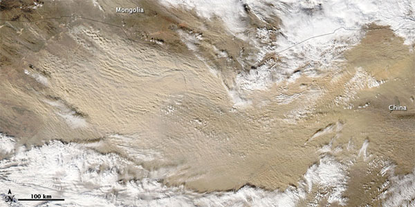
Out-of-Season Sandstorm Hits Gobi Desert

This image of a dust storm that blew through the Gobi Desert on Nov. 10, 2010, is evidence of how quickly the storm intensified as the day wore on. When NASA's Aqua satellite captured this image the dust plumes south of the Mongolia-China border were considerably thicker than they had been less than two hours earlier.
The Gobi has long ranked as one of the world's top dust-producing regions. A sand sea in north-central China provides plentiful material for dust storms this dust storm originated there.
The fifth largest desert in the world, the Gobi, which means 'waterless place' in Mongolian, is the most expansive arid region on the Asian continent, spanning two countries, China and Mongolia. The Gobi occupies a vast arc of land 1,000 miles (1,600 kilometers) long and 300 to 600 miles (500 to 1,000 km) wide, with an estimated total area of 500,000 square miles (1,300,000 square km).
The Gobi is a cold desert, and its annual temperature range is large. Average lows in January reach minus 40 degrees F (minus 40 degrees Celsius) and average highs in July reach 113 F (45 C).
The dust storm in this image forms an arc that curves to the southeast and northeast. The storm occupies an area of clear sky in between two cloudbanks, and the clouds could be related to the same weather system that stirred the dust. This storm is slightly out of character as most sandstorms in the Gobi occur in March and April.
The Harshest Environments on Earth Image Gallery: Earth as Art The World's Weirdest Weather
Get the world’s most fascinating discoveries delivered straight to your inbox.
 Live Science Plus


