It's quick and easy to access Live Science Plus, simply enter your email below. We'll send you a confirmation and sign you up for our daily newsletter, keeping you up to date with the latest science news.
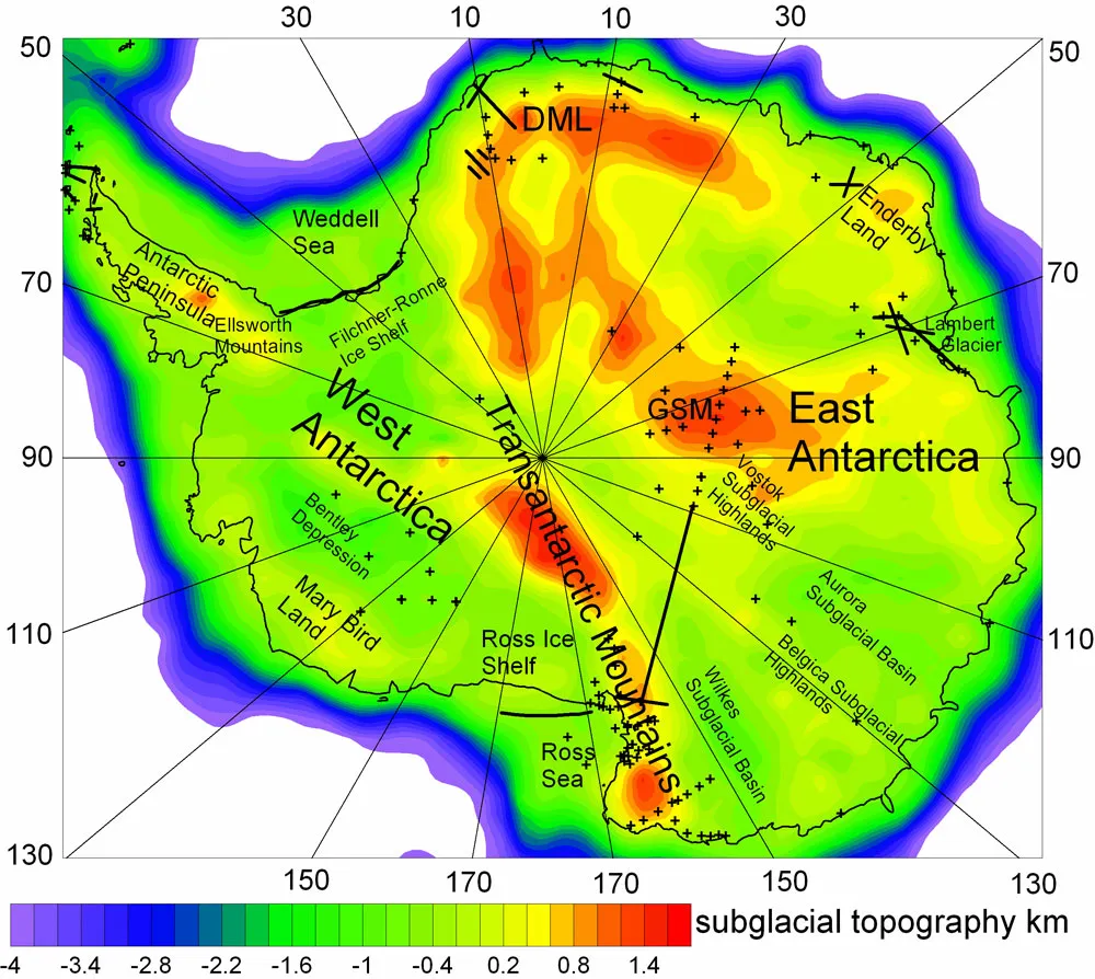
A map of Antarctica with the relief of the terrain below it's ice as indicated by seismic data. Abbreviations: DML, Dronning Maud Land; GSM, Gamburtsev Subglacial Mountains.
(Image credit: Baranov, A., Morelli, A., The Moho depth map of the Antarctica region, Tectonophysics (2013))
Much Antarctic research focuses on ice — and rightfully so, since a giant ice cap up to 2,361 miles (3,800 meters) thick covers about 99 percent of the continent. But under that layer of frozen water, Antarctica, like the planet's six other major landmasses, is made of continental crust.
Now, researchers analyzing seismic data from the southernmost continent have put together a new map showing the depth of Antarctica's crust. With a resolution of 1 degree by 1 degree, the map (detailed in a study published online Jan. 12 in the journal Tectonophysics) provides the most detailed look yet at variations in the thickness of Antarctica's crust.
"Antarctica represents the least-known continent, but the little we know points to significant geological peculiarities," said Alexey Baranov, a geophysicist with the Russian Academy of Sciences, who led the study. "Crustal structure is a key for understanding past geodynamical processes" and events that have shaped the Earth's surface, he told OurAmazingPlanet.
The team modeled Antarctica's crustal thickness by looking for a seismic boundary called the Moho, or the Mohorovičić discontinuity. The Moho represents the boundary between the Earth's crust and its mantle. Primary seismic waves (P-waves) change speeds sharply when they reach the Moho, so it's a relatively easy boundary for geophysicists to recognize.
Our Amazing Planet Top to Bottom. 18"x72" infographic poster. Buy Here
(Image credit: LiveScience Store)
Antarctica's oldest crust, which dates back to the Archean and Proterozoic eons, ranges from 22 to 35 miles (36 to 56 kilometers) deep, according to Baranov's analysis. The youngest continental crust, which is found in the West Antarctic Rift System, reaches depths of 10 to 17 miles (16 to 28 km). Across the entire continent, the Moho has an average depth of 21 miles (33.8 km).
The new crustal thickness model of Antarctica differs from previous estimates by up to 15 miles (24 km) — as much as 30 percent — because it includes a lot of data that wasn't incorporated in previous models, Baranov said.
Since many geophysical parameters, including the Earth's gravity field, are sensitive to variations in the thickness of the crust, Baranov's data will be important for other researchers studying the geodynamical processes that have shaped the continent.
Sign up for the Live Science daily newsletter now
Get the world’s most fascinating discoveries delivered straight to your inbox.
Several geologic features make Antarctica's crust particularly interesting, Baranov said.
The continent has several ancient cratons (stable chunks of continental crust preserved for billions of years) along with mountain belts and rifts (areas where the crust is being pulled apart) all almost completely covered by ice. The West Antarctic Rift System is the largest rifting zone in the world, and the Transantarctic Mountains are the planet's largest known range of noncollisional mountains, or mountains formed when a continental tectonic plate slides over an oceanic plate.