


Stormier Pattern Increasing White Christmas Odds
This article was provided by AccuWeather.com.
While some areas of the U.S. already have a high chance of a white Christmas* this year, an active winter storm track across the country is increasing the odds for others.
* - Since many people may have a different idea of what constitutes a white Christmas, it is being defined in this story as a snow depth of an inch or more on Christmas Day.

Mountains in West Have Highest Chance of White Christmas While a western storm train continues this week and into next week, the Cascades in Washington and Oregon, the Sierra in California and the Rockies are expected to have a white Christmas this year.
As much as 2-4 feet of snow has blanketed the mountains of the West over the past weekend, so there is a substantial snowcover.
Flagstaff, Ariz., has a decent chance of a white Christmas. There is currently a snow depth of more than a foot on the ground from heavy snow that fell over the weekend. While some of the snow will melt, there are a couple more snow opportunities leading up to Christmas Day.
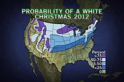
RELATED: Probability of a White Christmas Climate Origins of a White Christmas How To Forecast a White Christmas
Get the world’s most fascinating discoveries delivered straight to your inbox.
"Flagstaff could have around half of a foot of snow left on the ground by Christmas Day," AccuWeather Expert Senior Meteorologist Jim Andrews said.
While there is not much snow on the ground now in Salt Lake City, Utah, two chances of snow may be just enough to provide a true white Christmas. One round of snow will fall before midweek and a second round of snow may arrive on Christmas Eve.
"It's still open in Denver. There is no snow on the ground now. They have two shots at snow, including one the night before Christmas into Christmas Day," Andrews said.
Good Chance for a White Christmas Across Upper Midwest Meanwhile, a huge storm will bring wind-blown snow from the Rockies to the central Plains and the Upper Midwest during the middle of this week. Cities from Kansas City to Green Bay may receive substantial snow amounts from the storm.
Whether areas impacted by the storm have a white Christmas or not will depend on where cold air sticks around to keep snow on the ground.
The Upper Midwest, including the Upper Peninsula of Michigan, Wisconsin, and portions of lower Michigan may stay cold enough for a white Christmas. In fact, reinforcing cold air and lake-effect snow downwind of the Great Lakes through the weekend will increase the chances for many communities.
One to two feet of snow may blanket the typical snowbelts downwind of the Great Lakes.
The chance for a white Christmas may be lower for the central Plains, including portions of Nebraska, Kansas, Missouri and Iowa, where temperatures may warm up enough to melt snow.
Northern New England May Have White Christmas, Mid-Atlantic Not Likely Northern New England and areas to the lee of the Great Lakes have the best chance for a white Christmas in the East.
There will be a round of snow for northern New York and northern New England Tuesday into Wednesday.
More snow will arrive with a storm across northern New England late this week and into the weekend. This storm will drag much colder air into the Northeast, triggering lake-effect snow downwind of the Great Lakes.
It does not appear likely that New York City, Philadelphia and Washington, D.C., will have a white Christmas.
AccuWeather.com. All rights reserved. More from AccuWeather.com.
The weather is getting stranger, right? Well, for the most part no, scientists say, but humans often think so when a strange event does occur. So here’s your chance to prove how much you known about weather oddities.
Weird Weather: One Strange Quiz
