It's quick and easy to access Live Science Plus, simply enter your email below. We'll send you a confirmation and sign you up for our daily newsletter, keeping you up to date with the latest science news.
A helicopter battled near-hurricane-force winds as a team of seismologists fought its way through a treacherous mountain pass to reach the Alaska Peninsula's Katmai area. Their goal: to install a network of seismometers around the Katmai Volcanoes, the source of the largest volcanic eruption since Indonesia's Mount Tambora in 1815.
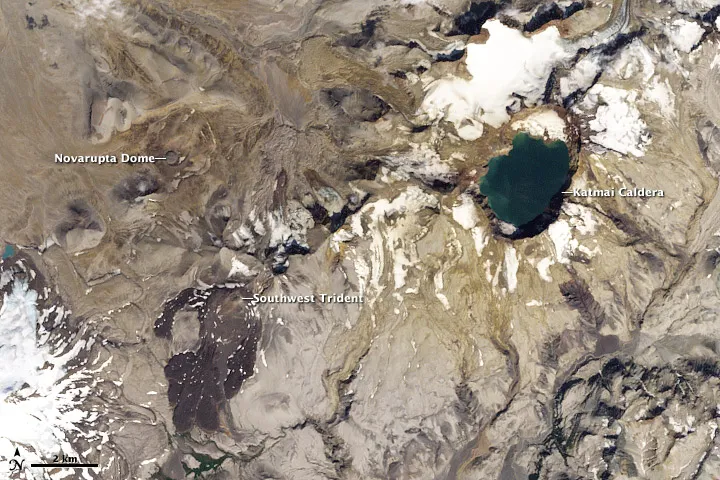
Four years and mounds of data later, the team is beginning to understand the plumbing system beneath that group of volcanoes, including the magma source for the 1912 Novarupta eruption, which spewed 3 cubic miles (12 cubic kilometers) of magma and dwarfed the 1980 Mount St. Helens eruption 30 times over.
"We're still trying to understand what's beneath, how the whole system behaved and why," said Clifford Thurber, a seismologist at the University of Wisconsin-Madison who led the study. "There will absolutely be future eruptions in the Katmai area, but they are unlikely to be these cataclysmic giant eruptions."
The Katmai Volcanoes are part of the subduction zone created by the Pacific plate plunging under the North American plate. Subduction zones are responsible for some of the Earth's most violent volcanoes and earthquakes.
The monstrous 1912 Novarupta eruption left few clues about its magma source. Mount Katmai, located about 6 miles (10 km) from Novarupta, collapsed during the eruption, leading researchers to assume the magma had been stored beneath it. [10 Biggest Volcanic Eruptions in History]
"That's one really confusing aspect about the whole thing, and it suggests there was some sort of connected volume of magma being stored underground," Thurber told OurAmazingPlanet. "Now the question is, where is it and how much is left?"
Sign up for the Live Science daily newsletter now
Get the world’s most fascinating discoveries delivered straight to your inbox.
His team turned to seismic waves to answer those questions.
Earthquake activity is related to volcanic eruptions because, as magma changes temperature and moves around, the Earth's surface responds, Thurber explained.
Lee Powell and John Paskievitch installing temporary seismic station at Mt. Mageik in the Katmai area of Alaska for a 2012 study on the volcanoes there.
(Image credit: USGS AVO photograph by Stephanie Prejean)
"There probably was a large volume of magma beneath the Katmai area, and as it sat there and cooled a bit, it lost its ability to hold volatiles and gave off gases," he said. "Basically the whole region was stressed by this pressure-cooker magmatic system, and those stresses could cause earthquakes."
Substantial, but not huge
Thurber's team used two techniques to model the region's magma plumbing: body wave tomography and ambient noise tomography.
The first is similar to a CAT scan, Thurber explained, but instead of X-rays, scientists use seismic waves to model cross-sections of the Earth. Ambient noise tomography, on the other hand, relies on extensive computer processing to tease out distinctive patterns in the background vibrations — from ocean waves, wind and even vehicles — that constantly rattle the Earth.
From those models, Thurber's team identified at least two remaining magma reservoirs.
One reservoir is located under Mount Katmai, the mountain that collapsed during the 1912 eruption. The second lies beneath Mount Mageik, 6 miles (10 km) southwest of Novarupta. The reservoirs are located at a depth of about 2 to 3 miles (3 to 5 km) and each is about 1 to 2.5 miles (2 to 4 km) wide, Thurber said. The team has not yet calculated their volumes.
"The magma beneath Katmai and Mageik is substantial, but the sort of huge zone of magma that would produce the 1912 eruption isn't down there," Thurber said.
The team's findings appear in the first twice-yearly issue of the 2012 volume of the journal Alaska Park Science.
This story was provided by OurAmazingPlanet, a sister site to LiveScience.

 Live Science Plus