It's quick and easy to access Live Science Plus, simply enter your email below. We'll send you a confirmation and sign you up for our daily newsletter, keeping you up to date with the latest science news.
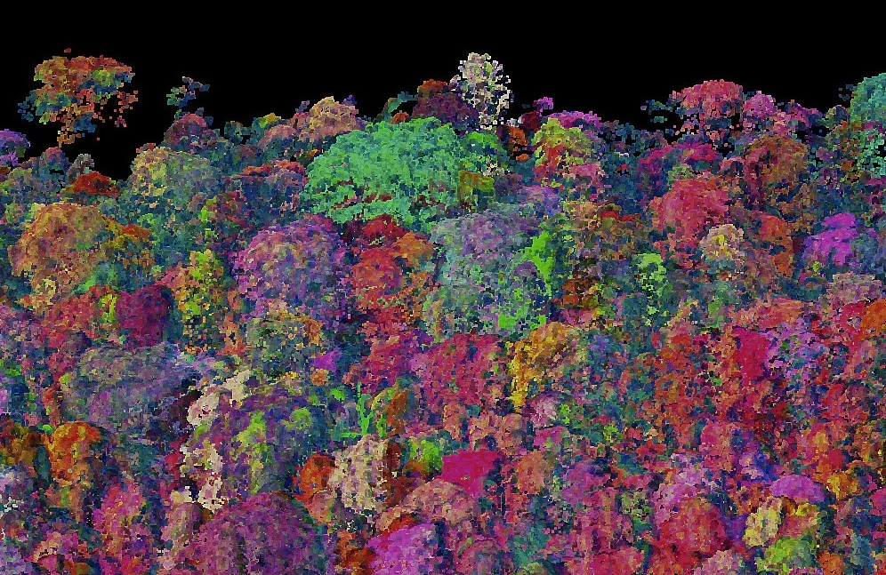
This three-dimensional chemical map of a forest in Panama uses colors to reveal the different chemical compositions of vegetation. Similar maps help researchers understand how diverse and healthy tropical forests are.
(Image credit: Carnegie Airborne Observatory, Carnegie Institution for Science)
A flying laboratory capable of assembling three-dimensional maps of dense, hard-to-explore tropical forests launches today (June 2) from a California airport.
The plane, Carnegie Airborne Observatory 2 (CAO 2), is a more powerful version of its predecessor, which began exploring remote tropical forests by air after its launch in late 2006. A major goal, said project researcher Gregory Asner, is to help local governments manage the forests and mitigate the effects of human habitation. For instance, Peruvian officials have used CAO 1 data to guide the restoration of the Amazon forest from damage caused by gold mining, said Asner, a tropical ecologist at the Carnegie Institution for Science at Stanford University.
"It sounds pie-in-the-sky, but in fact, we're seeing a lot of success," Asner told LiveScience.
The twin-engine plane, funded by private donations, is set to take off at about 3 p.m. Pacific time from a private airport in the San Francisco Bay area. After the test run, the plane is to be flown to Peru and Colombia for a summer mapping mission.
The plane is loaded with sensors that can detect the chemical composition of vegetation from the canopy to the forest floor. Capable of taking 60,000 measurements a second, the plane can cover 80,000 acres (32,375 hectares) on a good day, Asner said.
The new CAO is loaded with high-tech sensors, including one made by NASA's Jet Propulsion Laboratory.
Because different families of plants have different chemical makeups, the data collected enables the researchers to map out individual trees in candy-colored hues, a representation of the diversity of species found in the forests. [See images of the rainbow-colored forests]
"How diverse is the forest? Does it have just a few species or hundreds? The chemistry provides that window into mapping out the diversity of the forest itself," Asner said.
Sign up for the Live Science daily newsletter now
Get the world’s most fascinating discoveries delivered straight to your inbox.
The chemical data also can help scientists diagnose the health of the forests, revealing how plants are coping with environmental stress such as drought, temperature changes and human encroachment.
Beyond understanding the effect of human activities on tropical forests (and helping humans protect them), there's an aspect of pure exploration to the airborne observation project, Asner said.
"There are still large, large regions of the world that we know little about, and tropical rain forests always rise to the top of that list," he said. "The airborne observatory gives us the unique capability to explore."
You can follow LiveSciencesenior writer Stephanie Pappas on Twitter @sipappas. Follow LiveScience for the latest in science news and discoveries on Twitter @livescienceand on Facebook.
Stephanie Pappas is a contributing writer for Live Science, covering topics ranging from geoscience to archaeology to the human brain and behavior. She was previously a senior writer for Live Science but is now a freelancer based in Denver, Colorado, and regularly contributes to Scientific American and The Monitor, the monthly magazine of the American Psychological Association. Stephanie received a bachelor's degree in psychology from the University of South Carolina and a graduate certificate in science communication from the University of California, Santa Cruz.

 Live Science Plus