If you live anywhere within the northern two-thirds of the United States, you've probably noticed that it's pretty chilly outside. The plunge in temperatures over the past few days comes courtesy of an invasion of Arctic air that has been captured in a mesmerizing new animation from the National Oceanic and Atmospheric Administration.
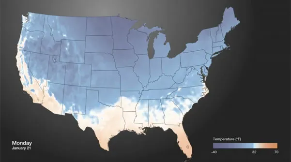
The animation, made with weather data from the NOAA/NCEP Real-Time Mesoscale Analysis, begins on Saturday (Jan. 19) with very cold air seen only over the Rockies, Montana, North Dakota, the northern half of Minnesota and the northern portions of New England. Much of the eastern and central parts of the country saw weekend weather that was balmier than usual for mid-January.
Thanks to a kink in the jet stream that brought it dipping down, the cold air begins plunging southward on Sunday, mostly in the northern plains states and the Midwest. On Monday it begins to surge even farther to the south, covering the Plains, the Midwest, the Northeast and even extending into some of the southern states.
Latest Videos From
The cold surge retreats a bit later in the day, then makes another push on Tuesday, fully extending into the northern parts of Mississippi, Alabama and Georgia. The pattern repeats on Wednesday, with the cold receding much farther north later in the day, before making another southward push on Thursday.
All the back-and-forth is caused by diurnal cycle of heating and cooling, a NOAA statement explains, but "the pattern is clear: much of the U.S. is pretty cold," it notes.
The cold air is expected to retreat from the Midwest this weekend, letting warmer air force its way in, according to Accuweather.com. The collision of these air masses will bring an ice storm to the region, the site's meteorologists predict.
Snow and icy weather could hit the eastern United States starting tomorrow (Jan. 25), with temperatures finally rising above freezing over the weekend or early next week, depending on the location.
This story was provided by OurAmazingPlanet, a sister site to LiveScience. Reach Andrea Thompson at athompson@techmedianetwork.com and follow her on twitter @AndreaTOAP. Follow OurAmazingPlanet on Twitter @OAPlanet. We're also on Facebook and Google+.

 Live Science Plus