
 Live Science Plus


Planetary Palette: Artistic Views of Mars


Dust Storm

Opportunity Rover Pancam Panorama

This full-circle scene combines 817 images taken by the panoramic camera (Pancam) on NASA's Mars Exploration Rover Opportunity.
Martian Crater

This large crater, which measures 15 miles (25 kilometers) across, has excavated rocks which have been altered by groundwater in the crust before the impact occurred. Using ESA's Mars Express and NASA's Mars Reconnaissance Orbiter, scientists have identified hydrated minerals in the central mound of the crater, on the crater walls and on the large ejecta blanket around the crater.

Curiosity Landing Target

This image shows changes in the target landing area for Curiosity, the rover of NASA's Mars Science Laboratory project. The larger ellipse was the target area prior to early June 2012, when the project revised it to the smaller ellipse centered nearer to the foot of Mount Sharp, inside Gale Crater. Image released June 11, 2012.
Gale Crater

Gale Crater: Target for Curiosity Mars rover.
New View of an Alien World

It's hard not to personify NASA's Mars rovers. Here, the rover Opportunity seems to peer out bravely into the great unknown Martian landscape.
Opportunity used its panoramic camera to capture this view of Endeavour Crater on March 9, 2012 during the late afternoon (Mars time, of course). The rover has been exploring the western rim of Endeavour Crater since August 2011. The crater spans 14 miles (22 km) in diameter, about the size of Seattle.
Mars Sand Dunes
Dusty, glass-rich sand dunes like these found just south of the north polar ice cap could cover much of Mars. (False color image)
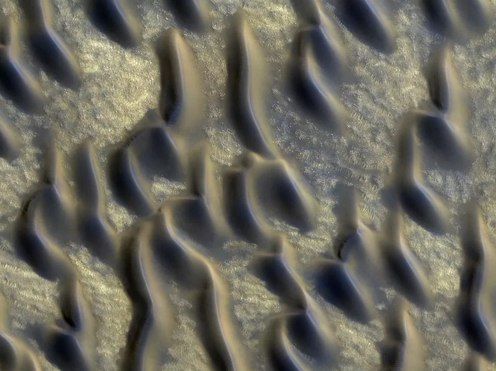
Martian Art

The alienlike beauty of this image, taken by a camera aboard NASA's Mars Reconnaissance Orbiter (MRO), may seem to portend some Martian artists. Alas, the ridges and ripples are evidence of Martian sand dunes. The brighter features represent two classes of so-called aeolian bedforms within Proctor Crater. The ripples, research has shown, are composed of fine sand or fine sand coated with coarser sand and granules. And the larger, darker bedforms are dunes composed of sand, possibly derived from basaltic, or volcanic, rock (and hence the darker color). Ripples tend to move slower than dunes. Because of this, over time, ripples get covered with dust, possibly explaining the bright tone visible here. The image was taken by the MRO's High Resolution Imaging Science Experiment (HiRISE) on Feb. 9, 2009.
Springtime on Mars

Early spring in the northern hemisphere of Mars, as shown in this Sept. 30, 2011 photo taken by the High Resolution Imaging Science Experiment (HiRISE) camera. These dunes are covered with a layer of seasonal carbon dioxide ice (dry ice), with bluish cracks in the ice visible across the top of some of the dunes.
Dark fan-shaped deposits around the edges of the dunes form where the ice has sublimated (changed from ice to gas) and the ice layer has ruptured, allowing the sand from the dune to escape out from under the ice. The sand is then free to be blown by the wind.
Alien Dust Devil!

NASA's HiRISE camera makes it possible to see the weather worlds and worlds away. Any guesses which planet this dust devil is sweeping across?
The rusty soil probably gave it away: It's Mars. The High Resolution Imaging Science Experiment (HiRISE) is a camera aboard the Mars Reconnaissance Orbiter,which sends back ultra-high-resolution images of the surface of Mars. HiRISE caught this alien twister scouring the dusty Martian surface in the late Martian spring. Researchers calculate that the dust plume reached 2,625 feet (800 meters) high. Martian winds blew the plume out toward the east as the dust devil itself headed southeast.
A Planetary Valentine

Mars may have been the god of war, but his namesake planet is all about love — at least topographically.
In 1999, the Mars Global Surveyor snapped this photograph of a "Valentine" from the Red Planet. The "heart" is actually a pit formed by a collapse within a graben, which is a geological term for a straight-walled trough which forms along fault lines. The heart-shaped pit is 1.4 miles (2.3 kilometers) across at its widest point, and sits on the slopes of the Alba Patera volcano.
