 Live Science Plus


3-D Images Reveal How Earth's Crust Forms
You are now subscribed
Your newsletter sign-up was successful
Want to add more newsletters?

Delivered Daily
Daily Newsletter
Sign up for the latest discoveries, groundbreaking research and fascinating breakthroughs that impact you and the wider world direct to your inbox.

Once a week
Life's Little Mysteries
Feed your curiosity with an exclusive mystery every week, solved with science and delivered direct to your inbox before it's seen anywhere else.

Once a week
How It Works
Sign up to our free science & technology newsletter for your weekly fix of fascinating articles, quick quizzes, amazing images, and more

Delivered daily
Space.com Newsletter
Breaking space news, the latest updates on rocket launches, skywatching events and more!

Once a month
Watch This Space
Sign up to our monthly entertainment newsletter to keep up with all our coverage of the latest sci-fi and space movies, tv shows, games and books.

Once a week
Night Sky This Week
Discover this week's must-see night sky events, moon phases, and stunning astrophotos. Sign up for our skywatching newsletter and explore the universe with us!
Join the club
Get full access to premium articles, exclusive features and a growing list of member rewards.
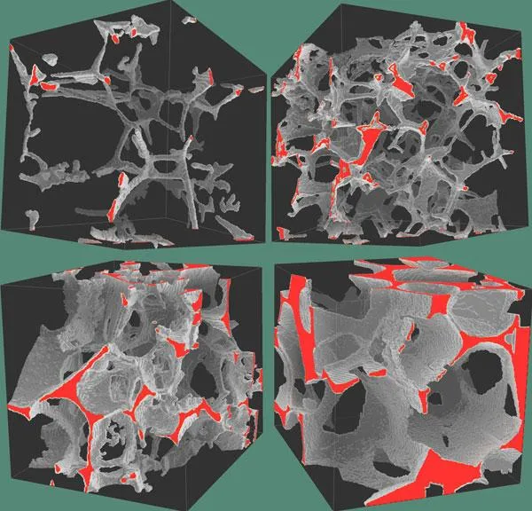
Details into how most of the crust that covers the planet formed are now emerging from new 3-D X-ray images of melted rock.
More than 60 percent of the Earth's surface formed at volcanoes on deep-sea ridges in the middle of oceans where tectonic plates are spreading apart. However, investigations of how magma seeps from these mid-ocean ridges where new crust is created have been limited to indirect seismic images of the ocean crust or two-dimensional images of melted rocks. The images either lacked fine detail as to what the rock was doing or potentially failed to capture the complexity of how it was structured in three dimensions.
In the lab, the scientists used rocks chemically similar to the so-called peridotites from the mantle layer beneath the crust. These were partially melted at temperatures of 2,460 degrees Fahrenheit (1,350 degrees Celsius) and high pressures of more than 217,000 pounds per square inch, to mimic the conditions below the seafloor crust, before they were returned to room temperature and pressures.
The investigators found these rocks formed porous networks on the scale of single mineral grains. Their findings suggest that interconnected networks of partially molten rock allow buoyant magma to rise up to the seafloor, leading new oceanic crust to form at mid-ocean ridges.
In the future, the researchers hope to image the rocks while they are heated and kept under pressure.
"If we can develop such a technique, then we will be able to visualize the formation process of mantle peridotites at mid-ocean ridges," researcher Wenlu Zhu, a geophysicist at the University of Maryland, College Park, told OurAmazingPlanet. "This one is dubbed 'four-dimensional' imaging — that is, three dimensions in space plus one dimension in time."
The scientists detailed their findings in the April 1 issue of the journal Science.

