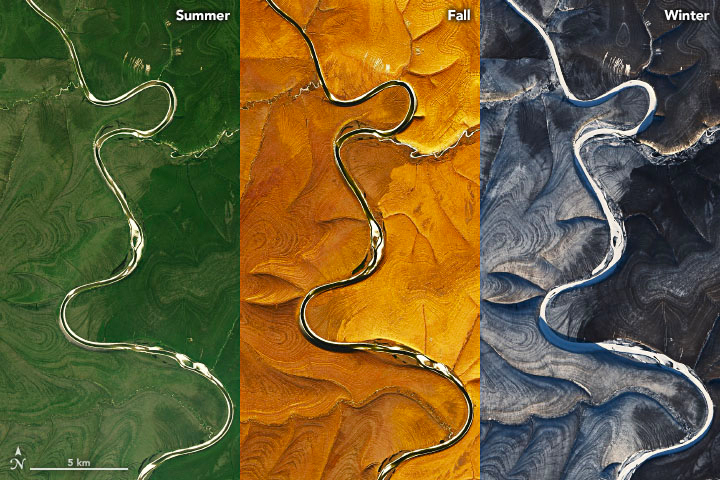
Mysterious stripes spotted over Russia in satellite images — and NASA is perplexed
Scientists can't agree on why these hills in the Russian Arctic ripple with stripes.

Get the world’s most fascinating discoveries delivered straight to your inbox.
You are now subscribed
Your newsletter sign-up was successful
Want to add more newsletters?

Delivered Daily
Daily Newsletter
Sign up for the latest discoveries, groundbreaking research and fascinating breakthroughs that impact you and the wider world direct to your inbox.

Once a week
Life's Little Mysteries
Feed your curiosity with an exclusive mystery every week, solved with science and delivered direct to your inbox before it's seen anywhere else.

Once a week
How It Works
Sign up to our free science & technology newsletter for your weekly fix of fascinating articles, quick quizzes, amazing images, and more

Delivered daily
Space.com Newsletter
Breaking space news, the latest updates on rocket launches, skywatching events and more!

Once a month
Watch This Space
Sign up to our monthly entertainment newsletter to keep up with all our coverage of the latest sci-fi and space movies, tv shows, games and books.

Once a week
Night Sky This Week
Discover this week's must-see night sky events, moon phases, and stunning astrophotos. Sign up for our skywatching newsletter and explore the universe with us!
Join the club
Get full access to premium articles, exclusive features and a growing list of member rewards.
Near the Markha River in Arctic Siberia, the earth ripples in ways that scientists don't fully understand.
Earlier this week, NASA researchers posted a series of satellite images of the peculiar wrinkled landscape to the agency's Earth Observatory website. Taken with the Landsat 8 satellite over several years, the photos show the land on both sides of the Markha River rippling with alternating dark and light stripes. The puzzling effect is visible in all four seasons, but it is most pronounced in winter, when white snow makes the contrasting pattern even more stark.
Why is this particular section of Siberia so stripy? Scientists aren't totally sure, and several experts offered NASA conflicting explanations.
Related: Earth's 8 biggest mysteries
One possible explanation is written in the icy ground. This region of the Central Siberian Plateau spends about 90% of the year covered in permafrost, according to NASA, though it occasionally thaws for brief intervals. Patches of land that continuously freeze, thaw and freeze again have been known to take on strange circular or stripy designs called patterned ground, scientists reported in a study published in January 2003 in the journal Science. The effect occurs when soils and stones naturally sort themselves during the freeze-thaw cycle.
However, other examples of patterned ground — such as the stone circles of Svalbard, Norway — tend to be much smaller in scale than the stripes seen in Siberia.
Another possible explanation is erosion. Thomas Crafford, a geologist with the U.S. Geological Survey, told NASA that the stripes resemble a pattern in sedimentary rocks known as layer cake geology.
Get the world’s most fascinating discoveries delivered straight to your inbox.
These patterns occur when snowmelt or rain trickles downhill, chipping and flushing pieces of sedimentary rock into piles. The process can reveal slabs of sediment that look like slices of a layer cake, Crafford said, with the darker stripes representing steeper areas and the lighter stripes signifying flatter areas.
In accordance with the image above, this sort of sedimentary layering would stand out more in winter, when white snow rests on the flatter areas, making them appear even lighter. The pattern fades as it approaches the river, where sediment gathers into more uniform piles along the banks after millions of years of erosion, Crafford added.
This explanation seems to fit well, according to NASA. But until the region can be studied up close, it'll remain another one of those quintessentially Siberian curiosities.
Originally published on Live Science.

Brandon is the space / physics editor at Live Science. With more than 20 years of editorial experience, his writing has appeared in The Washington Post, Reader's Digest, CBS.com, the Richard Dawkins Foundation website and other outlets. He holds a bachelor's degree in creative writing from the University of Arizona, with minors in journalism and media arts. His interests include black holes, asteroids and comets, and the search for extraterrestrial life.
 Live Science Plus


