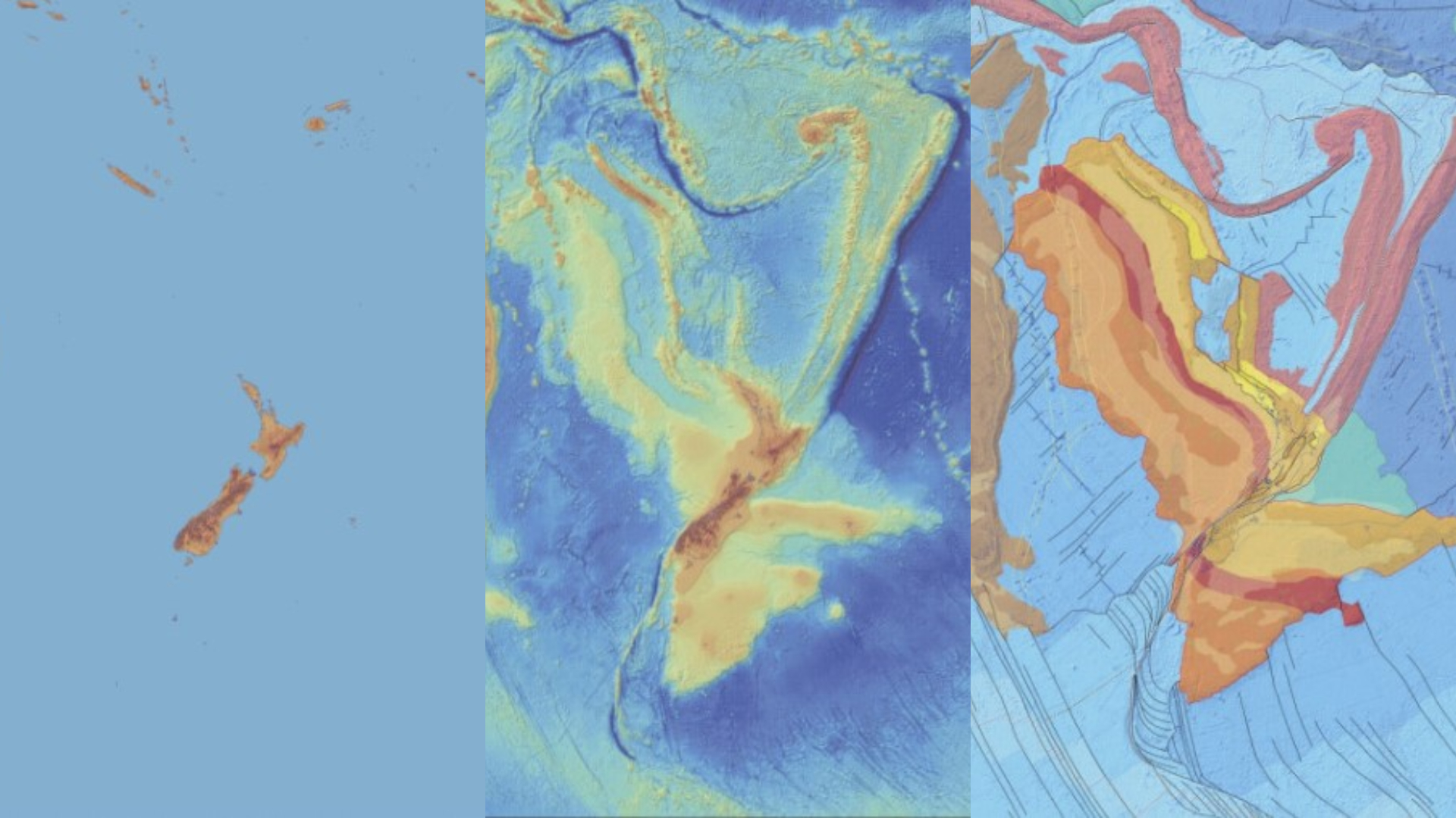
Zealandia, Earth's hidden continent, was torn from supercontinent Gondwana in flood of fire 100 million years ago
Scientists have fully mapped the lost continent of Zealandia in a world first, discovering new details about how it broke away from the supercontinent Gondwana through the ignition of a huge volcanic region tens of millions of years ago.
Get the world’s most fascinating discoveries delivered straight to your inbox.
You are now subscribed
Your newsletter sign-up was successful
Want to add more newsletters?

Delivered Daily
Daily Newsletter
Sign up for the latest discoveries, groundbreaking research and fascinating breakthroughs that impact you and the wider world direct to your inbox.

Once a week
Life's Little Mysteries
Feed your curiosity with an exclusive mystery every week, solved with science and delivered direct to your inbox before it's seen anywhere else.

Once a week
How It Works
Sign up to our free science & technology newsletter for your weekly fix of fascinating articles, quick quizzes, amazing images, and more

Delivered daily
Space.com Newsletter
Breaking space news, the latest updates on rocket launches, skywatching events and more!

Once a month
Watch This Space
Sign up to our monthly entertainment newsletter to keep up with all our coverage of the latest sci-fi and space movies, tv shows, games and books.

Once a week
Night Sky This Week
Discover this week's must-see night sky events, moon phases, and stunning astrophotos. Sign up for our skywatching newsletter and explore the universe with us!
Join the club
Get full access to premium articles, exclusive features and a growing list of member rewards.
The "lost continent" of Zealandia, which includes New Zealand and the French islands of New Caledonia, have been mapped out in full in a world first, providing scientists with a new understanding of how it formed tens of millions of years ago.
Zealandia, known as Te Riu-a-Māui in the Māori language, was first recognized as a continent in 2017 and is now the first to have its rock composition, volcanic activity and sedimentary features fully mapped out at its margins.
This is despite the continent being almost completely underwater, with only about 5% of Zealandia peeking above sea level. Researchers published their findings Sept. 12 in the journal Tectonics.
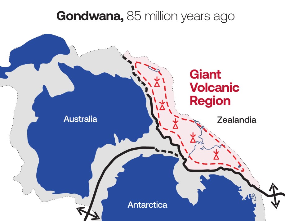
Overall, the area of Zealandia is estimated to be 1.9 million square miles (4.9 million square kilometers). In 2019, scientists mapped the geology of a region of south Zealandia spanning 0.6 million square miles (1.5 million square km). These findings revealed that Zealandia stretched, twisted and thinned as it broke off from the supercontinent Gondwana between 60 million and 100 million years ago.
Related: Is Africa splitting into two continents?
In the latest study, researchers mapped out the underwater region of north Zealandia, located between New Zealand, New Caledonia and Australia.
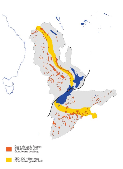
The scientists discovered that the separation of Zealandia from Gondwana was partly driven by a giant volcanic region containing magnetic lava rocks, which spanned the length of the boundary between the two land masses.
Get the world’s most fascinating discoveries delivered straight to your inbox.
"Molten magma flooded out of cracks and fissures as the continent stretched and thinned like pizza dough," Nick Mortimer, a geologist at the Institute of Geological and Nuclear Sciences Limited (GNS Science), said in a statement. This volcanic activity eventually helped to break Zealandia away from Gondwana.
"Until now, the role of magma in Gondwana breakup has been underestimated," Wanda Stratford, a marine geophysicist at GNS Science, said in the statement. These lavas cover an area of 100,000 square miles (250,000 square km) across the continent — which is about the size of New Zealand, she added.
By studying rock samples collected from the seabed near New Caledonia, the scientists were also able to fully map out a 100 million to 250 million-year-old backbone of granite that winds through the middle of the Zealandia.
The map of Zealandia could help to shed light on New Zealand’s resources, environment and natural hazards, GNS Science said in the statement.

Carissa Wong is a freelance reporter who holds a PhD in cancer immunology from Cardiff University, in collaboration with the University of Bristol. She was formerly a staff writer at New Scientist magazine covering health, environment, technology, nature and ancient life, and has also written for MailOnline.
 Live Science Plus


