A hidden continent birthed a new subduction zone near New Zealand

Get the world’s most fascinating discoveries delivered straight to your inbox.
You are now subscribed
Your newsletter sign-up was successful
Want to add more newsletters?

Delivered Daily
Daily Newsletter
Sign up for the latest discoveries, groundbreaking research and fascinating breakthroughs that impact you and the wider world direct to your inbox.

Once a week
Life's Little Mysteries
Feed your curiosity with an exclusive mystery every week, solved with science and delivered direct to your inbox before it's seen anywhere else.

Once a week
How It Works
Sign up to our free science & technology newsletter for your weekly fix of fascinating articles, quick quizzes, amazing images, and more

Delivered daily
Space.com Newsletter
Breaking space news, the latest updates on rocket launches, skywatching events and more!

Once a month
Watch This Space
Sign up to our monthly entertainment newsletter to keep up with all our coverage of the latest sci-fi and space movies, tv shows, games and books.

Once a week
Night Sky This Week
Discover this week's must-see night sky events, moon phases, and stunning astrophotos. Sign up for our skywatching newsletter and explore the universe with us!
Join the club
Get full access to premium articles, exclusive features and a growing list of member rewards.
South of New Zealand in the Tasman Sea is a stretch of stormy ocean where the waves regularly swell 20 feet (6 meters) or more and the winds blow at 30 mph (48 km/h) on a good day. Deep below these stormy seas, Earth is unquiet, too. This region is home to the Puysegur Trench, site of one of the youngest subduction zones on the planet. Here, the Australian plate is shoved under the Pacific plate, creating frequent large earthquakes, including a 7.2-magnitude quake in 2004.
Now, new research reveals how this baby subduction zone came to be: Over millions of years, a bit of the "hidden" continent of Zealandia on the boundary between the Australian and Pacific plates, got stretched and shifted in a way that led the denser oceanic crust to slam into — and under — it. This finding that positioning different types of crust against one another at a preexisting plate boundary leads to subduction may help to explain how other new subduction zones around the world form.
Related: Photo timeline: How Earth formed
"Subduction zones are one of the most important, if not the most important, plate boundaries," said study lead author Brandon Shuck, a doctoral candidate at The University of Texas at Austin. "They're really the main drivers of plate tectonics, so they're the primary reason why the plates on Earth actually move. And also they're very destructive plate boundaries. …We don't really understand well how they start out and how they form in the first place."
Research in the 'Furious Forties'
Subduction zone formation is mysterious because subduction zones are, by nature, destructive. When a plate of oceanic crust dives under continental crust, the rocks at the surface twist, break and deform. The oceanic slab, meanwhile, churns into the mantle, where it's melted beyond recognition. This leaves little geological history behind to study.
The subduction zone in the Puysegur margin is young enough that this history has not yet been erased. That makes it an ideal spot to answer the question of how subduction zones form in the first place, Shuck told Live Science. There's not yet any good explanation of how tectonic plates break open and start subducting.
Related: In photos: Ocean hidden beneath Earth's surface
Get the world’s most fascinating discoveries delivered straight to your inbox.
Studying the Puysegur margin is no easy feat, though, because it's in the "Roaring Forties," the latitudes between 40 degrees south and 50 degrees south where the winds and currents are brutal. Scientists aboard the research vessel Marcus Langseth set out to this region in 2018 as part of the South Island Subduction Initiation Experiment. It was a challenging trip, Shuck said. The crew had to spend almost a quarter of the time sheltering behind islands to avoid gales.
"Our boat was rolling side to side by like 20 degrees at one point," Shuck said. "It was a mess."
In spite of the weather, the researchers were able to deploy seafloor seismometers and to take seismic surveys of the subsurface, a method which uses reflected sound waves to see underground structures.
The making of a subduction zone
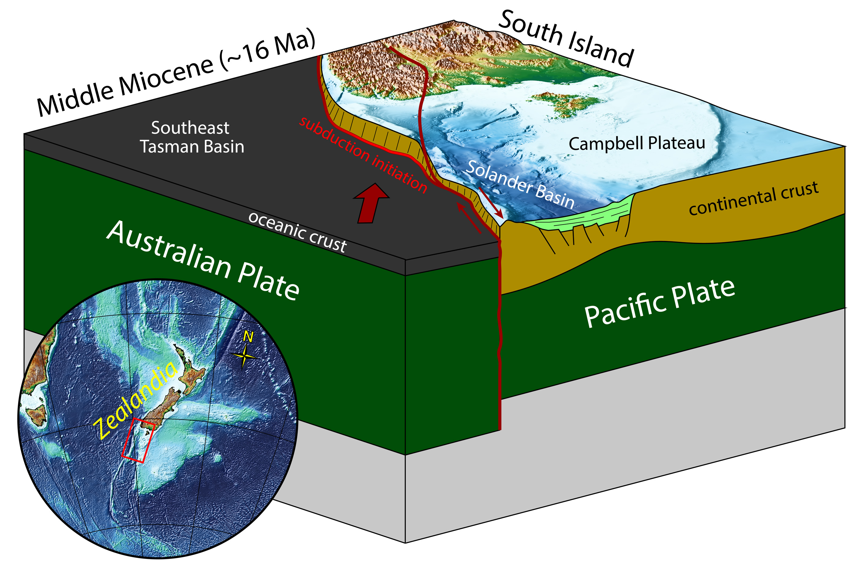
The new data allowed the researchers to put together a history of the young subduction zone, which Shuck presented at the virtual meeting of the Seismological Society of America on April 22, the same day the study was published in the journal Tectonics. It all started about 45 million years ago, when a new plate boundary between the Australian and Pacific plates began to form because of a force called extension -- basically, tectonic forces pulled the two plates apart like putty.
The oceanic crust at the plate boundary responded to this extension predictably: As the crust thin, magma from the mantle pushed up through fractures, hardening into new rock. This process is called seafloor spreading, and it's how new oceanic crust forms.
But there was a catch: The secret continent of Zealandia. Zealandia is a submerged section of continental crust the size of Australia around New Zealand. Zealandia was perched over the north end of this extensional zone. As continental crust is thicker and more buoyant, the extensional forces working at the plate boundary couldn't crack Zealandia. Instead, the continental crust merely stretched as it spread, creating a thinned-out zone now known as the Solander basin.
Now there were two plates. The Australian Plate, to the west, consisted of continental crust from Zealandia in the north and new oceanic crust in the south. The Pacific Plate, to the east, also consisted of oceanic crust in the south. To the north, the Pacific Plate hosted the thinned-out continental crust of the Solander basin. At the plate boundary, oceanic crust bumped up against oceanic crust, and continental crust against continental crust.
Likely little of interest would have happened, if not for another tectonic shift 25 million years ago.
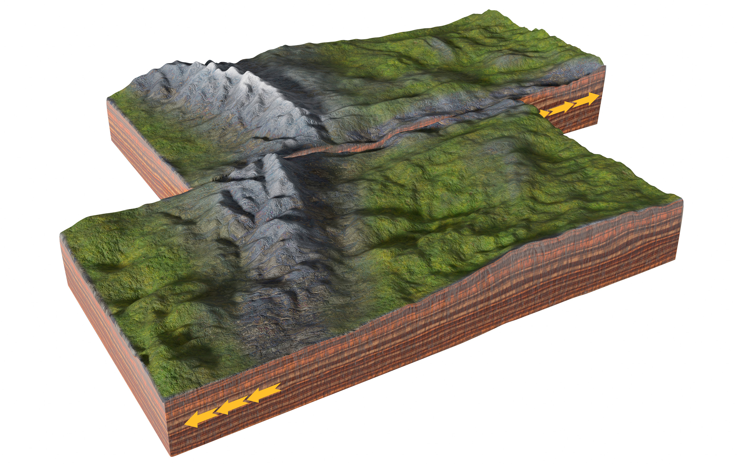
At that time, the Australian-Pacific plate boundary stopped pulling apart. Instead, the plates started to move past each other, creating what's known as a strike-slip fault. Now, the Pacific plate was moving south, and the Australian plate was moving north. This opposing movement brought the oceanic crust of the Australian plate right next door to the thin Solander basin continental crust on the Pacific plate.
This was the key to starting subduction, Shuck said: Continental crust is more buoyant than denser oceanic crust, and this difference in buoyancy allowed the denser part of the Australian plate to slide under the lighter Pacific one, especially because the boundary between these continental and oceanic plates was already weakened by the earlier strike-slip faulting. The findings drive home how important strike-slip movement is to tectonics, Shuck said.
"How plates rotate is really important," he said. "If you just think about pulling things apart and pushing them together you don't really create that much contrast, but [with] strike-slip, you're translating [sliding a portion of crust] and it's super-efficient. Just imagine, with the plates sliding past each other, you're going to cause materials of different properties to come together eventually."
Moving down the fault
There are other spots around the globe where strike-slip movement is happening in the same place as the compression and convergence of plates, particularly along the Queen Charlotte fault north of Vancouver and south of Alaska, Shuck said. That fault may be a place where a subduction zone could potentially form, he said.
Related: 10 amazing geological discoveries
But there are also many questions left to answer about the fault south of New Zealand. Speaking at the Seismological Society of America meeting on April 22, geophysicist Caroline Eakin of Australian National University described a research trip to Macquarie Ridge, an undersea ridge 620 miles (1,000 km) south of New Zealand on the same fault as the Puysegur margin. In October 2020, scientists deployed seafloor seismic instruments at this rugged ridge, which is only 28 miles (25 km) wide but rises 3.7 miles (6 km) from the surrounding topography.
The researchers will return to pick up the instruments and their data in November 2021, as long as the weather allows. If the Puysegur margin is in the "Roaring Forties," Macquarie Ridge is in the "Furious 50s." The research ship encountered 68 mph (109 km/h) winds while trying to deploy the instruments and spent 38% of the mission in such bad weather that scientists aboard couldn't do anything but shelter in place and wait. Nevertheless, they are hopeful that the new ocean-bottom seismometers (OBS) will open their eyes to what's going on beneath the ridge. Right now, the researchers know there are large quakes originating in the region, but they don't know much about how deep in the crust they are, what kind of faults they occur on or what kind of tsunami risks they pose to coastal areas in Australia.
"The OBS data will also allow us to image the subsurface beneath-the-plate boundary for the first time using different seismic imaging techniques," Eakin told Live Science. "Currently, most of our observations tell us about what is happening at the surface or near-surface, but we have no idea what is happening beneath the surface of the plate boundary in the Macquarie Ridge region."
One question they hope to answer: Will the fault at Macquarie Ridge begin to turn into a subduction zone, too? The Puysegur margin and Macquarie Ridge are related and are experiencing similar changes in plate motion over time, Eakin said, though Puysegur is further along in the process. Macquarie Ridge, being two slabs of oceanic crust coming together, might be more resistant to subduction than the continental crust and oceanic crust boundary at Puysegur, Shuck said; but subduction zones can also spread along a fault from a single point.
"Those two segments could actually link up — maybe — in the future," Shuck said.
Originally published on Live Science.

Stephanie Pappas is a contributing writer for Live Science, covering topics ranging from geoscience to archaeology to the human brain and behavior. She was previously a senior writer for Live Science but is now a freelancer based in Denver, Colorado, and regularly contributes to Scientific American and The Monitor, the monthly magazine of the American Psychological Association. Stephanie received a bachelor's degree in psychology from the University of South Carolina and a graduate certificate in science communication from the University of California, Santa Cruz.
 Live Science Plus


