


Hurricane Ian to unleash 'life-threatening' flooding in Florida as Category 4 storm
The storm is nearly Category 5 strength.
Editor's note: This is a developing story and may be updated.
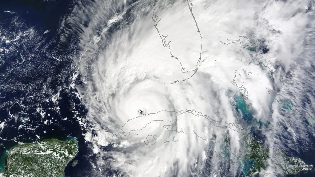
Hurricane Ian strengthened to a Category 4 storm early Wednesday (Sept. 28) morning having just passed over western Cuba, causing an island-wide blackout and killing at least two people. The storm's center is due to reach Florida's western shore within hours, the National Hurricane Center (NHC) warned at 11 a.m. ET on Wednesday.
Ian made landfall in Cuba on Tuesday (Sept. 27) as a Category 3 hurricane with maximum sustained winds around 125 mph (205 km/h). The cyclone was expected to dump some 6 to 10 inches (15.2 to 25.4 cm) of rain on the western half of the island, with some areas getting up to 16 inches (40.6 cm) of rainfall. State media reported two deaths in the western province of Pinar del Río, which endured heavy flooding and widespread destruction as the storm came ashore, CNN reported.
Cuba's entire power grid collapsed in the wake of the hurricane, and the western section of the three-part grid suffered the most damage, The New York Times reported. Some electricity had been restored on the eastern half of the island by Wednesday morning, but overall, it was unclear how much of the island still remained without power at that time.
As the storm swept into the southeastern Gulf of Mexico, it strengthened into a Category 4 storm with maximum sustained winds near 140 mph (220 km/h), the NHC reported at 5 a.m. ET. Two hours later, the storm intensified and began producing maximum sustained winds around 155 mph (250 km/h) — nearly reaching the Category 5 threshold of 157 mph (252 km/h).
Related: Hurricane season 2022: How long it lasts and what to expect
"Maximum sustained winds remain near 155 mph (250 km/h) with higher gusts," the NHC reported at 11 a.m. ET. "Ian is forecast to make landfall on the west coast of Florida as a catastrophic hurricane."
Get the world’s most fascinating discoveries delivered straight to your inbox.
"Catastrophic storm surge inundation of 12 to 18 feet [3.6 to 5.5 meters] above ground level along with destructive waves are expected somewhere along the southwest Florida coastline from Englewood to Bonita Beach, including Charlotte Harbor," the NHC warned at 11 a.m. ET. "Catastrophic wind damage is beginning along the southwestern coast of Florida today near the landfall location. Hurricane-force winds are expected to extend well inland along [sic] near the core of Ian."
RELATED STORIES
Heavy rainfall is expected across the entire Florida peninsula through Thursday (Sept. 29). "Considerable" flooding is expected in southern and northern regions of the state, and portions of central Florida are forecasted to endure "widespread, life-threatening catastrophic" flooding, due in part to anticipated river flooding in the region, the NHC stated.
Originally published on Live Science.

Nicoletta Lanese is the health channel editor at Live Science and was previously a news editor and staff writer at the site. She is a recipient of the 2026 AHCJ International Health Study Fellowship, with a project focused on antibiotic stewardship practices in Japan and the U.S. They hold a graduate certificate in science communication from UC Santa Cruz and degrees in neuroscience and dance from the University of Florida. Beyond Live Science, Lanese's work has appeared in The Scientist, Science News, the Mercury News, Mongabay and Stanford Medicine Magazine, among other outlets. Based in NYC, she also remains involved in dance and performs in local choreographers' work.