About 17,000 years ago, one of the largest megafloods in Earth's history inundated a large area of Alaska, releasing millions of gallons of water every second and forever changing the area's landscape.
One of at least four megafloods from ancient Glacial Lake Atna, the deluge breached ice dams and covered more than 3,500 square miles (9,065 square kilometers) of land of what is today the Copper River Basin northeast of Anchorage. (The lake would've covered Rhode Island three times.)
Megafloods by definition have a flow of at least 264 million gallons of water per second (1,000 million liters of water per second). The largest known freshwater megaflood released about 4,500 million gallons of water per second (17,000 million liters of water per second) and originated out of Glacial Lake Missoula in Montana.
Latest Videos From
The megaflood from Atna likely had a flow of about 792 million gallons of water per second (3,000 million liters of water per second), and released a total of as much as 336 cubic miles (1,400 cubic kilometers) of water – enough to cover an area the size of Washington, D.C., to a depth of 5 miles (8 km).
The signs of the Atna megaflood, detailed in May issue of the journal Quaternary Research, were found by Michael Wiedmer, an Anchorage native and graduate student at the University of Washington in Seattle, who formerly worked for the Alaska Department of Fish and Game.
In 2005, Wiedmer discovered pygmy whitefish living in Lake George, a glacial lake 50 miles (80 km) from Anchorage that was virtually emptied many times during its history and was not thought to support much life.
Wiedmer examined the fish and found they had physical traits that suggested they were closely related to pygmy whitefish living in three other mountain lakes, all remnants of Lake Atna. The existence of the pygmy whitefish in Lake George is one piece of evidence for the megaflood of Atna.
"Lake Atna linked up with four distinct drainages, and we think that helped it act like a pump for freshwater organisms," Wiedmer said.
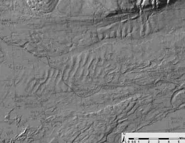
Different geological formations also present evidence of the flood, including huge dunes formed by the lake drainage that appear on topographical maps but are now covered by roads, buildings and other development. The dunes reached 110 feet (34 meters) high with a half-mile between crests.
"We believe the very large dunes were formed during the peak of the flood and then modified as the flood waned," Wiedmer told LiveScience in an e-mail.
Wiedmer's research also turned up evidence for another suspected megaflood from Atna along a different course that could have had a flow of 2,904 million gallons per second (11,000 million liters of water per second), as well as for two smaller megafloods.