Hawaii's Majestic Mauna Kea Stars in '3D' Photo from Space

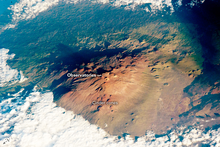
Mauna Kea, Hawaii's tallest volcano, is circled by clouds in a photo taken by an International Space Station astronaut. The setting sun cast dark shadows along the volcano’s eastern flank, lending a depth to the image which is unusual in satellite views of Earth.
A tiny ring of white specks at the volcano's summit represents the Mauna Kea astronomical observatory, the largest observatory in the world. Teams of astronomers from 11 countries operate 13 telescopes on Mauna Kea, studying the universe in a range of wavelengths that include optical, infrared, submillimeter and radio.
Mauna Kea's eyes on the skies include the Keck Observatory, Earth's largest optical/infrared telescopes, which took their first images of space — the spiral galaxy NG1232 — from Mauna Kea 25 years ago on Nov. 24, 1990. [Explosive Images: Hawaii's Kilauea Erupts for 30 Years]
Also dotting Mauna Kea's steep slopes are numerous cinder cones, some measuring hundreds of meters high, formed by fountaining lava.
Mauna Kea, which means "White Mountain" in Hawaiian, is estimated to be about 1 million years old. It towers 13,796 feet (4,205 meters) above sea level on the island of Hawaii, covering 23 percent of the island's surface. The dry, cloud-free conditions at the summit and the distance from urban light pollution afford unparalleled opportunities for unobstructed telescope observations.
The volcano is so tall that snow accumulates on its summit during winter months, sometimes to depths of nearly 10 feet (3 meters). Mauna Kea last erupted 4,500 years ago, but though the volcano is currently dormant, the possibility of future eruptions persists.
Meanwhile, one of the world's most active volcanoes, Mount Kilauea, lies on the southeastern side of the Big Island, rising some 4,190 feet (1,227 m) above sea level and covering about 14 percent of the island.
Get the world’s most fascinating discoveries delivered straight to your inbox.
The Mauna Kea image was captured at 5 p.m. local time on Nov. 1 and published online today (Nov. 30) by NASA's Earth Observatory.
Follow Mindy Weisberger on Twitter and Google+. Follow us @livescience, Facebook & Google+. Original article on Live Science.

Mindy Weisberger is a science journalist and author of "Rise of the Zombie Bugs: The Surprising Science of Parasitic Mind-Control" (Hopkins Press). She formerly edited for Scholastic and was a channel editor and senior writer for Live Science. She has reported on general science, covering climate change, paleontology, biology and space. Mindy studied film at Columbia University; prior to LS, she produced, wrote and directed media for the American Museum of Natural History in NYC. Her videos about dinosaurs, astrophysics, biodiversity and evolution appear in museums and science centers worldwide, earning awards such as the CINE Golden Eagle and the Communicator Award of Excellence. Her writing has also appeared in Scientific American, The Washington Post, How It Works Magazine and CNN.
 Live Science Plus


