 Live Science Plus


Yosemite National Park

Colorado National Monument

Fossilized tracks left by ancient dinosaur, lizard and turtles litter the Colorado National Monument. Hikers will also see natural potholes, or sandstone basins filled with rainwater, sediment, plants and animals, according to NASA.
Hot Springs National Park

Arkansas' national park has an urban center in its middle, but it still sports 8.7 square miles (22.5 square kilometers) of wilderness, including part of the Ouachita Mountains. The park is famous for the 700,000 gallons (2.6 million liters) of hot water that bubble up near Hot Springs Mountain every day. NASA's Landsat 8 snapped this photo in June 2013.
Article continues belowRedwood National Park

Grey rock, green vegetation, eye-catching redwoods and a wispy white beach can be seen in this image taken by the Enhanced Thematic Mapper Plus instrument on NASA's Landsat 7 satellite in 2003. Redwood National Park is one of the most seismically active in the U.S., leading to landslides and erosion along the coast, NASA said.
White Sands National Monument

When bodies of water evaporate, gypsum is left behind. It is gypsum that forms the white sands of this monument in America's Southwest, now in the form of tiny grains after having been broken down from its crystal form by various weather events. The Advanced Land Imager on NASA's Earth Observing-1 satellite took this image in 2009, the agency said.
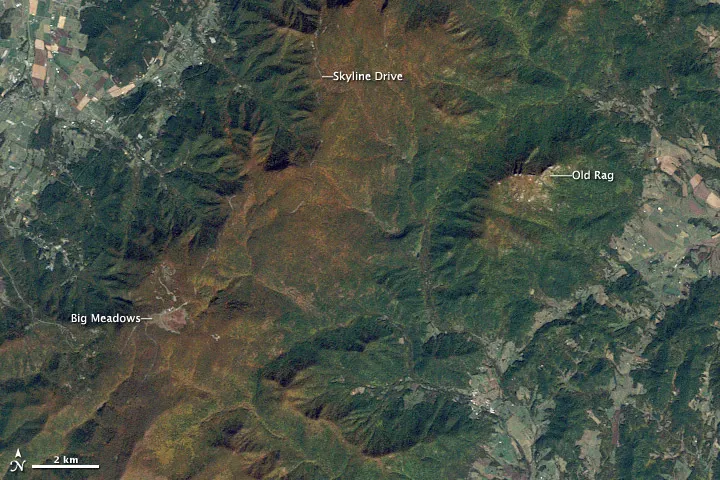
Shenandoah National Park

The reddish patches in this satellite photo are autumn foliage turning color, as captured by the Thematic Mapper NASA's Landsat satellite on Oct. 10, 2010. President Franklin Delano Roosevelt dedicated this national park in Virginia in 1936, and today hikers still enjoy the 280-square-mile (725 square kilometers) park in the Blue Ridge Mountains. Old Rag Mountain draws outdoor enthusiasts, but its rock scrambles make it a challenge for many to climb.
Grant Staircase-Escalante National Monument

Some of the land in this park once sat on the Earth's equator during the Permian Period, but tectonic forces moved it to its current location in south-central Utah. Researchers found two new herbivorous dinosaur species in this park in 2010. The Advanced Land Imager on NASA's Earth Observing-1 satellite snapped this image over the Kaiparowits Basin in 2005.
Joshua Tree National Park

It's hard to see the diversity of Joshua Tree from space, but the park is home to 700 plant species. Cacti, wildflowers, 25 types of snakes, various mammals including bighorn sheep and coyotes, hundreds of migratory birds and thousands of insect and arthropod species, such as tarantulas and scorpions, all live in the region. These diverse plant and animal species make use of the Mojave Desert and Colorado deserts, the Little San Bernardino Mountains and five desert palm oases. However, the park may be most famous for its Joshua trees, which hold precious water in times of drought.
Hells Canyon National Recreation Area

The Snake River in the Pacific Northwest carved out Hells Canyon about 6 million years ago. The enormous flood from Glacial Lake Bonneville in Utah shaped the area further about 15,000 years ago. Today, Hells Canyon is 8,043 feet (2,451 meters) above river level, which makes it deeper than the Grand Canyon.
Big Bend National Park

Once covered by the Cretaceous Sea about 135 million years ago, Big Bend National Park is now home to fossils of oysters, giant clams, turtles, rhinos and a nearly 50-foot-long (15 meters) crocodile, NASA reports. This large flying creature, with a wingspan the size of a small airplane, also lived in the region about 220 million to 65 million years ago. NASA's Landsat 7 satellite snapped this image of the park in southwestern Texas in 2002.

