Chile's Retreating San Quintín Glacier Viewed from Space (Photo)

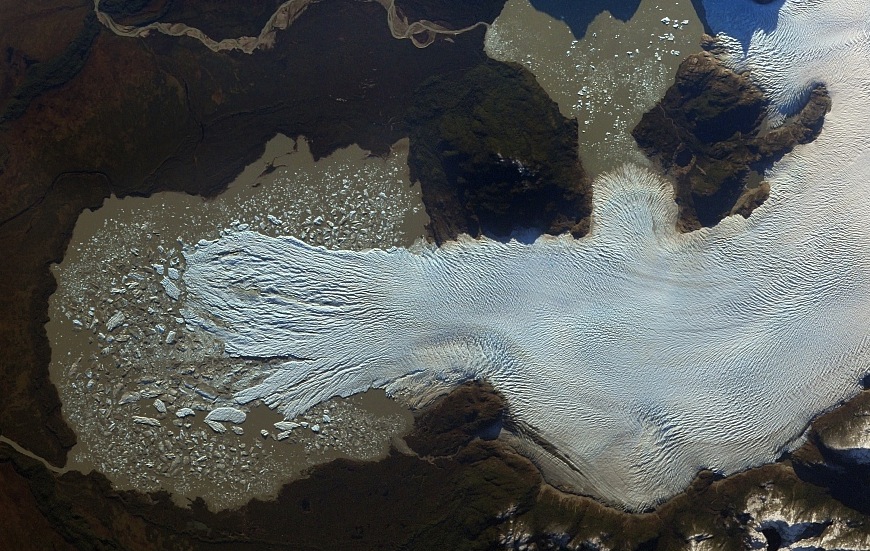
Fragmenting into glasslike shards in a lake full of glacier-churned "rock flour," Chile's San Quintín glacier can be seen emptying the Northern Patagonian Ice Field in a recent satellite photo.
The ice field, situated in the Andes Mountains of southern Chile, is in Laguna San Rafael National Park. Along with the Southern Patagonian Ice Field in Chile and Argentina, this is all that is left of the great Patagonian Ice Sheet, which covered the entire region during the last glacial period between 110,000 and 12,000 years ago.
San Quintín is one of 28 glaciers that drain the field. The glacier flows west, terminating in a lake made taupe by rocks ground into a fine dust by the movement of the ice, according to NASA's Earth Observatory. This dust is known as glacial flour. An outlet stream leads to the Pacific Ocean. Like many glaciers in the Andes, the San Quintín glacier has been retreating quickly in recent years. According to a 2013 study published in the journal The Cryosphere, more ice has been lost from Andes glaciers in the last 30 years than in the previous 400 years combined. [Images of Melt: Earth's Vanishing Ice]
On average, the study found, Andes glaciers lost between 30 and 50 percent of their surface area since the late 1970s. Some, like the Chacaltaya glacier of Bolivia, have completely vanished. Glacial streams provide drinking and agricultural water for communities below, so the ice loss is a major concern for the region.
This image of San Quintín was taken by the ISERV Pathfinder instrument aboard the International Space Station. ISERV is a camera that takes snapshots of at-risk areas in Central America, East Africa and the Himalayas, with the goal of helping government officials make decisions about climate change and natural hazards.
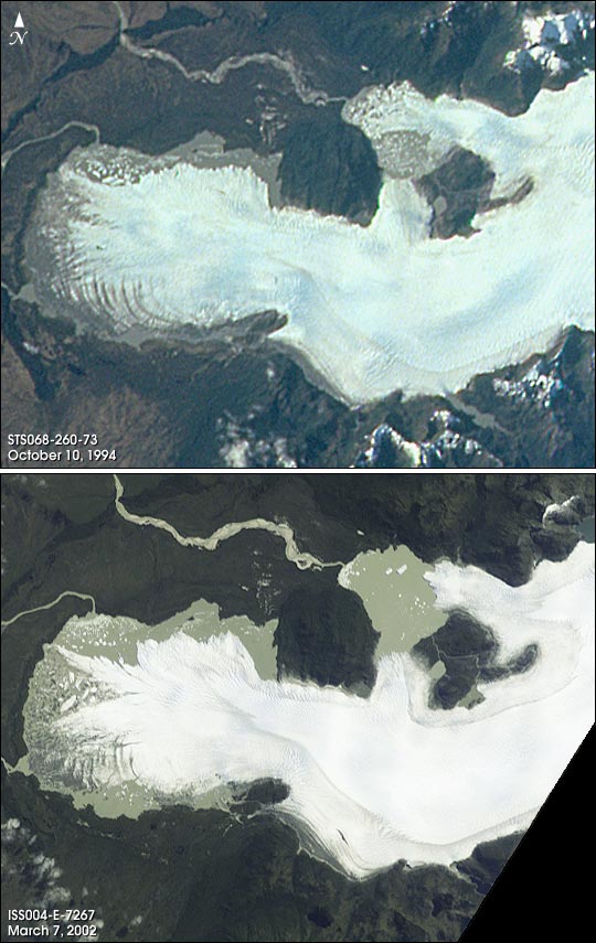
This image was taken on Saturday (June 2), part of a mosaic of eight shots of the glacier. NASA previously snapped photos of the San Quintín glacier in 2002 and 1994; each shows an inexorable loss of ice.
Editor's Note: If you have an amazing nature or general science photo you'd like to share for a possible story or image gallery, please contact managing editor Jeanna Bryner at LSphotos@livescience.com.
Get the world’s most fascinating discoveries delivered straight to your inbox.
Follow Stephanie Pappas on Twitter and Google+. Follow us @livescience, Facebook & Google+. Original article on Live Science.

Stephanie Pappas is a contributing writer for Live Science, covering topics ranging from geoscience to archaeology to the human brain and behavior. She was previously a senior writer for Live Science but is now a freelancer based in Denver, Colorado, and regularly contributes to Scientific American and The Monitor, the monthly magazine of the American Psychological Association. Stephanie received a bachelor's degree in psychology from the University of South Carolina and a graduate certificate in science communication from the University of California, Santa Cruz.
 Live Science Plus


