It's quick and easy to access Live Science Plus, simply enter your email below. We'll send you a confirmation and sign you up for our daily newsletter, keeping you up to date with the latest science news.
An image taken on June 7, 2014, by Landsat 8 shows a landslide that rushed through a remote part of western Colorado, partially covering up a natural gas well.
The menacing trail of a landslide that killed three people in western Colorado last month can be seen from space.
A new satellite image of the slide's scar, taken on June 7 by the planet-watching spacecraft Landsat 8, was released today (June 20) by NASA's Earth Observatory.
The May 25 disaster sent a wall of mud, as deep as 250 feet (76 meters), barreling down a mountainside near the town of Collbran in Colorado's Grand Mesa area, a region prone to landslides. The slide shook the surrounding area, and was even recorded by seismographic sensors; it registered as a small, 2.8-magnitude earthquake, according to the U.S. Geological Survey.
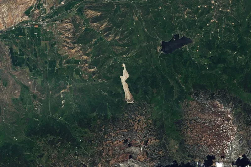
This Landsat 8 image from June 20, 2013, shows the region before the landslide.
(Image credit: NASA)
The disaster killed three men and left a trail of destruction more than 3 miles (4.8 kilometers) long and a half-mile (0.8 km) wide, The Denver Post reported.
For comparison, the Earth Observatory also released a Landsat 8 image snapped about a year earlier showing the previously unbroken green hillside.
Landsat 8, which launched into space in February 2013, is the newest satellite in the prolific Landsat program, a joint effort by NASA and the U.S. Geological Survey that started in 1972 to monitor the changing face of Earth.
The satellites' watchful gaze has helped document natural disasters. Landsat 5, for example, captured an image of a fatal tornado's path in western Massachusetts in 2011. Landsat 8 captured before-and-after photos of the deadly landslide that struck Washington state this past March. That Washington landslide buried homes and killed more than 40 people as an unstable hillside gave way on the bank of the Stillaguamish River.
Sign up for the Live Science daily newsletter now
Get the world’s most fascinating discoveries delivered straight to your inbox.
Megan has been writing for Live Science and Space.com since 2012. Her interests range from archaeology to space exploration, and she has a bachelor's degree in English and art history from New York University. Megan spent two years as a reporter on the national desk at NewsCore. She has watched dinosaur auctions, witnessed rocket launches, licked ancient pottery sherds in Cyprus and flown in zero gravity. Follow her on Twitter and Google+.