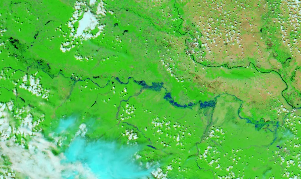
Record-breaking floods in Serbia, Croatia and Bosnia and Herzegovina are visible from space in a new satellite image.
Taken May 19, the image shows rivers swollen by heavy rains. The flooding is the worst in the region since record-keeping started more than a century ago. Three months' worth of rain fell in the region in a matter of three days, according to the BBC. The rain has now cleared, but floodwaters continue to move downstream, so Balkan towns are still bracing for higher waters. Meteorologists expect the flooding in Belgrade, the capital of Serbia, to worsen this week.
Dozens have died, and tens of thousands have evacuated their homes. Complicating the response, the floodwaters have triggered thousands of landslides in this mountainous region. What's worse, buried landmines from the Bosnian War of 1992 to 1995 may have shifted in these slides, posing a danger to rescuers and survivors alike. [Earth from Above: 101 Stunning Images from Orbit]
The flooding is affecting several major waterways, including the Sava River, the Drina River and the Bosna River. The Danube, Europe's second-longest river, is rising as well, but experts believe it will remain contained.
The new NASA image of the disaster comes courtesy the space agency's Aqua satellite, according to NASA's Earth Observatory. The Moderate Resolution Imaging Spectroradiometer aboard Aqua captured the extent of the flooding. Vegetation is seen in green and bare ground in brown. Water appears black.
The Danube River is the dark band cutting across the image on the upper right. The river snaking across the middle of the image is the Sava, which has been most affected by the flooding so far. Extending off the Sava on the right is the Drina River; to its left is the Bosna. Croatia is on the left of the image, bordered by Bosnia and Herzegovina and then Serbia on the right.
Sign up for the Live Science daily newsletter now
Get the world’s most fascinating discoveries delivered straight to your inbox.
Cause and response
According to Earth Observatory, extra-tropical cyclone Tamara brought Mediterranean moisture to the region, causing the floods. A second image, this one acquired by NASA's Aqua satellite on May 18, 2013, shows the rivers in a typical, non-flood stage.
A satellite image aquired in May 2013 shows the Balkans without flooding.
(Image credit: NASA Earth Observatory image by Jesse Allen, using data from the Land Atmosphere Near real-time Capability for EOS (LANCE))
Landslides and land mines aren't the only dangers facing residents in the aftermath of the flooding. About a quarter of Bosnians lack access to clean water in the wake of the flooding, according to news reports. And tens of thousands of bodies of drowned livestock are posing a health risk, as well. The governments of Serbia and Bosnia are calling for international aid to help what is sure to be a long recovery.
Stephanie Pappas is a contributing writer for Live Science, covering topics ranging from geoscience to archaeology to the human brain and behavior. She was previously a senior writer for Live Science but is now a freelancer based in Denver, Colorado, and regularly contributes to Scientific American and The Monitor, the monthly magazine of the American Psychological Association. Stephanie received a bachelor's degree in psychology from the University of South Carolina and a graduate certificate in science communication from the University of California, Santa Cruz.