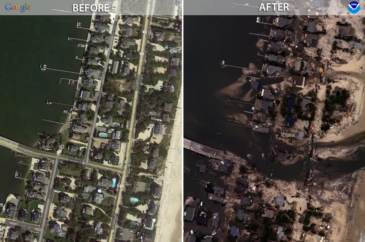
When Hurricane Sandy's powerful storm tide pummeled New Jersey, 70 percent of the state's old submerged marshes flooded, researchers reported Monday (Oct. 28) at the Geological Society of America's annual meeting in Denver.
About 25 percent of those marshes were developed, and two-thirds of that development took place between 1995 and 2007, said Joshua Galster, a geomorphologist at Montclair State University in New Jersey. "A lot of these areas were being developed when we really should have known better," Galster said.
Submerged marshes are natural storm barriers that lessen the force of incoming waves. A submerged marsh is typically defined by its low elevation. During normal high tides, the land is often underwater, but the grasses and plants growing in the sand and muck poke up above the sea surface.
Latest Videos From
Before Hurricane Sandy hit, Galster and students at Montclair State University had compiled a database of all the former submerged marshes and swamplands in New Jersey and Delaware. The students digitized 100-year-old historic maps to see the extent of marshes lost to development.
The team found 197 square miles (510 square kilometers) of land in both states was submerged marsh, once periodically underwater. Now, 820 miles (1,320 km) of roads (a proxy for development) cover the marshlands, Galster said.
"That is a rather staggeringly high number," he said.
After the big storm on Oct. 29, 2012, the researchers compared storm-surge records from the U.S. Geological Survey to their historic submerged marsh maps.
"That's when it became really interesting," Galster said.
Although 70 percent of the historic submerged marshes flooded during the storm, the extent of the damage on the Jersey Shore varied. (The researchers did not have historic records of coastal development in Delaware.) [Jersey Shore: Before and After Hurricane Sandy]
"The Jersey Shore is not entirely developed," Galster said. "If we look at a state park, it fared much better. The damage was all right next to the ocean, as opposed to [also] on the landward side and on the mainland. We didn't have as much geomorphic change."
Galster plans to expand the study to include more of the Atlantic Coast, and look at elevation changes after Hurricane Sandy in the submerged marshes. Submerged marshes can grow with sea level rise by adding sand, and Galster wants to see if the marshes gained or lost sand during the storm.
History of extreme storms
Hurricane Sandy's storm surge was the biggest to hit New York City since 1900. Now, geologists are plumbing for past storms, preserved in sediments deep beneath existing ponds and beaches.
These layers of sand can be difficult to interpret — does a shift to coarser sand indicate a storm passing through? By looking at the sand left behind by Sandy, and comparing it to past storm layers, geologists are getting a better handle on the history of extreme hurricanes in the area, researchers from several universities reported at the GSA meeting.
For example, comparing sand deposits left by New York City's 1821 hurricane to those left by Hurricane Sandy reveals the 1821 storm produced a much larger storm surge, said Christine Brandon, a graduate student at the University of Massachusetts at Amherst. "This was a much-faster-moving storm [than Sandy]," Brandon said.
Brandon analyzed sediment pulled from ponds and lakes on Staten Island's southern coast. Her research confirms a newspaper account of the 1821 storm that reports a 13-foot (4 meters) water-level rise in the East River. Though the report said the flooding raced through New York in only an hour, Brandon's model shows the East River storm surge probably took two hours, she told LiveScience. And it hit at low tide, so the flooding could have been worse. (Hurricane Sandy's storm surge was boosted by a high tide.)
"Even though Hurricane Sandy was the biggest event that happened in our lives, it is about on par with things that happened in the past," Brandon said.
Email Becky Oskin or follow her @beckyoskin. Follow us @livescience, Facebook & Google+. Original article on LiveScience.

 Live Science Plus