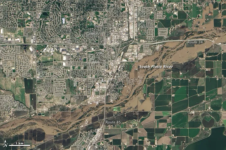
Flood waters have been receding along the South Platte River near Greeley, Colo., after the 100-year flooding event in the area in mid-September 2013, but the muddy brown waters could still be seen beyond the normal banks of the waterway when the the Operational Land Imager (OLI) on the Landsat 8 satellite snapped an image of the region on Sept. 17. "The image shows that the flood has washed away roads, including sections of U.S. Highway 34," according to NASA's Earth Observatory.
(Image credit: NASA Earth Observatory image by Jesse Allen and Robert Simmon)
After historic flooding swept Colorado, washing out roadways and bridges in Boulder and Larimer counties, the Colorado Department of Transportation is in a race against Mother Nature to reopen major routes in time for winter tourism.
Colorado, which spans a great deal of the southern Rocky Mountains, can receive the peak of its snowfall in the fall months, creating a rush for local ski and winter sport resorts.
While a second snow season typically arrives in late winter for the area, getting skiers on the slopes in the first half of the season is critical to the industry and local economy.
Large sections of roadway on state routes were dragged away by the flood waters in mid-September, while others were clogged by inches of standing water.
Still, some areas are not accessible by crews at all.
Though detours have been constructed, the temporary routes force travelers around the mountains and have added more than an hour of travel time to some routes.
Sign up for the Live Science daily newsletter now
Get the world’s most fascinating discoveries delivered straight to your inbox.
"At one point, we had 30 different roadway closures up in northeastern Colorado that included a variety of state highways," Ashley Mohr, public relations manager for the Colorado Department of Transportation (CDOT), said.
CDOT has set Dec. 1, 2013, as their goal for construction completion, but it's a race against time and Mother Nature to get roadways repaved, reopened or temporarily reconstructed.
If the coming weeks continue to yield unfavorable conditions, the quickly approaching winter season could spell disaster for the tourism industry.
"Just one day of not having those roads open will definitely affect tourism, so we're just doing everything we can to get those highways open in some facet as soon as we can," Mohr said.
Construction has already been hampered by continuing precipitation, resulting in work and paving delays for contractors.
"Anything with moisture we definitely don't want and unfortunately we're getting it in two different forms right now," Mohr said.
Adding insult to injury, snow began falling in the mountains of Colorado in mid-September, and the threat for more is looming.
"It's already started and we're going to continue to see it through October," according to Paul Pastelok, AccuWeather.com expert long-range forecaster.
"If the pattern is right, however, the snow should ease back a little bit in November then pick back up again in December and January," he said.
With the worst of the storms through December forecast to occur over the northern Rockies, however, it's promising that the area will have some extended periods where they can work on the roads, Pastelok said.
More than 35 bridges on major routes have been impacted by the flooding, some of which are imperative in moving traffic through major travel arteries.
Officials are hoping that the precipitation will relent in time, becoming more conducive for the construction plans.
In September alone, the Boulder area has received more than 16 inches of precipitation, shattering previous year-to-date and all-time monthly accumulation records.
"We're really trying to beat the clock on the winter weather, but at the same time, we're still getting rain. We're getting very heavy winds today; we've got actually a different section of interstate out east that's closed due to dust," Mohr told AccuWeather.com Monday. "So, we're just praying at this point that the nasty weather kind of calms down a little bit so we can get our work done."
Cost estimates for the reparations have not yet been established.
"Obviously, it's going to be millions of dollars, but we haven't really gotten our heads around that yet," Mohr said.
AccuWeather.com's full-length 2013 U.S. Winter Forecast will be released in early October.
With much of the country experiencing an unseasonably warm winter, fears of climate change come to mind. See how well you understand recent weather, climate and the difference between them.