A new series of NASA images illustrates how Earth's plant growth has changed over the past 11 years.
The images are part of the series, "World of Change: Global Biosphere." They show the yearly changes in plant growth between 1999 and 2008 based on data on chlorophyll on the ocean's surface and vegetation density on land. Scientists use the images to study Earth's carbon cycle – the uptake and release of carbon by Earth's biosphere.
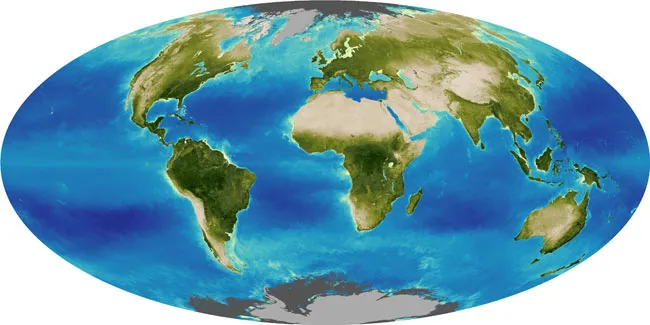
The global biosphere, or the sum of all ecosystems that support life on Earth, is in constant flux. The images show changes in chlorophyll, the green pigment in plants allows photosynthesis to occur, averaged over each year. Changes in land growth are shown as a vegetation index, a blend of the variation between the summer flourishes and the slow growth winter.
Latest Videos From
The NASA maps show dense vegetation areas on land as dark green and high concentrations of chlorophyll in the ocean as yellow. The highest vegetation index is found around the tropical regions near the equator. Chlorophyll is also abundant near the equator and near Earth's poles.
The maps can also be used to compare plant growth in specific regions over time. NASA points out that in Australia, the 2008 map shows more vegetation than the 2002 map, indicating that 2008 was a more productive year, either due to more rainfall or mild temperatures.
Scientists use the global biosphere measurements to study the planet's net primary productivity – the amount of carbon that plants use to grow. As carbon dioxide accumulates in the atmosphere, scientists can study how much is offset by the global biosphere.
The NASA images were created using ocean chlorophyll data collected by NOAA satellites through the Sea-viewing Wide Field-of-view Sensor (SeaWiFS) Project, as well as vegetation data from the Global Inventory Modeling and Mapping Studies (GIMMS) project at NASA's Goddard Space Flight Center.

 Live Science Plus