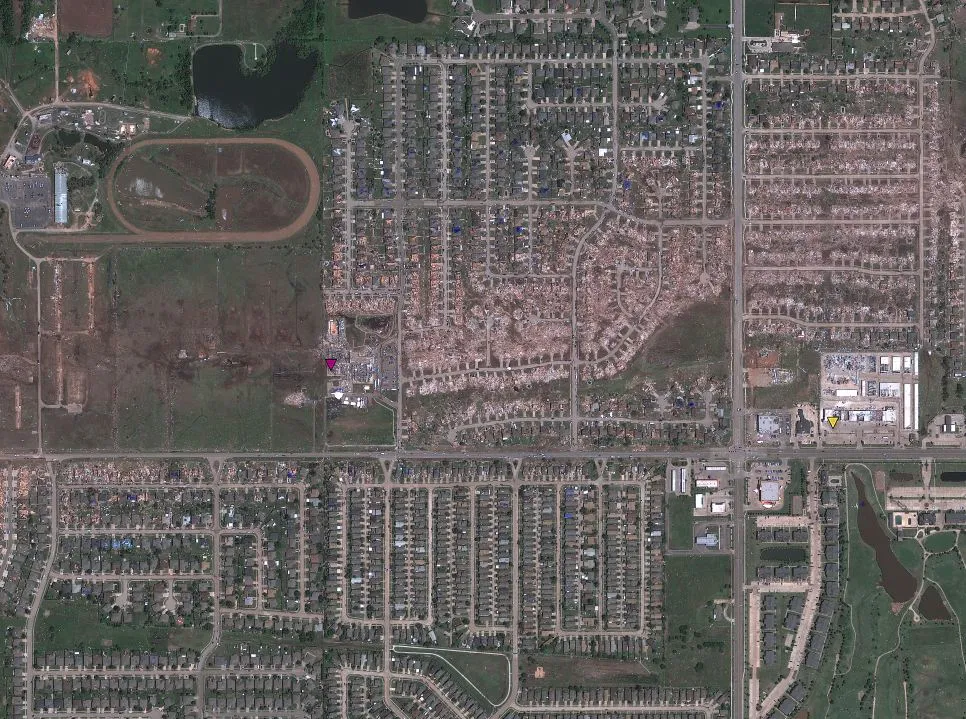
A satellite image available via Google Maps shows the path that a deadly tornado took as it tore through Moore, Okla., on Monday (May 20) and the scar it etched into the suburban landscape.
In the Google Maps image, you can also click on tabs to see local reports of damage — purple tabs indicate the most severe damage.
At its most intense, the twister was a rare EF5, the most devastating type of tornado. Its winds likely exceeded 200 mph (322 km/h) when it barreled through Moore.
Latest Videos From
The tornado cleared a path up to 1.3 miles (2 kilometers) wide along a 17-mile-long (27 km) stretch of central Oklahoma, according to the National Weather Service. The twister touched down 4.4 miles (7.1 km) west of Newcastle at 2:45 p.m. CDT and ended 4.8 miles (7.7 km) east of Moore, a southern suburb of Oklahoma City, at 3:35 p.m. CDT.
At first, the tornado caused little damage on the ground. But it ramped up quickly, intensifying to EF4 levels in about 10 minutes, the NWS said. The twister produced widespread EF4 scale damage, as can be seen in the image in the center of its path.
At least 24 people were killed by the tornado, and more than 300 were injured, according to local officials. The precise amount of damage will take several days to fully evaluate, but as this and other images of the Moore tornadoshow, it was severe.
EF5 tornadoes are strong enough to blow away big houses and collapse tall buildings. EF4 tornadoes can level sturdy homes and send cars and other large objects flying.
"The debris ball from the tornado, as seen on Doppler radar, expanded to over 2 miles in diameter, and debris was carried over 100 miles [160 km] from Moore," Jeff Masters of Weather Underground wrote on his WunderBlog.
Email Douglas Main or follow him on Twitter or Google+. Follow us @OAPlanet, Facebook or Google+. Original article on LiveScience's OurAmazingPlanet.