
 Live Science Plus


Best Earth Images of the Week - Nov. 2, 2012

Fighting to the end

Earth-shaking force
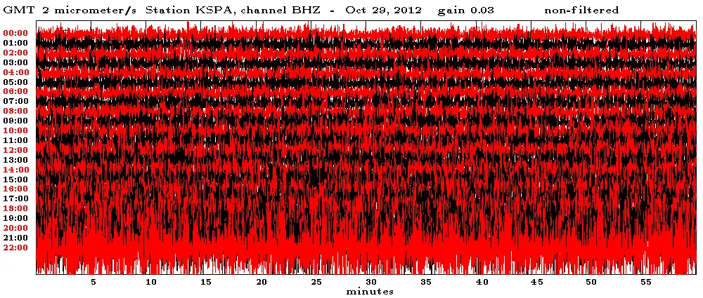
As heavy surf hammered the Northeast Monday afternoon before Hurricane Sandy's landfall, the weather was peaceful in northern Pennsylvania.
At Keystone College, in the small town of La Plume, a seismometer scratched out a warning. Even more than 100 miles (161 kilometers) inland, the instrument picked up the power of waves churned by Sandy's winds.
[Full Story: Sandy's Punishing Waves Detected by Earthquake Monitor]
Frighteningly large

A series of satellite photos of Hurricane Sandy have captured eye-popping views of the frightening storm from space, showing the tempest in relation to the entire planet Earth, as well as its appearance at night.
The new satellite views of Hurricane Sandy were snapped Sunday (Oct. 28) by the GOES-13 weather satellite and the powerful Suomi NPP Earth-watching satellite. Both satellites are used by NASA and the National Oceanic and Atmospheric Administration to monitor Earth's weather.
[Full Story: Hurricane Sandy's Menacing Size on Earth Revealed in Satellite Photos]

Under cover of night

All of NASA's electronic eyes in space seem trained on Hurricane Sandy's march across the Northeast and Mid-Atlantic.
NOAA's GOES-13 satellite captured a visible image of post-tropical cyclone Sandy rolling overland this morning (Oct. 30) at 6:02 a.m. EDT. The powerful storm lost its hurricane status on Monday as its source of power shifted from warm ocean waters and air to interacting with a cold front along the coastline.
[Full Story: Satellites Show Sandy Clobbering East Coast]
Black out

When Sandy's punishing winds and waves smacked into New Jersey and New York Oct. 29, they knocked out power to millions.
In the immediate aftermath of Hurricane Sandy, more than 8 million people were thought to be without power. Some 90 percent of Long Island lost power, as well as numerous communities in New Jersey and all of Lower Manhattan ?which created strange views of the island's iconic skyline from neighboring boroughs and New Jersey.
[Full Story: Sandy Power Outages Spotted from Space]
Under siege
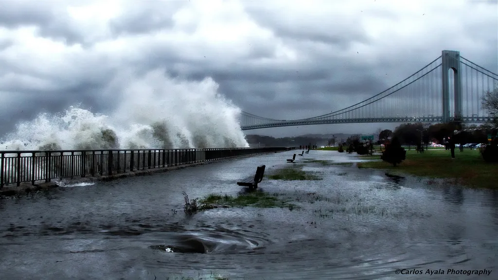
A striking image of Verrazano Bridge in Brooklyn as Hurricane Sandy approaches on Oct. 29, 2012.
[Full Story: Sandy Lives Up to Hype: Predictions Were on Track]
National effects

A beautiful animation just out shows Hurricane's Sandy's wind gusts as the Frankenstorm moves up the East Coast.
Screenshots taken from the map animation capture Sandy's winds advancing north last night and this morning (Oct. 29).
The map was created by Fernanda Viégas and Martin Wattenberg, artists/technologists who lead Google's "Big Picture" visualization research group in Cambridge, Mass., according to their website.
[Full Story: A Stunning Map of Hurricane Sandy's Winds ]
