Monsoon Transforms River
Get the world’s most fascinating discoveries delivered straight to your inbox.
You are now subscribed
Your newsletter sign-up was successful
Want to add more newsletters?
Delivered Daily
Daily Newsletter
Sign up for the latest discoveries, groundbreaking research and fascinating breakthroughs that impact you and the wider world direct to your inbox.
Once a week
Life's Little Mysteries
Feed your curiosity with an exclusive mystery every week, solved with science and delivered direct to your inbox before it's seen anywhere else.
Once a week
How It Works
Sign up to our free science & technology newsletter for your weekly fix of fascinating articles, quick quizzes, amazing images, and more
Delivered daily
Space.com Newsletter
Breaking space news, the latest updates on rocket launches, skywatching events and more!
Once a month
Watch This Space
Sign up to our monthly entertainment newsletter to keep up with all our coverage of the latest sci-fi and space movies, tv shows, games and books.
Once a week
Night Sky This Week
Discover this week's must-see night sky events, moon phases, and stunning astrophotos. Sign up for our skywatching newsletter and explore the universe with us!
Join the club
Get full access to premium articles, exclusive features and a growing list of member rewards.
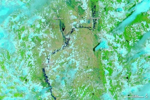
Arising from glaciers in the remote mountains of northern Burma (Myanmar), the Irrawaddy River (also known as the Ayeyarwady or Ayeyarwaddy) typically experiences its lowest water level in February, and its highest water level in August. Summertime snow and glacier melt contribute to the higher water level, but the strongest driver of fluctuating water level is the Asian summer monsoon.
Monsoon rains had swelled the Irrawaddy River and its tributary, the Chindwin River, by early August 2011. The Moderate Resolution Imaging Spectroradiometer (MODIS) on NASA's Aqua satellite captured the top image on August 2, 2011. The bottom image shows the same region on March 6, 2011, when river levels were much lower.
Both images use a combination of visible and infrared light to increase contrast between water and land. Water varies in color from electric blue to navy. Depending on land cover, areas not under water appear green or brown (vegetation is bright green). Clouds range in color from white to pale blue-green.
Despite some cloud cover on August 2, the Irrawaddy and Chindwin Rivers are clearly swollen compared to their water levels months earlier. Monsoon rains typically fall in this region between May and October, watering both rivers and plants. In early August 2011, Myanmar Times reported that floods in Burma had caused several deaths and forced thousands of residents to evacuate, yet the current floods were not as severe as those of 2010 or 2008.
- Haboob Hubbub: The Science of the Monster Phoenix Dust Storm
- Dust Storm Hits Phoenix
- Surprising Threat Looms for Wildfire-Scorched Arizona: Rain
Get the world’s most fascinating discoveries delivered straight to your inbox.

