Groovy Pattern Cuts Through Clouds
Get the world’s most fascinating discoveries delivered straight to your inbox.
You are now subscribed
Your newsletter sign-up was successful
Want to add more newsletters?
Delivered Daily
Daily Newsletter
Sign up for the latest discoveries, groundbreaking research and fascinating breakthroughs that impact you and the wider world direct to your inbox.
Once a week
Life's Little Mysteries
Feed your curiosity with an exclusive mystery every week, solved with science and delivered direct to your inbox before it's seen anywhere else.
Once a week
How It Works
Sign up to our free science & technology newsletter for your weekly fix of fascinating articles, quick quizzes, amazing images, and more
Delivered daily
Space.com Newsletter
Breaking space news, the latest updates on rocket launches, skywatching events and more!
Once a month
Watch This Space
Sign up to our monthly entertainment newsletter to keep up with all our coverage of the latest sci-fi and space movies, tv shows, games and books.
Once a week
Night Sky This Week
Discover this week's must-see night sky events, moon phases, and stunning astrophotos. Sign up for our skywatching newsletter and explore the universe with us!
Join the club
Get full access to premium articles, exclusive features and a growing list of member rewards.
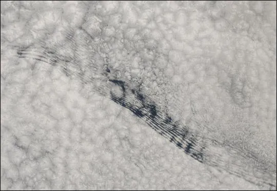
This true-color scene shows a deck of marine stratus clouds over the South Atlantic Ocean somewhere off the west coast of Angola, Africa, according to a NASA statement. Stratus are low, relatively flat clouds, up to 1,980 m (6,500 feet) in altitude, that generally spread out to form a layer over a large region. Stratus cloud layers often form along coastlines.
Notice the grooved pattern running from upper left (northwest) to lower right (southeast) through the marine stratus clouds in this scene. It is unusual to see such sharp boundaries in clouds , particularly when they extend in such a regular pattern for such a long distance. So far, consensus is the patterns cannot be due to gravity waves, as the scene is not over land, nor are they due to an air mass advecting horizontally through the cloud deck. So the question remains: What made this pattern?
This image was acquired by the Moderate Resolution Imaging Spectroradiometer (MODIS), aboard NASA's Aqua satellite, on August 28, 2003. The high-resolution image provided above is 500 meters per pixel. The MODIS Rapid Response System provides this image at MODIS' maximum spatial resolution of 250 meters.
Get the world’s most fascinating discoveries delivered straight to your inbox.

