It's quick and easy to access Live Science Plus, simply enter your email below. We'll send you a confirmation and sign you up for our daily newsletter, keeping you up to date with the latest science news.
In the wake of the magnitude 9.0 earthquake and resulting tsunami that struck northeastern Japan last Friday (March 11), ocean waters flooded croplands and settlements lining the Kitakami River.
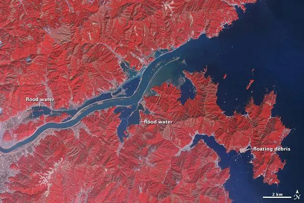
The Advanced Spaceborne Thermal Emission and Reflection Radiometer (ASTER) on NASA's Terra satellite captured these false-color images before and after the tsunami . Above is the after image, taken on Monday (March 14); below is the before image, taken on Jan. 16.
(Image credit: NASA)
The images combine infrared, red, and green wavelengths of light to form a false-color image that distinguishes between muddy water and land. Water is blue. Buildings and paved surfaces appear in shades of blue-gray. Fallow fields appear in shades of beige and brown. Vegetation is red, and the brighter the red, the more robust the vegetation. (Brighter shades of red in March and duller shades in January result largely from the difference in season.)
In the March image, water has spilled over the banks both north and south of the river. Although agricultural fields appear to have escaped the flooding farther inland (image left), some fields closer to the ocean have seemingly disappeared into the sea, a NASA statement said.
North of the Kitakami, floodwaters extend far enough inland to create what looks like a parallel river. Near the coast, only the rugged peaks rising above the floodplains have escaped inundation.