It's quick and easy to access Live Science Plus, simply enter your email below. We'll send you a confirmation and sign you up for our daily newsletter, keeping you up to date with the latest science news.
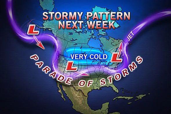
A major storm may come together to bring wind-whipped snow to the Upper Midwest and Great Lakes region early next week, while severe storms could ignite on the southern edge.
Minnesota, Wisconsin, Michigan, Illinois, Indiana and Ohio may get travel-disrupting snow from the storm during the Monday-Tuesday time frame of next week.
There is potential for snow to fall in Chicago, Green Bay, Indianapolis and Detroit. Gusty winds up to 40 mph could reduce visibility further and add to travel impacts from the storm.
On the back edge of the storm, some snow may even reach areas farther south such as St. Louis and Cincinnati.
By Tuesday night and Wednesday, the storm may swing across Canada, bringing snow from the northern mid-Atlantic and much of New England to Quebec. Again, gusty winds may accompany the round of snow, adding to travel disruptions.
Sign up for the Live Science daily newsletter now
Get the world’s most fascinating discoveries delivered straight to your inbox.
Strong to severe storms may also be a threat along the southern edge of the storm; however, a limiting factor will be cold air that will surge south over this weekend. The cold air will flush out moisture that has been in place recently to fuel severe thunderstorms.
"The Gulf Coast is most likely to regenerate conditions favorable for severe weather," AccuWeather Expert Senior Meteorologist Dan Kottlowski said.
Southeastern Louisiana, Mississippi, Alabama and perhaps Tennessee may be in the path of damaging thunderstorms on Tuesday.
The parade of storms will continue through late next week.
Another, potentially bigger, storm will strengthen across the Plains next Thursday. A round of heavy snow may be in store for portions of the Plains, Midwest and Great Lakes. Chicago may get a second round of snow.
The storm could move on to spread snow into the mid-Atlantic and New England by next Friday.
With much of the country experiencing an unseasonably warm winter, fears of climate change come to mind. See how well you understand recent weather, climate and the difference between them.