This article was provided by AccuWeather.com.
Sanba crashed into the Japanese island of Okinawa early Sunday morning, local time, bringing damaging winds and torrential rain. The storm then made a second landfall in South Korea Monday, local time.
The storm has since weakened to a tropical storm.
Latest Videos From
Sanba, the most powerful typhoon of the season at its peak, made its first official landfall in Okinawa with winds equivalent to a Category 3 hurricane. The storm ripped across the island with a fury, unleashing 6-9 inches of rain.
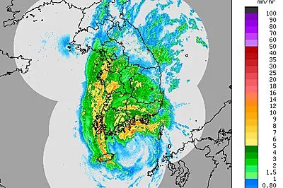
Reports of rainfall rates well exceeding an inch an hour came from multiple points on the island. The massive amounts of rainfall, combined with impacts of storm surge and rough surf, led to some flooding.
Major damage was not expected to occur, however, as Okinawa is well protected from typhoons by large seawalls and other preventative measures.
The highest sustained wind measured in Okinawa was 85 mph, while a gust to 127 mph was recorded.
Sanba moved on to unleash more than a foot of rain in Jeju City of the South Korean island of Jeju. The Korea Times reports that another town in Jeju Island was deluged by 32 inches of rain.
Heavy rain continues to fall as Sanba departs eastern South Korea for the Sea of Japan.
"Sanba remains a heavy rain threat through Tuesday night [local time]. A swath of 3-6 inches of rain is expected all the way into southeastern Russia," AccuWeather Senior Meteorologist Eric Wanenchak said.
Content contributed by AccuWeather Meteorologist Meghan Evans.
© AccuWeather.com. All rights reserved. More from AccuWeather.com.