It's quick and easy to access Live Science Plus, simply enter your email below. We'll send you a confirmation and sign you up for our daily newsletter, keeping you up to date with the latest science news.
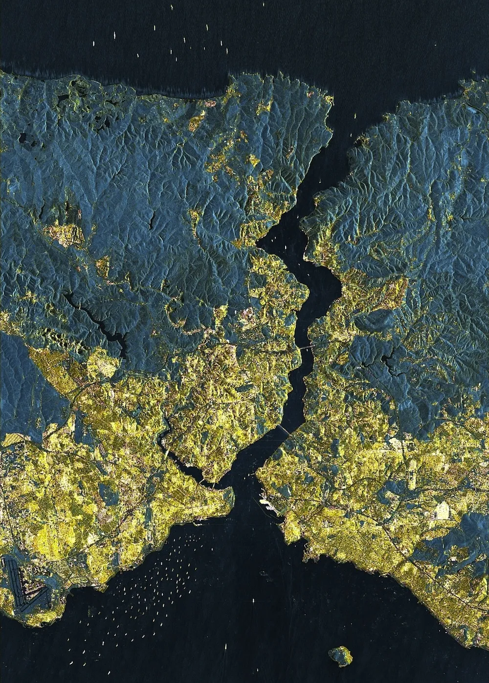
A German satellite image provides a detailed view of Istanbul from more than 300 miles (500 kilometers) up. There is dense housing where yellow is predominates. In the city itself, only a few areas remain undeveloped and are thus shown in green.
A newly released satellite image reveals Istanbul, the largest city in Turkey at 15 million inhabitants, is quickly becoming a "megacity" covering almost 700 square miles (1,800 square kilometers).
"Megacities let us take a look into our future, when we have to expect that cities that today have 'only' two to five million inhabitants will grow at an explosive rate," Hannes Taubenböck, of DLR's German Remote Sensing Data Center, said in a statement.
In this image, acquired by the German Aerospace Agency's TerraSAR-X radar satellite, the populated urban areas are colored yellow because the city's buildings reflect the satellite's signals, giving an accurate view of its immensity. [Amazing Science Images]
The city's airport is clearly visible in the bottom left corner of the image — the darker blue color indicates where there are few buildings around the runways. Even the boats are visible dotting the city's surrounding seas.
Over time, the population and urban sprawl of Istanbul has expanded immensely. The top image shows the population spread in 1975, the middle in 1990 and the bottom image is from 2010.
(Image credit: DLR)
The Bosphorus Suspension Bridge and the Fatih Sultan Mehmet Bridge, built in 1973 and 1988, respectively, have enabled its population to expand across the Bosphorus Strait, the stretch of water extending from the Black Sea at the top to the Sea of Marmara at the bottom.
"These connections to the city center on the European side have generated enormous growth on the Asian side," Taubenböck said. "Over the last 35 years, the area of Istanbul has tripled."
Radar satellites like TerraSAR-X, which was launched in 2007, are useful because they can "see" through clouds and darkness, while typical remote-sensing instruments rely on visible light.
Sign up for the Live Science daily newsletter now
Get the world’s most fascinating discoveries delivered straight to your inbox.
You can follow LiveScience staff writer Jennifer Welsh on Twitter @microbelover. Follow LiveScience for the latest in science news and discoveries on Twitter @livescience and on Facebook.
Jennifer Welsh is a Connecticut-based science writer and editor and a regular contributor to Live Science. She also has several years of bench work in cancer research and anti-viral drug discovery under her belt. She has previously written for Science News, VerywellHealth, The Scientist, Discover Magazine, WIRED Science, and Business Insider.

 Live Science Plus