Having trouble seeing the forest for the trees? A newly released United States map might be able to help.
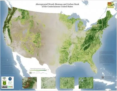
The map, created by Woods Hole Research Center (WHRC) scientists, is the most precise representation yet of the height and coverage of U.S. forests and woodlands. The data will provide a baseline for understanding both forest resources and carbon flux, study leader Josef Kellndorfer of WHRC said in a statement.
"This dataset will be useful to foresters, wildlife ecologists, resource managers and scientists alike," Kellndorfer said.
Latest Videos From
Forests store carbon in living vegetation, dead wood and leaf litter. Understanding this carbon storage is important for understanding how carbon cycles in and out of the atmosphere, and thus refining predictions about climate change. Understanding forest cover can also help researchers conserve species, understand wildfire risk and manage timber production, said WHRC study researcher Wayne Walker.
"Maps of key forest attributes like canopy height and carbon stock have not existed for the U.S. at this level of spatial detail," Walker said in a statement.
The high-resolution map was pieced together using 2000-2001 data from NASA satellites and ground-based forest surveys. The full dataset, available at whrc.org/nbcd, contains information on the height of forests, the amount of vegetation aboveground and the amount of carbon stored in that biomass. The 2000 baseline should help researchers monitor changes in forest cover over time, Kellndorfer said.
You can follow LiveScience senior writer Stephanie Pappas on Twitter @sipappas. Follow LiveScience for the latest in science news and discoveries on Twitter @livescience and on Facebook.

 Live Science Plus