It's quick and easy to access Live Science Plus, simply enter your email below. We'll send you a confirmation and sign you up for our daily newsletter, keeping you up to date with the latest science news.
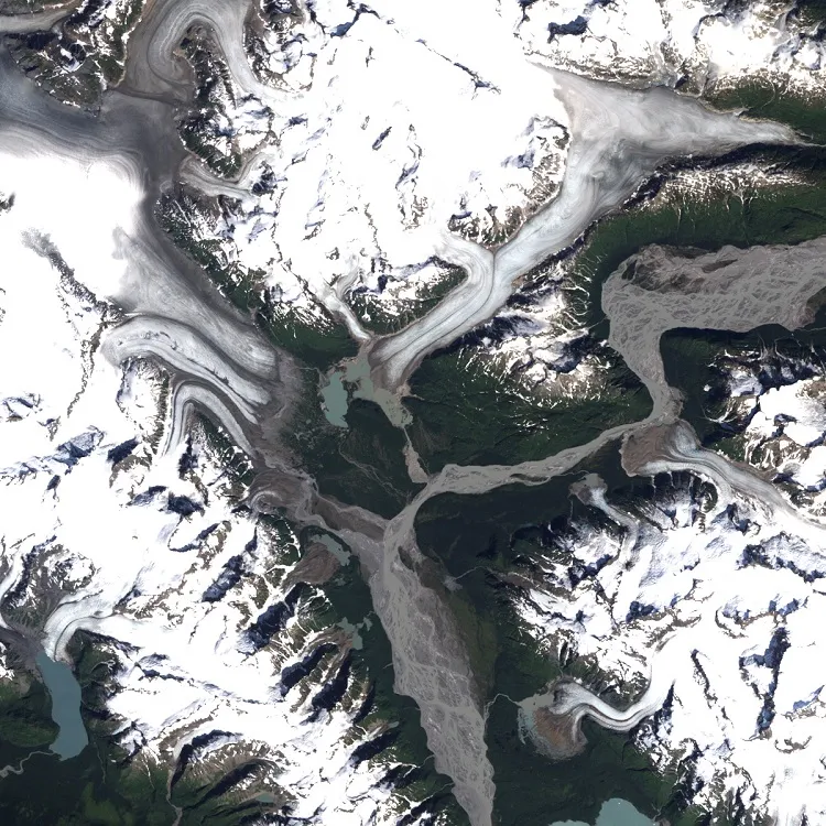
In a remote corner of southeastern Alaska, two glaciers are retreating at a rapid pace. Compared with a vintage satellite photo of the region, an image taken from space last year reveals just how much the glaciers have shrunk over the past 26 years.
The Novatak and East Novatak glaciers in the Brabazon Range have retreated by 0.6 miles (1 kilometers) and 1.2 miles (2 km), respectively. NASA's Landsat 5 satellite captured the first image on Aug. 22, 1987, and Landsat 8 captured the second image on Aug. 13, 2013. NASA's Earth Observatory released the images yesterday (Aug. 14).
The two glaciers are fueled by snow that falls at higher elevations, compresses into ice and slides down through valleys. The ice melts on its way down and collects at the bases of the glaciers. The ice melt forms a pool of crystal-blue water, known as a proglacial lake. The blue coloration comes from soft silt called "rock flour" that is produced when glacier ice rubs against rock. [Image Gallery: Get a Glimpse of Remote Alaska]
The bases of both glaciers have noticeably retreated. The photos show that as East Novatak retreated over the years, it cut off one of the channels that supplied ice melt and rock flour to the proglacial lake. The western part of the lake turned dark blue without fresh rock flour flowing in, and the eastern side of the lake expanded and changed shape, according to NASA scientists.
In 2013 the glacier on the left retreated 0.6 miles (1 kilometer) and the glacier on the right retreated 1.2 miles (2 km).
(Image credit: NASA Earth Observatory)
Most of East Novatak does not reach more than 3,280 feet (1,000 meters) in altitude, and the snowfall that fuels it comes from a relatively low elevation. The Earth Observatory pointed to a blog post by Mauri Pelto, a glaciologist at Nichols College in Massachusetts, who says Alaskan glaciers that rely on snow from lower elevations are especially vulnerable to climate change.
These are not the first retreating Alaskan glaciers that scientists have noticed. Glaciers in the area are definitely losing mass, but the changes are complex and difficult to measure in such remote areas, according to the U.S. Geological Survey. It's also difficult to identify an overall trend because Alaska is home to many different types of glaciers that behave in unique ways.
NASA is using an instrument called the Multiple Altimeter Beam Experimental Lidar (MABEL) that can be fixed to an aircraft to measure the elevation of Arctic glaciers and gain a better understanding of how they are changing over time. Scientists will use MABEL on a mission planned for 2017 that will measure the thickness of sea ice covering the Arctic.
Sign up for the Live Science daily newsletter now
Get the world’s most fascinating discoveries delivered straight to your inbox.
Kelly Dickerson is a staff writer for Live Science and Space.com. She regularly writes about physics, astronomy and environmental issues, as well as general science topics. Kelly is working on a Master of Arts degree at the City University of New York Graduate School of Journalism, and has a Bachelor of Science degree and Bachelor of Arts degree from Berry College. Kelly was a competitive swimmer for 13 years, and dabbles in skimboarding and long-distance running.