


Grand Canyon: Take a Hike Through Geological Time
Journey through time

As sunrise begins to show the first light of day, hikers take their first steps through geological time in what is known as one of the Seven Wonders of the World. Here among the rocks of a magnificent mile deep gorge on the South Kaibab Trail along the South Rim of Grand Canyon National Park one starts a journey through time. Hikers step off onto the trail at an elevation of 7,250 feet (2,200 meters). The trail is steep, descending 4,860 feet (1,481 m) in just 6.3 miles (10.1 kilometers) to the Colorado River at the bottom of the canyon.
To the Colorado River

Here at the trailhead, the route to the Colorado River cuts through Kaibab Limestone, the youngest of the rock formations found in the Grand Canyon, having been laid down under shallow ancient seas some 270 million years ago toward the end of the Paleozoic Era. This is the grayish-white to cream-colored rock that park visitors stand on and hikers walk over when pushing off onto the trail toward their first destination, Cedar Ridge.
Layered canyon

Cedar Ridge is 1.5 miles (2.4 km) from the rim and is a vertical drop into the canyon of 1,000 feet (305 m). Hikers pass through not only the 300-400-foot (90-100-m) layer of Kaibab Limestone but also the other top layers of canyon strata: the Toroweap Formation, Coconino Sandstone and Hermit Shale. Signage along the way points out the joining of the layers as the texture of the rock changes beneath the hiker's feet.
Cedar Ridge
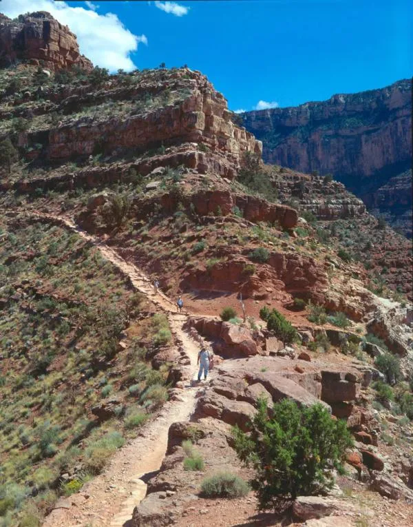
Cedar Ridge is located in the Hermit Shale strata at an elevation of 1,140 feet (350 m) and was deposited on a broad coastal plain laid down by freshwater streams some 280 million years ago. The thin layer made of iron oxide, silt and mud is over-saturated with the fossils of ferns, winged insects and tracks of small vertebrate animals. It is here at Cedar Ridge that the hiker first feels what it is like to truly be IN the Grand Canyon.
Following the trail

Just a half mile down the trail from Cedar Ridge is found the prominent geological landmark of the Kaibab Trail, O'Neil Butte. Located on a saddle of Red Wall Limestone, O'Neil Butte is named for the famous Arizona Rough Rider, Buckey O'Neil. Another mile down the trail sees our geological time traveler pass through the Supai Group strata and arrive at Skeleton Point. Here, 3 miles (5 km) from the trailhead and 2,000 feet (610 m) below the starting point, the Colorado River first comes into view. This is also the beginning of the strata known as Muav Limestone.
Redwall Limestone

The Redwall Limestone found at the level of Skeleton Point is about 335 million years old and is possibly the most prominent rock layer found in the Canyon. Here are found 400-500-foot (120-150-m) cliffs that act as a natural barrier between the upper and inner region of the Grand Canyon. The deep reddish color is the result of iron oxides leeching that have stained the actual light beige and gray color of the rock. The Redwall Limestone is rich with fossils of clams, brachiopods, snails, fish and trilobites. Here too are found unique cave and arch formations that are a photographer's delight.
Sharp descent

After Skeleton Point, the trail down through time begins a sharp decent through a series of switchbacks toward the canyon's inner gorge. For the next 1.5 mile (2.4 km) the trail descends 1,200 feet (370 m) and passes through strata of Muav Limestone, Bright Angel Shale and Tapeats Sandstone. Ancient seas between 515 million and 545 million years ago also laid these, the last of the Cambrian Period rock layers, down. They are all a part of a landscape known as the Tonto Group and fossils of ancient marine trilobites and brachiopods are found throughout the strata.
Get the world’s most fascinating discoveries delivered straight to your inbox.
Inner Gorge

Our geological time traveler now enters the canyon's ancient Inner Gorge. The Inner Gorge is made up only of metamorphic and igneous rocks from the Precambrian time of about 2,000 million years ago. During this time thousands of feet of mud, ash, sand and silt were laid down in shallow basins. Some 1,700 million to 1,600 million years ago the pressure of plate tectonics heated and pressed these marine layers into the metamorphic rock that is now exposed in the Inner Gorge. There are no fossils found in these Vishnu Group layers of rocks. With each step downward, the Colorado River comes closer and closer and the famous Black Bridge comes more and more easily into view.
Rock types

Vishnu Schist is the most common rock of these massive black strata of the inner gorge. Here too are found other schists, known as Brahma and Rama, which are a part of the Vishnu Group. Into these layers of schists are also found thick intrusions of magma and layers of igneous Zoroaster Granite and gneiss.
Black Bridge

After walking 6.3 miles (10 km) and dropping 4,860 feet (1,480 m) in elevation our geological time-traveling hiker enters a short tunnel and emerges to walk across the Colorado River on the Black Bridge. Built in 1928, this bridge changed how humans would experience the Grand Canyon by opening the opportunity to "walk through time" to thousands each year. Most of the 122 tons of materials for the construction of the bridge were carried to the Colorado River by National Park Service mules. The 1-ton, 1.5-inch thick, 550-foot long suspension cables needed to span the great river were transported to the river by 42 Havasupai tribesmen, walking single file down the trail while carrying the cables on their shoulders.
Colorado River

The Colorado River, at an elevation of 2,400 feet( 730 m) is one of the great rivers of the world, traveling 1,450 miles (2,333 km) from its source at La Poudre Pass in Rocky Mountain National Park, Colorado, to its mouth on the Sea of Cortes in Mexico. The sediment that once colored the river red has been stopped behind the great dams that now slow the river, but adventurers still travel upon it as this group does while passing near Black Bridge.