It's quick and easy to access Live Science Plus, simply enter your email below. We'll send you a confirmation and sign you up for our daily newsletter, keeping you up to date with the latest science news.
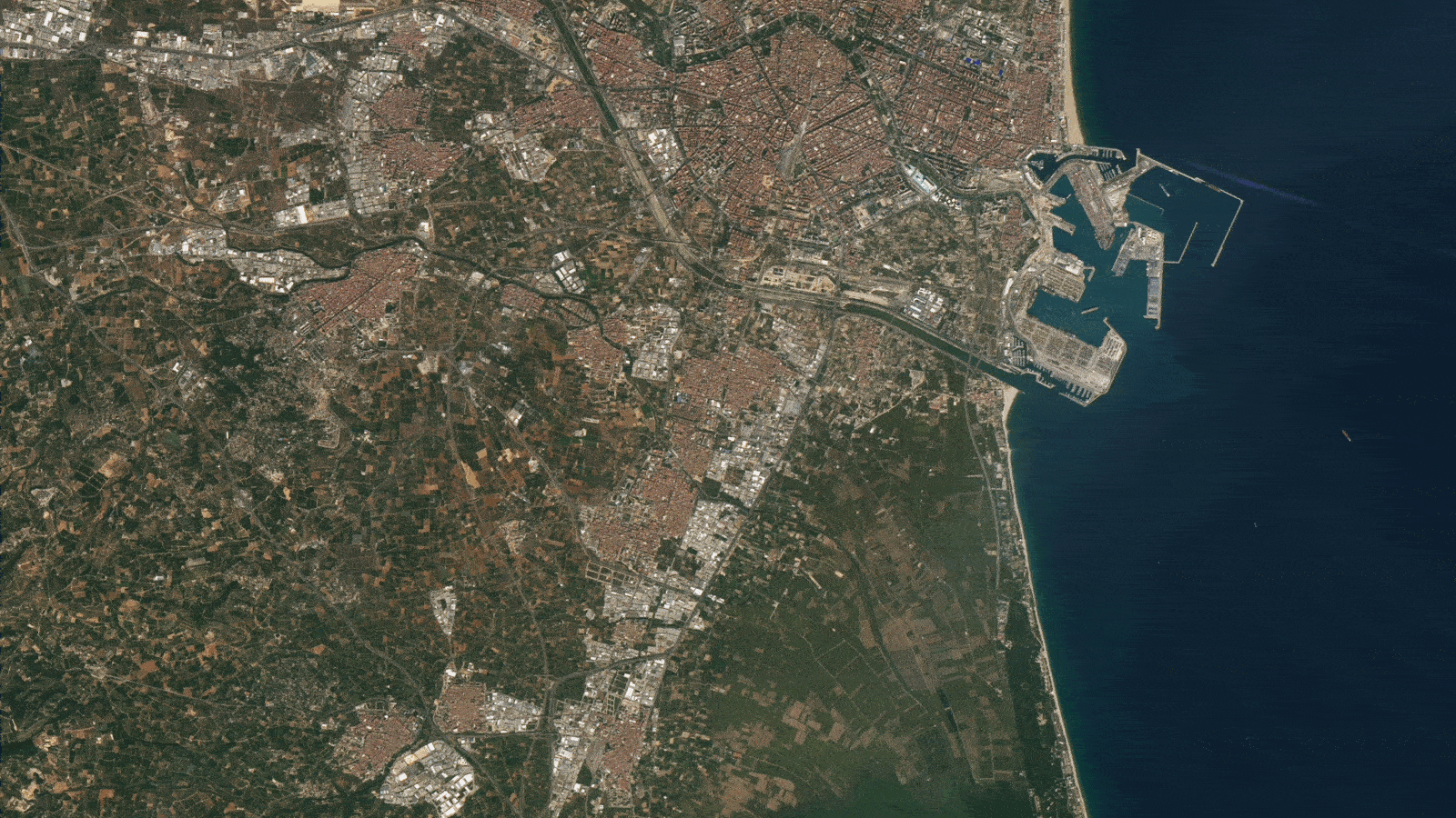
What's in the photo? Muddy flood water covering large parts of the city
Which satellite took the photo? Landsat 8
When was it taken? Oct. 30, 2024
Sobering satellite photos show the true extent of the unprecedented volume of muddy water that swept through the Spanish city of Valencia after an unexpected monsoon-like downpour triggered the country's worst floods in decades.
On Oct. 29, Spain was caught off guard when a surprise weather front suddenly unleashed torrential rains across large parts of the country, triggering widespread flash flooding. The extreme meteorological event has killed at least 214 people across the country, but the total number of casualties could still rise as emergency workers are still searching for missing people. This is the highest number of deaths for any flood in a single European country since 1967.
The worst affected area was the region surrounding Valencia, where more than a year's worth of rain fell in less than half a day. The heaviest rainfall was recorded in Chiva, where 20 inches (50 centimeters) of rain fell in 8 hours, according to Spain's meteorological agency. The deluge quickly caused overflows of nearby rivers, including the Turia, which flows through Valencia's greater metropolitan area as it drains into the Mediterranean Sea.
The streets of Valencia's suburbs were bombarded by surging waves of brown water, thick with sediment that was dredged up from the riverbed. The muddy mix flooded buildings, caused significant structural damage and swept away everything in its path including cars and even a semi-trailer truck. The aerial photos above show exactly how much sediment was unleashed upon the city and into the sea.
Spain has deployed at least 7,500 troops to Valencia to help with the clean-up operation, making this the largest peacetime military operation in the country's history, according to Reuters.
Cars and other debris were swept away by the surging flood water and have been left scattered across Valencia's streets caked in mud.
(Image credit: David Ramos/Getty Images)
The extreme rainfall is the result of a phenomenon known as Depresión Aislada en Niveles Altos (DANA) — a Spanish phrase that translates to isolated depression at high levels. A DANA is what meteorologists often refer to as a "cold drop," in which a mass of warm air collides with a stagnant mass of cold air in the upper atmosphere. This allows the cold patch to stay in one place for an extended period and can trigger high winds and heavy precipitation.
Sign up for the Live Science daily newsletter now
Get the world’s most fascinating discoveries delivered straight to your inbox.
"The winds may not be as violent as those of a hurricane, but in terms of rainfall and intensity, they can even surpass them," Jorge Olcina, director of the Climatology Laboratory at the University of Alicante, previously told Live Science. "These events can cause material damage and loss of life as significant as those of an average hurricane."
Experts told Live Science that DANAs are becoming increasingly common and are possible for more of the year thanks to human-caused climate change. For example, the recent downpour is believed to be tied to record-breaking sea surface temperatures this year.
Harry is a U.K.-based senior staff writer at Live Science. He studied marine biology at the University of Exeter before training to become a journalist. He covers a wide range of topics including space exploration, planetary science, space weather, climate change, animal behavior and paleontology. His recent work on the solar maximum won "best space submission" at the 2024 Aerospace Media Awards and was shortlisted in the "top scoop" category at the NCTJ Awards for Excellence in 2023. He also writes Live Science's weekly Earth from space series.

 Live Science Plus