Earth from space: Near-lifeless 'Land of Terror' looks like an alien landscape in the Sahara
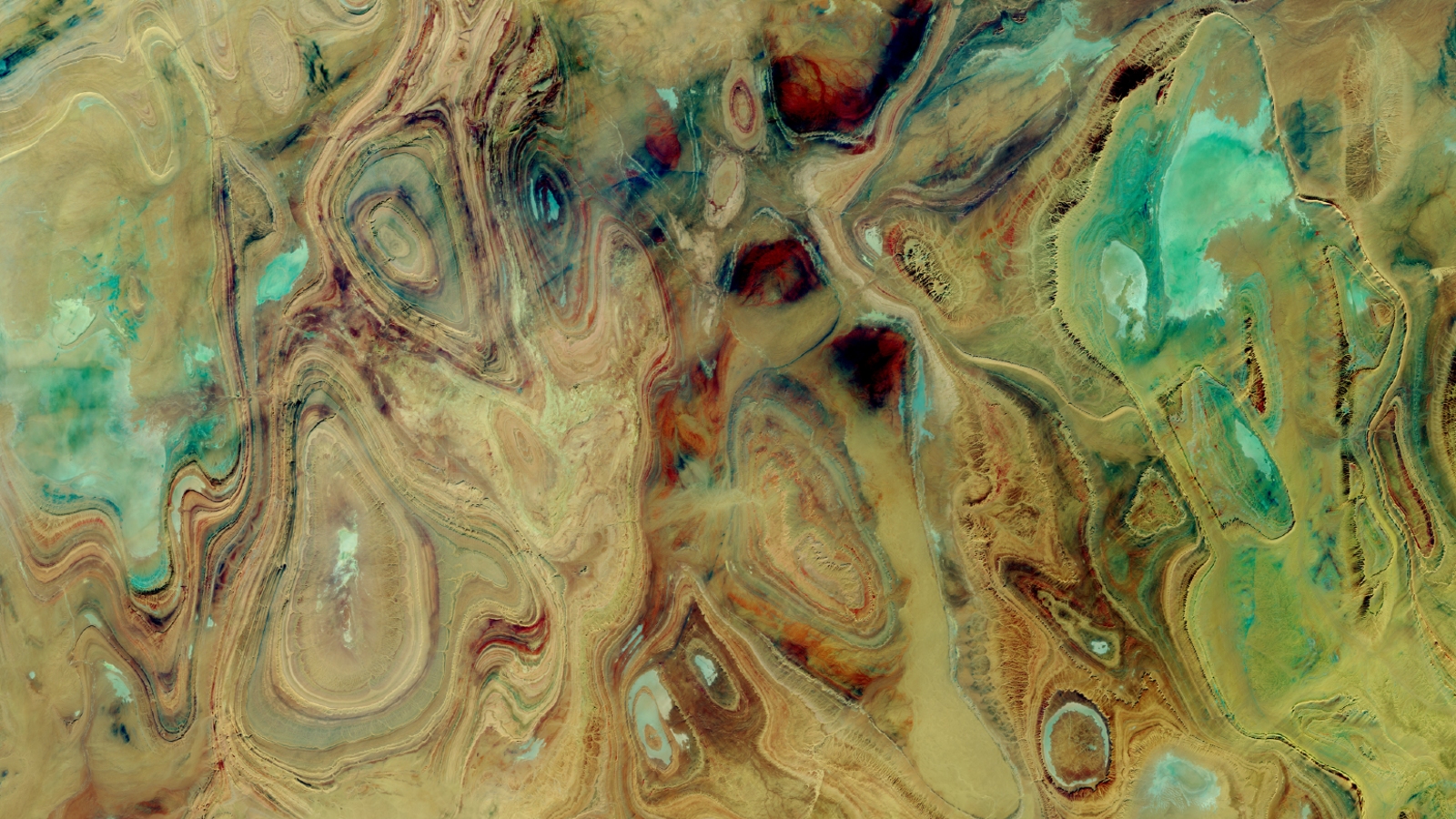
A 2017 satellite image of the Sahara's Tanezrouft Basin shows the abstract beauty in ancient rock folds and colorful salt flats that have been sculpted in this terrifying region over millions of years.

Get the world’s most fascinating discoveries delivered straight to your inbox.
You are now subscribed
Your newsletter sign-up was successful
Want to add more newsletters?

Delivered Daily
Daily Newsletter
Sign up for the latest discoveries, groundbreaking research and fascinating breakthroughs that impact you and the wider world direct to your inbox.

Once a week
Life's Little Mysteries
Feed your curiosity with an exclusive mystery every week, solved with science and delivered direct to your inbox before it's seen anywhere else.

Once a week
How It Works
Sign up to our free science & technology newsletter for your weekly fix of fascinating articles, quick quizzes, amazing images, and more

Delivered daily
Space.com Newsletter
Breaking space news, the latest updates on rocket launches, skywatching events and more!

Once a month
Watch This Space
Sign up to our monthly entertainment newsletter to keep up with all our coverage of the latest sci-fi and space movies, tv shows, games and books.

Once a week
Night Sky This Week
Discover this week's must-see night sky events, moon phases, and stunning astrophotos. Sign up for our skywatching newsletter and explore the universe with us!
Join the club
Get full access to premium articles, exclusive features and a growing list of member rewards.
Where is it? Tanezrouft Basin, the Sahara . [26.2089113, 2.27090884].
What's in the photo? Exposed paleozoic rock folds and colorful salt pans.
Which satellite took the photo? Landsat 8.
When was it taken? Oct. 22, 2017.
This 2017 satellite photo shows the abstract beauty of one of the world's most terrifyingly hostile environments.
The Tanezrouft Basin is a large region of the Sahara mainly located in southern Algeria and northern Mali. The area receives less than 0.2 inches (5 millimeters) of rain a year on average, making it "hyperarid." Temperatures can reach over 122 degrees Fahrenheit (50 degrees Celsius) during summer, according to NASA's Earth Observatory.
The basin is almost completely devoid of life apart from some Tuareg nomads who occasionally make the treacherous journey through the region on a caravan route that dates back more than 1,500 years. But this can be a deadly trip due to the region's lack of visible landmarks, which can cause even the most experienced travelers to get lost. As a result, the basin is colloquially known as the "Land of Terror."
Thousands of years of sandstorms have eroded sediment and sand from parts of the basin, which has revealed ancient concentric folds in the region's undulating sandstone bedrock that date to the Paleozoic era (541 million to 252 million years ago). Flashes of green are pitted around these folded rocks, which are salt flats often located in steep canyons.
When viewed from space, "the exposed geologic features create an arresting work of abstract art," NASA representatives wrote.
Related: 12 amazing images of Earth from space

The dramatic landscape also reveals that Tanezrouft Basin hasn't always been so hostile to life.
Get the world’s most fascinating discoveries delivered straight to your inbox.
Some of the salt flats in this real-color image lay in canyons up to 1,600 feet (490 meters) deep. The scale of these steep gullies and the shape of their smoothed sides are signs that they were carved out by flowing water, potentially from intermittent flooding over millions of years, P. Kyle House, a researcher with the U.S. Geological Survey, told NASA's Earth Observatory.
This suggests the region could have once been a more luscious environment potentially capable of supporting a diverse ecosystem.
Today, the salt flats and their canyons either lie within or intersect with the exposed sandstone folds, creating the shapes seen in this image. "These patterns are striking and reminiscent of landscapes formed on folded strata in, for example, the Red Desert of southern Wyoming and even parts of the heavily forested Appalachian Mountains of the Eastern United States," House said.

Harry is a U.K.-based senior staff writer at Live Science. He studied marine biology at the University of Exeter before training to become a journalist. He covers a wide range of topics including space exploration, planetary science, space weather, climate change, animal behavior and paleontology. His recent work on the solar maximum won "best space submission" at the 2024 Aerospace Media Awards and was shortlisted in the "top scoop" category at the NCTJ Awards for Excellence in 2023. He also writes Live Science's weekly Earth from space series.
 Live Science Plus


